T
Seller's Agent in 2026
The Allain Group
Compass
(781) 365-9954
161 in this area
265 Total Sales

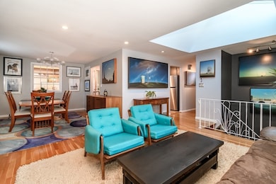


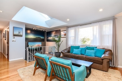
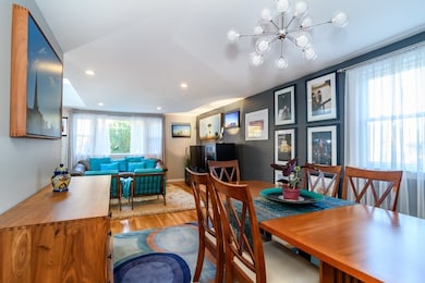
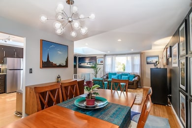
Looking for a turn key home mere minutes from both Natick & Wellesley Centers at an unbeatable price? Look no further than 191 East Central Street! This beautiful, modern 3 bed/2 bath raised ranch home has been fully updated & meticulously maintained so its new owners can move right in! Enter through a spacious foyer into the remodeled first level w/family room w/wood-burning fireplace, built-ins & large picture window, the perfect cozy retreat. There is also an office, full bath, laundry/exercise room & storage area. Make your way up the turned staircase w/sun shining through the multiple skylights to a living room, dining room & modern, updated kitchen w/bamboo flooring. Three bedrooms & 2nd full bath complete this main level, along with a 4-season room off of the kitchen, perfect as a studio space, playroom etc. Step outside to a hidden gem of a backyard complete with a large stone patio and mature trees. Central air, 1-car garage, newer systems & just 1 mile to Wellesley College!
| Date | Type | Sale Price | Title Company |
|---|---|---|---|
| Quit Claim Deed | $860,000 | -- | |
| Deed | $150,000 | -- | |
| Deed | $150,000 | -- |
| Date | Status | Loan Amount | Loan Type |
|---|---|---|---|
| Open | $688,000 | New Conventional | |
| Previous Owner | $148,000 | No Value Available | |
| Previous Owner | $149,169 | No Value Available | |
| Previous Owner | $146,347 | Purchase Money Mortgage |
| Date | Event | Price | List to Sale | Price per Sq Ft |
|---|---|---|---|---|
| 01/08/2026 01/08/26 | Sold | $860,000 | +1.3% | $453 / Sq Ft |
| 11/16/2025 11/16/25 | Pending | -- | -- | -- |
| 11/14/2025 11/14/25 | Price Changed | $849,000 | -1.2% | $448 / Sq Ft |
| 10/23/2025 10/23/25 | For Sale | $859,000 | -- | $453 / Sq Ft |
| Year | Tax Paid | Tax Assessment Tax Assessment Total Assessment is a certain percentage of the fair market value that is determined by local assessors to be the total taxable value of land and additions on the property. | Land | Improvement |
|---|---|---|---|---|
| 2025 | $7,508 | $627,800 | $383,900 | $243,900 |
| 2024 | $7,274 | $593,300 | $361,400 | $231,900 |
| 2023 | $7,134 | $564,400 | $347,700 | $216,700 |
| 2022 | $6,919 | $518,700 | $316,000 | $202,700 |
| 2021 | $6,640 | $487,900 | $297,900 | $190,000 |
| 2020 | $6,457 | $474,400 | $284,400 | $190,000 |
| 2019 | $6,030 | $474,400 | $284,400 | $190,000 |
| 2018 | $5,600 | $429,100 | $270,800 | $158,300 |
| 2017 | $5,200 | $385,500 | $239,500 | $146,000 |
| 2016 | $5,030 | $370,700 | $226,000 | $144,700 |
| 2015 | $4,961 | $359,000 | $226,000 | $133,000 |
T
Seller's Agent in 2026
The Allain Group
Compass
(781) 365-9954
161 in this area
265 Total Sales

Seller Co-Listing Agent in 2026
Jessica Allain
Compass
(617) 820-8114
85 in this area
110 Total Sales
K
Seller Co-Listing Agent in 2026
Kristen Scannell
Compass
16 in this area
18 Total Sales
Buyer's Agent in 2026
Shirley Chatelain
Coldwell Banker Realty - Newton
(617) 331-9141
2 in this area
38 Total Sales
Source: MLS Property Information Network (MLS PIN)
MLS Number: 73447275
APN: NATI-000037-000000-000008F
Disclaimer: Certain information contained herein is derived from information provided by parties other than Homes.com. All information provided is deemed reliable, but is not guaranteed to be accurate and should be independently verified.
![]() The property listing data and information, or the Images, set forth herein were provided to MLS Property Information Network, Inc. from third party sources, including sellers, lessors and public records, and were compiled by MLS Property Information Network, Inc. The property listing data and information, and the Images, are for the personal, non-commercial use of consumers having a good faith interest in purchasing or leasing listed properties of the type displayed to them and may not be used for any purpose other than to identify prospective properties which such consumers may have a good faith interest in purchasing or leasing. MLS Property Information Network, Inc. and its subscribers disclaim any and all representations and warranties as to the accuracy of the property listing data and information, or as to the accuracy of any of the Images, set forth herein.
The property listing data and information, or the Images, set forth herein were provided to MLS Property Information Network, Inc. from third party sources, including sellers, lessors and public records, and were compiled by MLS Property Information Network, Inc. The property listing data and information, and the Images, are for the personal, non-commercial use of consumers having a good faith interest in purchasing or leasing listed properties of the type displayed to them and may not be used for any purpose other than to identify prospective properties which such consumers may have a good faith interest in purchasing or leasing. MLS Property Information Network, Inc. and its subscribers disclaim any and all representations and warranties as to the accuracy of the property listing data and information, or as to the accuracy of any of the Images, set forth herein.
Ask me questions while you tour the home.