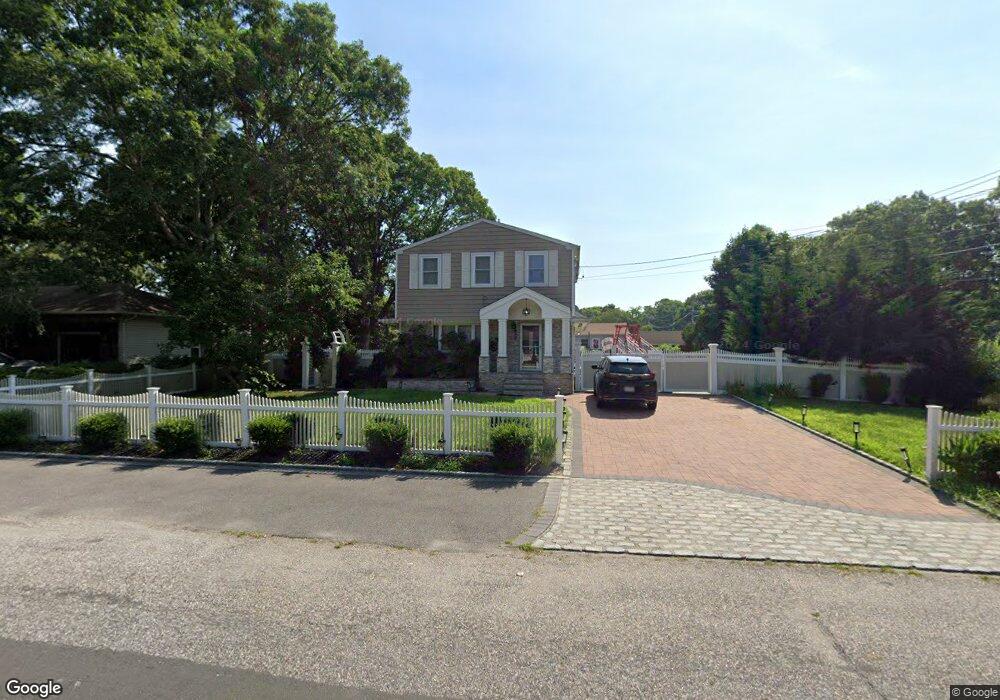
191 Hounslow Rd Shirley, NY 11967
Estimated Value: $417,000 - $610,000
5
Beds
2
Baths
1,800
Sq Ft
$297/Sq Ft
Est. Value
About This Home
This home is located at 191 Hounslow Rd, Shirley, NY 11967 and is currently estimated at $534,355, approximately $296 per square foot. 191 Hounslow Rd is a home located in Suffolk County with nearby schools including Nathaniel Woodhull Elementary School, William Paca Middle School, and William Floyd High School.
Ownership History
Date
Name
Owned For
Owner Type
Purchase Details
Closed on
Mar 31, 2010
Sold by
Wieboldt Erik
Bought by
Zoraida Properties Llc
Current Estimated Value
Purchase Details
Closed on
Mar 18, 2009
Sold by
Peridot Investment Inc
Bought by
Wieboldt Erik
Purchase Details
Closed on
May 31, 2001
Sold by
Sanzano Madeline Stewart
Bought by
Thame Blossom M
Home Financials for this Owner
Home Financials are based on the most recent Mortgage that was taken out on this home.
Original Mortgage
$159,497
Interest Rate
7.08%
Mortgage Type
FHA
Create a Home Valuation Report for This Property
The Home Valuation Report is an in-depth analysis detailing your home's value as well as a comparison with similar homes in the area
Home Values in the Area
Average Home Value in this Area
Purchase History
| Date | Buyer | Sale Price | Title Company |
|---|---|---|---|
| Zoraida Properties Llc | -- | -- | |
| Wieboldt Erik | $180,000 | Michael Cassidy | |
| Thame Blossom M | $149,990 | Fidelity National Title Ins |
Source: Public Records
Mortgage History
| Date | Status | Borrower | Loan Amount |
|---|---|---|---|
| Previous Owner | Thame Blossom M | $159,497 |
Source: Public Records
Tax History Compared to Growth
Tax History
| Year | Tax Paid | Tax Assessment Tax Assessment Total Assessment is a certain percentage of the fair market value that is determined by local assessors to be the total taxable value of land and additions on the property. | Land | Improvement |
|---|---|---|---|---|
| 2024 | $9,212 | $2,300 | $200 | $2,100 |
| 2023 | $9,212 | $2,300 | $200 | $2,100 |
| 2022 | $10,260 | $2,300 | $200 | $2,100 |
| 2021 | $10,260 | $2,300 | $200 | $2,100 |
| 2020 | $10,480 | $2,300 | $200 | $2,100 |
| 2019 | $10,480 | $0 | $0 | $0 |
| 2018 | $10,076 | $2,300 | $200 | $2,100 |
| 2017 | $10,076 | $2,300 | $200 | $2,100 |
| 2016 | $10,078 | $2,300 | $200 | $2,100 |
| 2015 | -- | $2,300 | $200 | $2,100 |
| 2014 | -- | $2,300 | $200 | $2,100 |
Source: Public Records
Map
Nearby Homes
- 11 The Green
- V LAND The Green
- VL - (Sec 937 Lot 14 The Green
- Vacant Lot The Green
- 137 Hounslow Rd
- 28 Beacon St
- 0 Amarr Dr Unit KEYL3493702
- 80 Breston Dr E
- 55 Lama Dr
- 8 Fleet Rd
- 64 Greentree Ct
- 43 Adobe Dr
- 62 Appel Dr E
- 42 Adobe Dr
- 36 Happy Acres Dr
- 36 Flintlock Dr
- 43 Ranch Dr
- 47 Musket Dr
- 17 Appel Dr E
- 72 Concord Rd