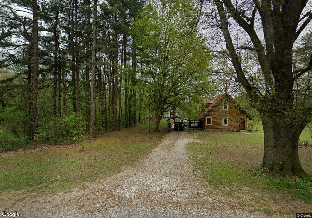
191 Pannell Dr Millington, TN 38053
Estimated Value: $277,759 - $339,000
--
Bed
2
Baths
2,006
Sq Ft
$157/Sq Ft
Est. Value
About This Home
This home is located at 191 Pannell Dr, Millington, TN 38053 and is currently estimated at $314,940, approximately $156 per square foot. 191 Pannell Dr is a home located in Tipton County with nearby schools including Drummonds Elementary School, Munford Middle School, and Munford High School.
Ownership History
Date
Name
Owned For
Owner Type
Purchase Details
Closed on
Mar 16, 1998
Sold by
Westmoreland Thomas O
Bought by
Westmoreland Lisa D
Current Estimated Value
Purchase Details
Closed on
Jul 11, 1994
Bought by
Westmoreland Thomas O
Purchase Details
Closed on
Jul 10, 1994
Purchase Details
Closed on
Mar 5, 1987
Purchase Details
Closed on
Jul 20, 1985
Bought by
Westmoreland Thomas O
Purchase Details
Closed on
Oct 2, 1973
Purchase Details
Closed on
Oct 1, 1973
Create a Home Valuation Report for This Property
The Home Valuation Report is an in-depth analysis detailing your home's value as well as a comparison with similar homes in the area
Home Values in the Area
Average Home Value in this Area
Purchase History
| Date | Buyer | Sale Price | Title Company |
|---|---|---|---|
| Westmoreland Lisa D | -- | -- | |
| Westmoreland Thomas O | $2,000 | -- | |
| -- | -- | -- | |
| -- | $6,000 | -- | |
| Westmoreland Thomas O | -- | -- | |
| -- | -- | -- | |
| -- | -- | -- |
Source: Public Records
Tax History Compared to Growth
Tax History
| Year | Tax Paid | Tax Assessment Tax Assessment Total Assessment is a certain percentage of the fair market value that is determined by local assessors to be the total taxable value of land and additions on the property. | Land | Improvement |
|---|---|---|---|---|
| 2024 | $1,176 | $77,300 | $7,025 | $70,275 |
| 2023 | $1,176 | $77,300 | $7,025 | $70,275 |
| 2022 | $1,111 | $54,450 | $5,175 | $49,275 |
| 2021 | $1,111 | $54,450 | $5,175 | $49,275 |
| 2020 | $1,110 | $54,450 | $5,175 | $49,275 |
| 2019 | $1,022 | $42,225 | $4,725 | $37,500 |
| 2018 | $1,022 | $42,225 | $4,725 | $37,500 |
| 2017 | $1,022 | $42,225 | $4,725 | $37,500 |
| 2016 | $1,022 | $42,225 | $4,725 | $37,500 |
| 2015 | $1,021 | $42,225 | $4,725 | $37,500 |
| 2014 | $1,020 | $42,221 | $0 | $0 |
Source: Public Records
Map
Nearby Homes
- 79 Marshall Cove
- 9640 New Bethel Rd
- 9590 Monasco Rd
- 9430 Monasco Rd
- 0 Herring Hill Rd
- 1476 Crigger Rd
- 979 Ray Bluff Rd
- 8925 Herring Hill Rd
- 0 Ray Bluff Rd
- 0 Dixon Rd
- 1932 Saint Paul Rd
- 0 St Paul Rd Unit 10199051
- 400 Whippoorwill Cir
- 3300 Cuba Millington Rd
- 8292 Rankin Branch Rd
- TRACT 9 Powder Plant Dr
- 0 Chambers Rd
- 138 Gayden Dr
- 8159 Epperson Mill Rd
- 2078 Russell Bond Rd
- 163 Pannell Dr
- 207 Pannell Dr
- 85 Pannell Dr
- 164 Pannell Dr
- 193 Pannell Dr
- 202 Pannell Dr
- 227 Pannell Dr
- 98 Pannell Dr
- 240 Pannell Dr
- 255 Pannell Dr
- 3409 Ray Bluff Rd
- 60 Pannell Dr
- 3379 Ray Bluff Rd
- 3321 Ray Bluff Rd
- 3535 Ray Bluff Rd
- 301 Pannell Dr
- 3281 Ray Bluff Rd
- 1432 Monasco Rd
- 3500 Ray Bluff Rd
- 298 Pannell Dr