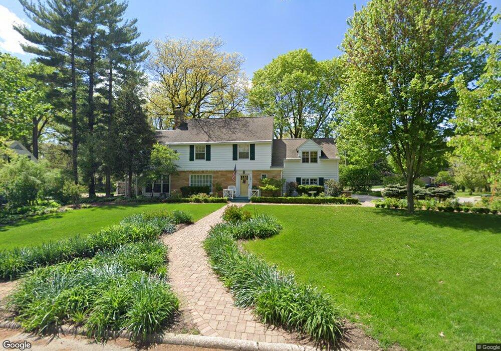
191 Pershing Rd Waterloo, IA 50701
Estimated Value: $342,147 - $389,000
3
Beds
4
Baths
2,559
Sq Ft
$142/Sq Ft
Est. Value
About This Home
This home is located at 191 Pershing Rd, Waterloo, IA 50701 and is currently estimated at $363,787, approximately $142 per square foot. 191 Pershing Rd is a home located in Black Hawk County with nearby schools including Kingsley Elementary School, Hoover Middle School, and West High School.
Ownership History
Date
Name
Owned For
Owner Type
Purchase Details
Closed on
Feb 11, 2009
Sold by
Weilein George L and Weilein Janice M
Bought by
Cass Harrison E and Cass Felicia A
Current Estimated Value
Create a Home Valuation Report for This Property
The Home Valuation Report is an in-depth analysis detailing your home's value as well as a comparison with similar homes in the area
Purchase History
| Date | Buyer | Sale Price | Title Company |
|---|---|---|---|
| Cass Harrison E | $260,000 | None Available |
Source: Public Records
Tax History
| Year | Tax Paid | Tax Assessment Tax Assessment Total Assessment is a certain percentage of the fair market value that is determined by local assessors to be the total taxable value of land and additions on the property. | Land | Improvement |
|---|---|---|---|---|
| 2025 | $6,494 | $343,000 | $46,240 | $296,760 |
| 2024 | $6,494 | $331,700 | $46,240 | $285,460 |
| 2023 | $5,766 | $322,850 | $46,240 | $276,610 |
| 2022 | $5,612 | $274,820 | $46,240 | $228,580 |
| 2021 | $5,760 | $274,820 | $46,240 | $228,580 |
| 2020 | $5,666 | $266,460 | $37,570 | $228,890 |
| 2019 | $5,666 | $266,460 | $37,570 | $228,890 |
| 2018 | $5,672 | $266,460 | $37,570 | $228,890 |
| 2017 | $5,848 | $266,460 | $37,570 | $228,890 |
| 2016 | $5,772 | $266,460 | $37,570 | $228,890 |
| 2015 | $5,772 | $266,460 | $37,570 | $228,890 |
| 2014 | $5,604 | $254,420 | $37,570 | $216,850 |
Source: Public Records
Map
Nearby Homes
- 250 Sheridan Rd
- 3024 W 4th St
- 1132 W Ridgeway Ave
- 2310 Westview Ave
- 1022 Hilltop Rd
- 581 Sheridan Rd
- Lot 6 Fischer Dr
- Lot 10 Paradise Estates First Addition
- Lot 44 Paradise Estates First Addition
- Lot 29 Paradise Estates First Addition
- Lot 1
- Lot 27 Paradise Estates First Addition
- Lot 54 Paradise Estates First Addition
- Lot 63 Paradise Estates First Addition
- Lot 39 Paradise Estates First Addition
- Lot 42 Paradise Estates First Addition
- Lot 13 Paradise Estates First Addition
- Lot 41 Paradise Estates First Addition
- Lot 14 Paradise Estates First Addition
- Lot 61 Paradise Estates First Addition
- 170 Berkshire Rd
- 181 Pershing Rd
- 171 Berkshire Rd
- 190 Pershing Rd
- 169 Berkshire Rd
- 180 Pershing Rd
- 160 Norfolk Rd
- 160 Berkshire Rd
- 146 Norfolk Rd
- 165 Berkshire Rd
- 212 Berkshire Rd
- 140 Norfolk Rd
- 165 Pershing Rd
- 166 Pershing Rd
- 224 Berkshire Rd
- 155 Berkshire Rd
- 130 Norfolk Rd
- 157 Pershing Rd
- 228 Berkshire Rd
- 125 Pauline Place