
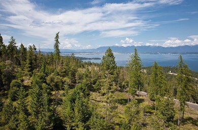
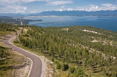


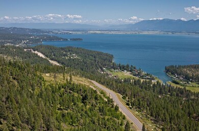

191 Ridge Line Dr Lakeside, MT 59922
Highlights
- Lake View
- Lakeside Elementary School Rated A-
- Park
About This Lot
As of December 2021Remarks: The level building site is accessed with ease and offers expansive Flathead Lake views. 4.11 acres with privacy in an exclusive aviation community close to Lakeside. Build the home of your dreams on this large parcel.
Last Agent to Sell the Property
Larry Phillips
Dean & Leininger, Inc License #RRE-BRO-LIC-99881
Property Details
Property Type
- Land
Est. Annual Taxes
- $1,078
Lot Details
- 4.11 Acre Lot
- Property fronts a private road
- Few Trees
- Zoning described as Lakeside Plan
HOA Fees
- $133 Monthly HOA Fees
Property Views
- Lake
- Trees
- Mountain
Utilities
- Well
- Septic Tank
- Phone Available
Listing and Financial Details
- Assessor Parcel Number 07370519201230000
Community Details
Recreation
- Park
Map
Home Values in the Area
Average Home Value in this Area
Property History
| Date | Event | Price | Change | Sq Ft Price |
|---|---|---|---|---|
| 12/08/2021 12/08/21 | Sold | -- | -- | -- |
| 10/21/2021 10/21/21 | Price Changed | $349,000 | -6.9% | -- |
| 09/17/2021 09/17/21 | Price Changed | $375,000 | -6.0% | -- |
| 08/24/2021 08/24/21 | For Sale | $399,000 | +50.6% | -- |
| 03/18/2021 03/18/21 | Sold | -- | -- | -- |
| 02/14/2021 02/14/21 | Pending | -- | -- | -- |
| 03/12/2019 03/12/19 | For Sale | $265,000 | -- | -- |
Tax History
| Year | Tax Paid | Tax Assessment Tax Assessment Total Assessment is a certain percentage of the fair market value that is determined by local assessors to be the total taxable value of land and additions on the property. | Land | Improvement |
|---|---|---|---|---|
| 2024 | $1,553 | $284,530 | $0 | $0 |
| 2023 | $2,040 | $284,530 | $0 | $0 |
| 2022 | $932 | $120,704 | $0 | $0 |
| 2021 | $906 | $120,704 | $0 | $0 |
| 2020 | $1,065 | $135,234 | $0 | $0 |
| 2019 | $1,050 | $135,234 | $0 | $0 |
| 2018 | $1,078 | $133,107 | $0 | $0 |
| 2017 | $996 | $133,107 | $0 | $0 |
| 2016 | $1,270 | $177,688 | $0 | $0 |
| 2015 | $1,318 | $177,688 | $0 | $0 |
| 2014 | $3,408 | $294,638 | $0 | $0 |
Mortgage History
| Date | Status | Loan Amount | Loan Type |
|---|---|---|---|
| Open | $541,000 | Construction | |
| Previous Owner | $183,200 | New Conventional |
Deed History
| Date | Type | Sale Price | Title Company |
|---|---|---|---|
| Grant Deed | -- | Fidelity National Title Compan | |
| Warranty Deed | -- | Fidelity National Title | |
| Warranty Deed | -- | Fidelity National Title | |
| Warranty Deed | -- | Insured Titles |
Source: Montana Regional MLS
MLS Number: 21902646
APN: 07-3705-19-2-01-23-0000
Disclaimer: Certain information contained herein is derived from information provided by parties other than Homes.com. All information provided is deemed reliable, but is not guaranteed to be accurate and should be independently verified.
![]() IDX information is provided exclusively for personal, non-commercial use, and may not be used for any purpose other than to identify prospective properties consumers may be interested in purchasing. Information is deemed reliable but not guaranteed.
IDX information is provided exclusively for personal, non-commercial use, and may not be used for any purpose other than to identify prospective properties consumers may be interested in purchasing. Information is deemed reliable but not guaranteed.
- 100 Tamarack Woods Dr
- 103 Tamarack Woods Dr
- 558 Bravehart Rd
- 100 Political Hill Rd
- 500 Blacktail Heights Rd
- 130 Redfield Ln
- 1555 Blacktail Rd
- 27 Bayview Dr
- 741 Lakeside Blvd
- 504 Ridge Line Dr
- 41 Bayview Dr
- 126 Crystal View Ct
- 108 Spoklie Dr
- 1065 Trappers Creeck Rd
- 162 Crystal View Ct
- 267 Adams St
- 150 Adams St Unit 5
- 150 Adams St Unit 4
- 316 Spurwing Loop
- 610 Grayling Rd