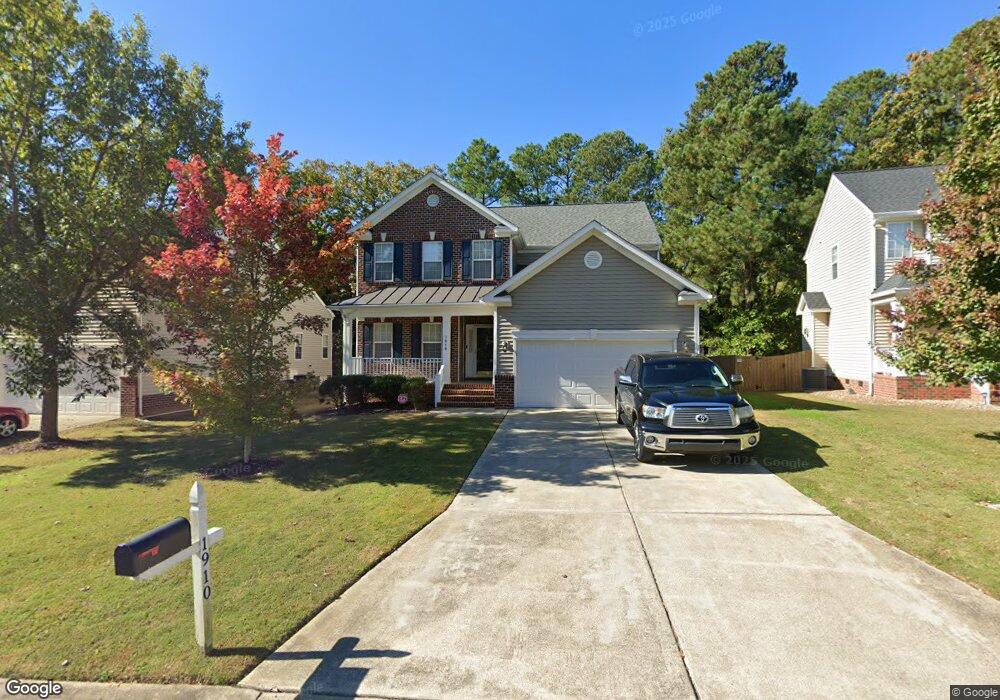
1910 Carnation Dr Durham, NC 27703
South Durham NeighborhoodEstimated Value: $461,000 - $522,000
4
Beds
3
Baths
2,546
Sq Ft
$193/Sq Ft
Est. Value
About This Home
This home is located at 1910 Carnation Dr, Durham, NC 27703 and is currently estimated at $491,613, approximately $193 per square foot. 1910 Carnation Dr is a home located in Durham County with nearby schools including Bethesda Elementary School, John W Neal Middle School, and Southern School of Energy & Sustainability.
Ownership History
Date
Name
Owned For
Owner Type
Purchase Details
Closed on
Jan 28, 2003
Sold by
Centex Homes
Bought by
Smith Morris Conrad
Current Estimated Value
Home Financials for this Owner
Home Financials are based on the most recent Mortgage that was taken out on this home.
Original Mortgage
$160,500
Outstanding Balance
$68,888
Interest Rate
5.98%
Estimated Equity
$422,725
Create a Home Valuation Report for This Property
The Home Valuation Report is an in-depth analysis detailing your home's value as well as a comparison with similar homes in the area
Home Values in the Area
Average Home Value in this Area
Purchase History
| Date | Buyer | Sale Price | Title Company |
|---|---|---|---|
| Smith Morris Conrad | $201,000 | -- |
Source: Public Records
Mortgage History
| Date | Status | Borrower | Loan Amount |
|---|---|---|---|
| Open | Smith Morris Conrad | $160,500 | |
| Closed | Smith Morris Conrad | $30,090 |
Source: Public Records
Tax History
| Year | Tax Paid | Tax Assessment Tax Assessment Total Assessment is a certain percentage of the fair market value that is determined by local assessors to be the total taxable value of land and additions on the property. | Land | Improvement |
|---|---|---|---|---|
| 2025 | $5,402 | $544,892 | $128,100 | $416,792 |
| 2024 | $3,996 | $286,444 | $54,900 | $231,544 |
| 2023 | $3,752 | $286,355 | $54,810 | $231,545 |
| 2022 | $3,588 | $280,367 | $54,810 | $225,557 |
| 2021 | $3,572 | $280,367 | $54,810 | $225,557 |
| 2020 | $3,487 | $280,367 | $54,810 | $225,557 |
| 2019 | $3,487 | $280,367 | $54,810 | $225,557 |
| 2018 | $3,545 | $261,321 | $42,630 | $218,691 |
| 2017 | $3,519 | $261,321 | $42,630 | $218,691 |
| 2016 | $3,400 | $261,321 | $42,630 | $218,691 |
| 2015 | $3,889 | $280,916 | $50,322 | $230,594 |
| 2014 | $3,889 | $280,916 | $50,322 | $230,594 |
Source: Public Records
Map
Nearby Homes
- 1713 Magnolia Oak Place
- 3309 Forest Grove Ct
- 1016 Hollis Cir
- 2701 Skybrook Ln
- 4514 Cottendale Dr
- 3503 Long Ridge Rd
- 1222 Flyfish Ave
- 2216 Jollay St
- 3712 Appling Way
- 111 Lang St
- 910 Wood Meadow Ln
- 913 Wood Chapel Ln
- 909 Wood Chapel Ln
- 5024 Dragonfly Dr
- 4613 Angier Ave
- 1018 Flyfish Ave
- 4512 Brimmer St
- 2709 Hamilton Green Dr
- 102 Kingsley Woods Dr
- 1200 Bluewater Way
- 1912 Carnation Dr
- 1908 Carnation Dr
- 1914 Carnation Dr
- 1906 Carnation Dr
- 1907 Carnation Dr
- 1916 Carnation Dr
- 2505 Bonnie Brae Rd
- 1909 Carnation Dr
- 2431 Bonnie Brae Rd
- 1905 Carnation Dr
- 1904 Carnation Dr
- 1911 Carnation Dr
- 1918 Carnation Dr
- 1903 Carnation Dr
- 4801 Mistletoe Ln
- 1 Mayflower Ct
- 13 Laurel Leaf Ct
- 2509 Bonnie Brae Rd
- 15 Laurel Leaf Ct
- 2002 Carnation Dr
Your Personal Tour Guide
Ask me questions while you tour the home.