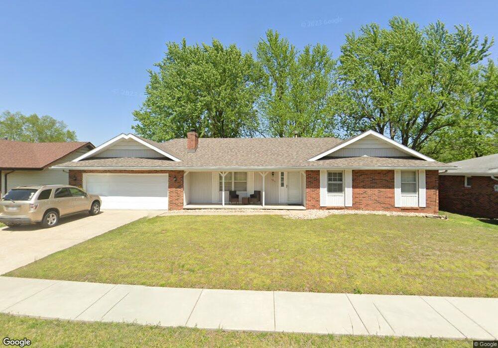
1911 E Wheatridge Dr Springfield, MO 65803
Estimated Value: $225,000 - $267,000
3
Beds
2
Baths
1,560
Sq Ft
$154/Sq Ft
Est. Value
About This Home
This home is located at 1911 E Wheatridge Dr, Springfield, MO 65803 and is currently estimated at $240,937, approximately $154 per square foot. 1911 E Wheatridge Dr is a home located in Greene County with nearby schools including Pleasant View K-8 School, Hillcrest High School, and Dayspring Christian School.
Ownership History
Date
Name
Owned For
Owner Type
Purchase Details
Closed on
May 13, 2013
Sold by
Stidham Bruce E
Bought by
Stidham Connie M
Current Estimated Value
Purchase Details
Closed on
Dec 18, 2012
Sold by
Stidham Bruce E
Bought by
Stidham Connie M and Stidham Bruce E
Purchase Details
Closed on
Dec 5, 2011
Sold by
Lykens Margaret and Lykens Larry W
Bought by
Stidham Bruce
Purchase Details
Closed on
Jul 29, 2008
Sold by
Eslick Callahan Dorothy and Callahan Robert
Bought by
Lykens Margaret and Lykens Larry W
Create a Home Valuation Report for This Property
The Home Valuation Report is an in-depth analysis detailing your home's value as well as a comparison with similar homes in the area
Purchase History
| Date | Buyer | Sale Price | Title Company |
|---|---|---|---|
| Stidham Connie M | -- | None Available | |
| Stidham Connie M | -- | None Available | |
| Stidham Bruce | -- | Choice Escrow & Land Title L | |
| Lykens Margaret | -- | None Available |
Source: Public Records
Tax History
| Year | Tax Paid | Tax Assessment Tax Assessment Total Assessment is a certain percentage of the fair market value that is determined by local assessors to be the total taxable value of land and additions on the property. | Land | Improvement |
|---|---|---|---|---|
| 2025 | $1,531 | $28,310 | $8,320 | $19,990 |
| 2024 | $1,381 | $23,860 | $4,180 | $19,680 |
| 2023 | $1,374 | $23,860 | $4,180 | $19,680 |
| 2022 | $1,273 | $21,660 | $4,180 | $17,480 |
| 2021 | $1,218 | $21,660 | $4,180 | $17,480 |
| 2020 | $1,174 | $19,820 | $4,180 | $15,640 |
| 2019 | $1,141 | $19,820 | $4,180 | $15,640 |
| 2018 | $946 | $16,360 | $3,230 | $13,130 |
| 2017 | $938 | $16,360 | $3,230 | $13,130 |
| 2016 | $936 | $16,360 | $3,230 | $13,130 |
| 2015 | $929 | $16,360 | $3,230 | $13,130 |
| 2014 | $928 | $16,360 | $3,230 | $13,130 |
Source: Public Records
Map
Nearby Homes
- 3839 N Stewart Ave
- 1923 E Valley Water Mill Rd
- 3975 N Stewart Ave
- 4260 N State Highway H
- 3424 N Darwin Ave
- 2393 E Valley Water Mill Rd
- 3753 N Pickwick Ave
- 3749 N Pickwick Ave
- 3983 N Courtney Cir
- 1349 E Stoneridge St
- 1270 E Ogorman Ct
- 4541b N Lanier Ln
- 4541 N Lanier Ln
- Tract C N Farm Road 173
- 3957 N Springlawn Ave
- 3969 N Springlawn Ave
- 1626 E Farm Road 92
- 1255 E Bonaire Dr
- 1414 E Smith St
- 1502 E McClernon St
- 1909 E Wheatridge Dr
- 1917 E Wheatridge Dr
- 1907 E Wheatridge Dr
- 1923 E Wheatridge Dr
- 1910 E Wheatridge Dr
- 1908 E Wheatridge Dr
- 1918 E Wheatridge Dr
- 1905 E Wheatridge Dr
- 1904 E Wheatridge Dr
- 1924 E Wheatridge Dr
- 1929 E Wheatridge Dr
- 1900 E Wheatridge Dr
- 1930 E Wheatridge Dr
- 1911 E Stoneridge Dr
- 1901 E Wheatridge Dr
- 1905 E Stoneridge Dr
- 1919 E Stoneridge Dr
- 1863 E Stoneridge Dr
- 1925 E Stoneridge Dr
- 1904 E Burntwood St
Your Personal Tour Guide
Ask me questions while you tour the home.