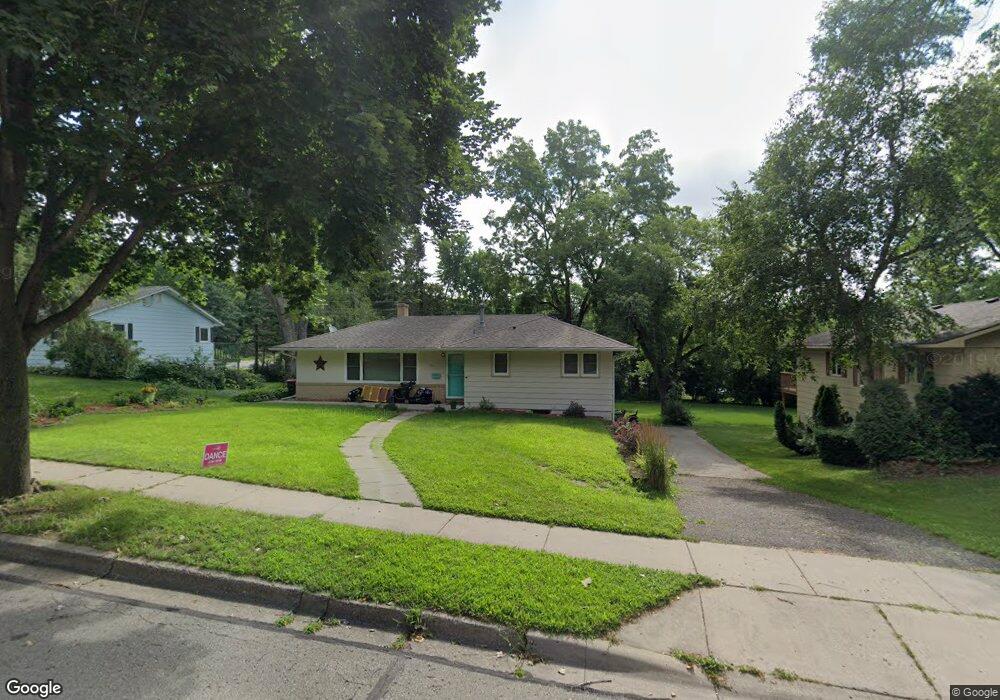
1911 Twin Bluff Rd Red Wing, MN 55066
Estimated Value: $262,221 - $302,000
3
Beds
2
Baths
1,124
Sq Ft
$252/Sq Ft
Est. Value
About This Home
This home is located at 1911 Twin Bluff Rd, Red Wing, MN 55066 and is currently estimated at $283,305, approximately $252 per square foot. 1911 Twin Bluff Rd is a home located in Goodhue County with nearby schools including Sunnyside Elementary School, Burnside Elementary School, and Twin Bluff Middle School.
Ownership History
Date
Name
Owned For
Owner Type
Purchase Details
Closed on
Oct 10, 2017
Sold by
Schmidt Sherry J
Bought by
Korsten Niles and Korsten Mary
Current Estimated Value
Purchase Details
Closed on
Jun 22, 2006
Sold by
Holst Morris F and Holst Leah M
Bought by
Schmidt Sherry J
Purchase Details
Closed on
Apr 12, 2001
Sold by
Rivers Patrick J and Rivers Erika R L
Bought by
Holst Morris F
Purchase Details
Closed on
Jul 24, 1998
Sold by
Wohler Lauretta L
Bought by
Rivers Patrick J and Patrick Erika R L
Create a Home Valuation Report for This Property
The Home Valuation Report is an in-depth analysis detailing your home's value as well as a comparison with similar homes in the area
Home Values in the Area
Average Home Value in this Area
Purchase History
| Date | Buyer | Sale Price | Title Company |
|---|---|---|---|
| Korsten Niles | $158,500 | Goodhue County Abstract | |
| Schmidt Sherry J | $149,000 | -- | |
| Holst Morris F | $107,000 | -- | |
| Rivers Patrick J | $76,000 | -- |
Source: Public Records
Tax History Compared to Growth
Tax History
| Year | Tax Paid | Tax Assessment Tax Assessment Total Assessment is a certain percentage of the fair market value that is determined by local assessors to be the total taxable value of land and additions on the property. | Land | Improvement |
|---|---|---|---|---|
| 2025 | $2,636 | $221,300 | $57,100 | $164,200 |
| 2024 | -- | $217,900 | $57,100 | $160,800 |
| 2023 | $2,476 | $206,100 | $57,100 | $149,000 |
| 2022 | $2,304 | $198,900 | $51,000 | $147,900 |
| 2021 | $2,156 | $172,500 | $51,000 | $121,500 |
| 2020 | $2,148 | $164,700 | $51,000 | $113,700 |
| 2019 | $2,120 | $154,800 | $51,000 | $103,800 |
| 2018 | $1,708 | $154,700 | $49,000 | $105,700 |
| 2017 | $1,676 | $137,800 | $49,000 | $88,800 |
| 2016 | $1,554 | $137,000 | $49,000 | $88,000 |
| 2015 | $1,476 | $133,900 | $49,000 | $84,900 |
| 2014 | -- | $127,800 | $49,000 | $78,800 |
Source: Public Records
Map
Nearby Homes
- 1927 Twin Bluff Rd
- 1846 Twin Bluff Rd
- 1825 Twin Bluff Rd
- 1838 Spruce Dr
- 1903 Lenore Ln
- 1606 Reichert Ave
- 1224 Tee Up Ln
- 1164 Hawthorn St
- 1632 Spruce Dr
- 769 Pioneer Rd
- 2345 S Oak Dr
- 732 Hi Park Ave
- 1822 Bohmbach Dr
- 672 Hi Park Ave
- 676 Hi Park Ave
- 642 Grace St
- 1028 Kingman Ave
- 611 Cherrywood Ct
- 1012 West Ave
- 1029 Putnam Ave
- 1903 Twin Bluff Rd
- 1919 Twin Bluff Rd
- 1914 Launa Ave
- 1922 Launa Ave
- 1041 Hallstrom Dr
- 1930 Launa Ave
- 1910 Twin Bluff Rd
- 1918 Twin Bluff Rd
- 1902 Twin Bluff Rd
- 1924 Twin Bluff Rd
- 1841 Twin Bluff Rd
- 1940 Launa Ave
- 1935 Twin Bluff Rd
- 1950 Launa Ave
- 1936 Twin Bluff Rd
- 1858 Spruce Dr
- 1833 Twin Bluff Rd
- 1919 Launa Ave
- 1958 Launa Ave
- 1945 Twin Bluff Rd