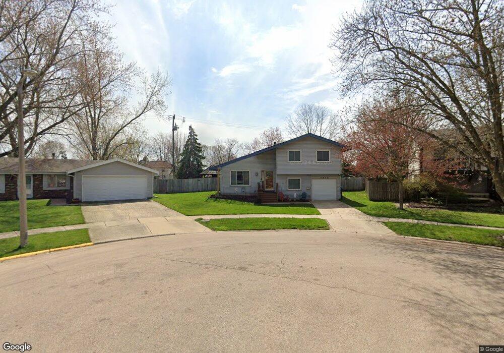
1912 Ash Ct Aurora, IL 60506
Edgelawn Randall NeighborhoodEstimated Value: $291,016 - $320,000
3
Beds
3
Baths
1,453
Sq Ft
$210/Sq Ft
Est. Value
About This Home
This home is located at 1912 Ash Ct, Aurora, IL 60506 and is currently estimated at $305,004, approximately $209 per square foot. 1912 Ash Ct is a home located in Kane County with nearby schools including Fearn Elementary School, Jewel Middle School, and West Aurora High School.
Ownership History
Date
Name
Owned For
Owner Type
Purchase Details
Closed on
Jan 7, 2002
Sold by
Harding Michael and Freed Tracey M
Bought by
Harding Michael and Harding Tracey M
Current Estimated Value
Home Financials for this Owner
Home Financials are based on the most recent Mortgage that was taken out on this home.
Original Mortgage
$22,900
Interest Rate
6.87%
Mortgage Type
Stand Alone Second
Purchase Details
Closed on
Jul 22, 1998
Sold by
Benson Gregory L and Benson Tammy Ladonna
Bought by
Harding Michael T and Freed Tracey M
Home Financials for this Owner
Home Financials are based on the most recent Mortgage that was taken out on this home.
Original Mortgage
$114,000
Outstanding Balance
$21,508
Interest Rate
7.03%
Estimated Equity
$283,496
Create a Home Valuation Report for This Property
The Home Valuation Report is an in-depth analysis detailing your home's value as well as a comparison with similar homes in the area
Home Values in the Area
Average Home Value in this Area
Purchase History
| Date | Buyer | Sale Price | Title Company |
|---|---|---|---|
| Harding Michael | -- | Chicago Title Insurance Co | |
| Harding Michael T | $120,000 | First American Title Ins Co |
Source: Public Records
Mortgage History
| Date | Status | Borrower | Loan Amount |
|---|---|---|---|
| Closed | Harding Michael | $22,900 | |
| Open | Harding Michael T | $114,000 |
Source: Public Records
Tax History
| Year | Tax Paid | Tax Assessment Tax Assessment Total Assessment is a certain percentage of the fair market value that is determined by local assessors to be the total taxable value of land and additions on the property. | Land | Improvement |
|---|---|---|---|---|
| 2024 | $6,181 | $78,062 | $12,573 | $65,489 |
| 2023 | $5,974 | $69,748 | $11,234 | $58,514 |
| 2022 | $5,633 | $63,639 | $10,250 | $53,389 |
| 2021 | $5,413 | $59,249 | $9,543 | $49,706 |
| 2020 | $5,873 | $62,735 | $8,864 | $53,871 |
| 2019 | $5,684 | $58,126 | $8,213 | $49,913 |
| 2018 | $5,385 | $53,940 | $7,597 | $46,343 |
| 2017 | $4,927 | $47,875 | $8,858 | $39,017 |
| 2016 | $4,551 | $42,839 | $7,593 | $35,246 |
| 2015 | -- | $38,371 | $6,529 | $31,842 |
| 2014 | -- | $36,536 | $6,279 | $30,257 |
| 2013 | -- | $37,082 | $6,190 | $30,892 |
Source: Public Records
Map
Nearby Homes
- 991 Sapphire Ln
- 959 Sapphire Ln
- 975 Sapphire Ln
- 963 Sapphire Ln
- 987 Sapphire Ln
- 983 Sapphire Ln
- 980 Sapphire Ln
- 968 Sapphire Ln
- 960 Sapphire Ln
- 972 Sapphire Ln
- 988 Sapphire Ln
- 976 Sapphire Ln
- 984 Sapphire Ln
- 1930 Sapphire Ln
- 1475 Elder Dr
- 1847 Brighton Cir
- 1071 Almond Dr
- 1815 Brighton Cir
- 833 N Randall Rd Unit C4
- 1421 Heather Dr
- 1914 Ash Ct
- 1910 Ash Ct
- 1922 Ashwood Ln
- 1916 Ash Ct
- 1911 Ash Ct
- 1926 Ashwood Ln
- 1871 Sapphire Ln
- 1881 Sapphire Ln
- 1913 Ash Ct
- 1886 Ashwood Ln
- 1891 Sapphire Ln
- 1915 Ash Ct
- 1930 Ashwood Ln
- 1882 Ashwood Ln
- 1901 Sapphire Ln
- 1861 Sapphire Ln
- 1923 Ashwood Ln
- 1919 Ashwood Ln
- 1903 Ashwood Ln
- 1934 Ashwood Ln
Your Personal Tour Guide
Ask me questions while you tour the home.