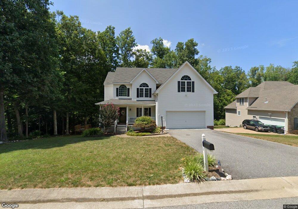
1912 Bantry Dr Midlothian, VA 23114
Estimated Value: $490,490 - $540,000
4
Beds
3
Baths
2,272
Sq Ft
$224/Sq Ft
Est. Value
About This Home
This home is located at 1912 Bantry Dr, Midlothian, VA 23114 and is currently estimated at $508,373, approximately $223 per square foot. 1912 Bantry Dr is a home located in Chesterfield County with nearby schools including W W Gordon Elementary School, Midlothian Middle School, and Monacan High School.
Ownership History
Date
Name
Owned For
Owner Type
Purchase Details
Closed on
Apr 8, 2008
Sold by
Dusing Timothy M
Bought by
Clark Christopher H
Current Estimated Value
Purchase Details
Closed on
Jun 9, 2006
Sold by
Capitol Builders
Bought by
Dusing Tim
Home Financials for this Owner
Home Financials are based on the most recent Mortgage that was taken out on this home.
Original Mortgage
$257,526
Interest Rate
6.62%
Mortgage Type
New Conventional
Create a Home Valuation Report for This Property
The Home Valuation Report is an in-depth analysis detailing your home's value as well as a comparison with similar homes in the area
Home Values in the Area
Average Home Value in this Area
Purchase History
| Date | Buyer | Sale Price | Title Company |
|---|---|---|---|
| Clark Christopher H | $317,500 | -- | |
| Dusing Tim | $316,755 | -- |
Source: Public Records
Mortgage History
| Date | Status | Borrower | Loan Amount |
|---|---|---|---|
| Previous Owner | Dusing Tim | $257,526 |
Source: Public Records
Tax History
| Year | Tax Paid | Tax Assessment Tax Assessment Total Assessment is a certain percentage of the fair market value that is determined by local assessors to be the total taxable value of land and additions on the property. | Land | Improvement |
|---|---|---|---|---|
| 2025 | $3,913 | $436,800 | $64,900 | $371,900 |
| 2024 | $3,913 | $406,900 | $60,400 | $346,500 |
| 2023 | $3,539 | $388,900 | $58,600 | $330,300 |
| 2022 | $3,252 | $353,500 | $55,900 | $297,600 |
| 2021 | $2,994 | $312,500 | $54,100 | $258,400 |
| 2020 | $2,957 | $311,300 | $54,100 | $257,200 |
| 2019 | $2,843 | $299,300 | $54,100 | $245,200 |
| 2018 | $2,754 | $289,900 | $54,000 | $235,900 |
| 2017 | $2,587 | $269,500 | $54,000 | $215,500 |
| 2016 | $2,532 | $263,700 | $54,000 | $209,700 |
| 2015 | $2,411 | $251,100 | $54,000 | $197,100 |
| 2014 | $2,400 | $250,000 | $54,000 | $196,000 |
Source: Public Records
Map
Nearby Homes
- 1625 Upperbury Dr
- 11625 Explorer Dr
- 11806 Winbury Ct
- 11400 Crawford Wood Terrace
- 1520 Exbury Dr
- 11906 Lockett Ridge Place
- 11724 Duxbury Ct
- 11211 Pennway Dr
- 11401 Mansfield Crossing Ln
- 2912 Chislet Dr
- 11301 Mansfield Crossing Ct
- 2613 McManaway Dr
- 2730 McManaway Dr
- 2019 Condrey Ridge Dr
- 11101 Pennway Dr
- 12536 St Thomas Ct
- 11918 Gordon School Rd
- 3130 Tadley Dr
- 803 Mountain Laurel Ct
- 12503 Needle Rush Way
- 1906 Bantry Dr
- 1901 Bantry Dr
- 1900 Bantry Dr
- 1891 Bantry Dr
- 1737 Westbury Ridge Dr
- 1925 Bantry Dr
- 1730 Westbury Ridge Dr
- 1885 Bantry Dr
- 1600 Bantry Loop
- 1931 Bantry Dr
- 1613 Bantry Loop
- 1724 Westbury Ridge Dr
- 1731 Westbury Ridge Dr
- 1879 Bantry Dr
- 1878 Bantry Dr
- 11713 Westbury Bluff Dr
- 1718 Westbury Ridge Dr
- 1936 Bantry Dr
- 1725 Westbury Ridge Dr
- 11700 Westbury Bluff Dr
Your Personal Tour Guide
Ask me questions while you tour the home.