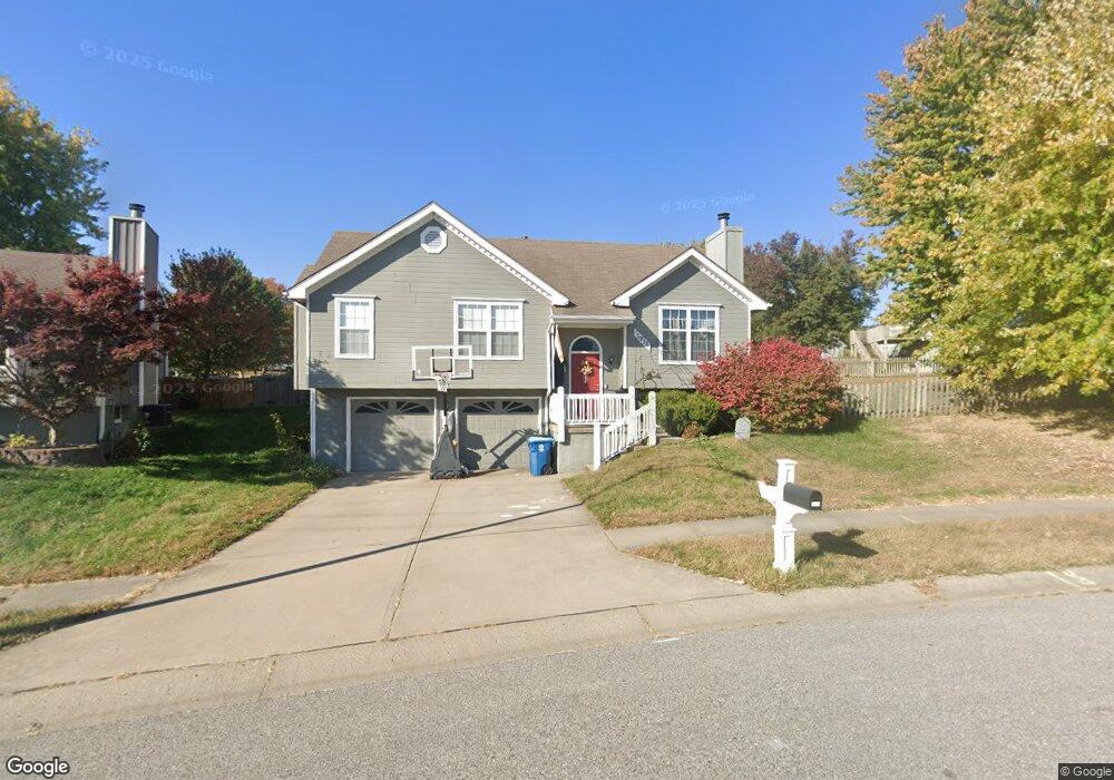
1912 Pheasant Ln Liberty, MO 64068
Estimated Value: $297,000 - $335,000
3
Beds
3
Baths
1,134
Sq Ft
$272/Sq Ft
Est. Value
About This Home
This home is located at 1912 Pheasant Ln, Liberty, MO 64068 and is currently estimated at $308,555, approximately $272 per square foot. 1912 Pheasant Ln is a home located in Clay County with nearby schools including Lillian Schumacher Elementary School, Liberty Middle School, and Liberty High School.
Ownership History
Date
Name
Owned For
Owner Type
Purchase Details
Closed on
Nov 21, 2012
Sold by
Bridges Justin K and Bridges Melissa J
Bought by
Bridges Justin K and Bridges Melissa J
Current Estimated Value
Purchase Details
Closed on
Nov 10, 2008
Sold by
Krausse Chad A and Krausse Holly
Bought by
Hamm Melissa J
Home Financials for this Owner
Home Financials are based on the most recent Mortgage that was taken out on this home.
Original Mortgage
$115,200
Outstanding Balance
$74,675
Interest Rate
6.08%
Mortgage Type
Purchase Money Mortgage
Estimated Equity
$233,880
Create a Home Valuation Report for This Property
The Home Valuation Report is an in-depth analysis detailing your home's value as well as a comparison with similar homes in the area
Purchase History
| Date | Buyer | Sale Price | Title Company |
|---|---|---|---|
| Bridges Justin K | -- | None Available | |
| Hamm Melissa J | -- | United Title Company Inc |
Source: Public Records
Mortgage History
| Date | Status | Borrower | Loan Amount |
|---|---|---|---|
| Open | Hamm Melissa J | $115,200 |
Source: Public Records
Tax History
| Year | Tax Paid | Tax Assessment Tax Assessment Total Assessment is a certain percentage of the fair market value that is determined by local assessors to be the total taxable value of land and additions on the property. | Land | Improvement |
|---|---|---|---|---|
| 2025 | $2,622 | $39,160 | -- | -- |
| 2024 | $2,622 | $34,090 | -- | -- |
| 2023 | $2,666 | $34,090 | $0 | $0 |
| 2022 | $2,393 | $30,210 | $0 | $0 |
| 2021 | $2,374 | $30,210 | $6,650 | $23,560 |
| 2020 | $2,155 | $25,750 | $0 | $0 |
| 2019 | $2,155 | $25,750 | $0 | $0 |
| 2018 | $2,019 | $23,690 | $0 | $0 |
| 2017 | $2,000 | $23,690 | $3,990 | $19,700 |
| 2016 | $2,000 | $23,690 | $3,990 | $19,700 |
| 2015 | $2,001 | $23,690 | $3,990 | $19,700 |
| 2014 | $1,937 | $22,760 | $3,990 | $18,770 |
Source: Public Records
Map
Nearby Homes
- 939 Goldfinch Ln
- 1877 Chickadee Dr
- 1836 Chickadee Dr
- 2218 Liberty Landing Rd
- 1628 Magnolia Ave
- 2600 Magnolia Ave
- 345 Cates Ct
- 1200 Silverleaf Ct
- 1059 Fir Ln
- 1172 White Oak Ln
- 1022 Jasmine Dr
- 1026 Jasmine Dr
- 1015 Poplar Ln
- 1007 Poplar Ln
- 1027 Fir Ln
- 653 Butternut Ct
- 1020 Poplar Ln
- 988 Poplar Ln
- 1015 Fir Ln
- 904 Paw Ln
- 1916 Pheasant Ln
- 1225 Pheasant Ct
- 1221 Pheasant Ct
- 1920 Pheasant Ln
- 1212 Quail Ridge Dr
- 1909 Pheasant Ln
- 1913 Pheasant Ln
- 1924 Pheasant Ln
- 1229 Pheasant Ct
- 1217 Quail Ridge Dr
- 1208 Quail Ridge Dr
- 1220 Pheasant Ct
- 1224 Pheasant Ct
- 1917 Pheasant Ln
- 1901 Claywoods Pkwy
- 1925 Pheasant Ln
- 1213 Quail Ridge Dr
- 1925 Claywoods Pkwy
- 1921 Pheasant Ln
- 1204 Quail Ridge Dr