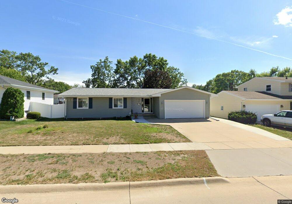
1915 Mcgowan Blvd Marion, IA 52302
Estimated Value: $252,000 - $261,000
4
Beds
2
Baths
1,818
Sq Ft
$142/Sq Ft
Est. Value
About This Home
This home is located at 1915 Mcgowan Blvd, Marion, IA 52302 and is currently estimated at $257,259, approximately $141 per square foot. 1915 Mcgowan Blvd is a home located in Linn County with nearby schools including Wilkins Elementary School, Excelsior Middle School, and Linn-Mar High School.
Ownership History
Date
Name
Owned For
Owner Type
Purchase Details
Closed on
Sep 22, 2011
Sold by
Brenneman Sandra L and The Sandra L Brenneman Revocab
Bought by
Knutsen Larry G and Knutsen Karyn J
Current Estimated Value
Home Financials for this Owner
Home Financials are based on the most recent Mortgage that was taken out on this home.
Original Mortgage
$140,400
Outstanding Balance
$96,007
Interest Rate
4.23%
Mortgage Type
New Conventional
Estimated Equity
$161,252
Create a Home Valuation Report for This Property
The Home Valuation Report is an in-depth analysis detailing your home's value as well as a comparison with similar homes in the area
Home Values in the Area
Average Home Value in this Area
Purchase History
| Date | Buyer | Sale Price | Title Company |
|---|---|---|---|
| Knutsen Larry G | $155,500 | None Available |
Source: Public Records
Mortgage History
| Date | Status | Borrower | Loan Amount |
|---|---|---|---|
| Open | Knutsen Larry G | $140,400 |
Source: Public Records
Tax History Compared to Growth
Tax History
| Year | Tax Paid | Tax Assessment Tax Assessment Total Assessment is a certain percentage of the fair market value that is determined by local assessors to be the total taxable value of land and additions on the property. | Land | Improvement |
|---|---|---|---|---|
| 2025 | $4,298 | $269,600 | $24,300 | $245,300 |
| 2024 | $4,292 | $246,000 | $24,300 | $221,700 |
| 2023 | $4,292 | $246,000 | $24,300 | $221,700 |
| 2022 | $4,090 | $202,300 | $24,300 | $178,000 |
| 2021 | $4,004 | $202,300 | $24,300 | $178,000 |
| 2020 | $4,004 | $186,300 | $24,300 | $162,000 |
| 2019 | $3,718 | $173,300 | $24,300 | $149,000 |
| 2018 | $3,570 | $173,300 | $24,300 | $149,000 |
| 2017 | $3,270 | $151,500 | $24,300 | $127,200 |
| 2016 | $3,270 | $151,500 | $24,300 | $127,200 |
| 2015 | $3,257 | $151,500 | $24,300 | $127,200 |
| 2014 | $3,070 | $151,500 | $24,300 | $127,200 |
| 2013 | $2,928 | $151,500 | $24,300 | $127,200 |
Source: Public Records
Map
Nearby Homes
- 1875 Mcgowan Blvd
- 1945 Mcgowan Blvd
- 1920 Brockman Ave
- 1880 Brockman Ave
- 1950 Brockman Ave
- 1835 Mcgowan Blvd
- 1975 Mcgowan Blvd
- 1920 Mcgowan Blvd
- 1840 Brockman Ave
- 1950 Mcgowan Blvd
- 1980 Brockman Ave
- 1880 Mcgowan Blvd
- 1930 Maplecrest Dr
- 1840 Mcgowan Blvd
- 1800 Brockman Ave
- 1945 Brockman Ave
- 2025 Mcgowan Blvd
- 1800 Mcgowan Blvd
- 1915 Brockman Ave
- 1915 Country Club Dr