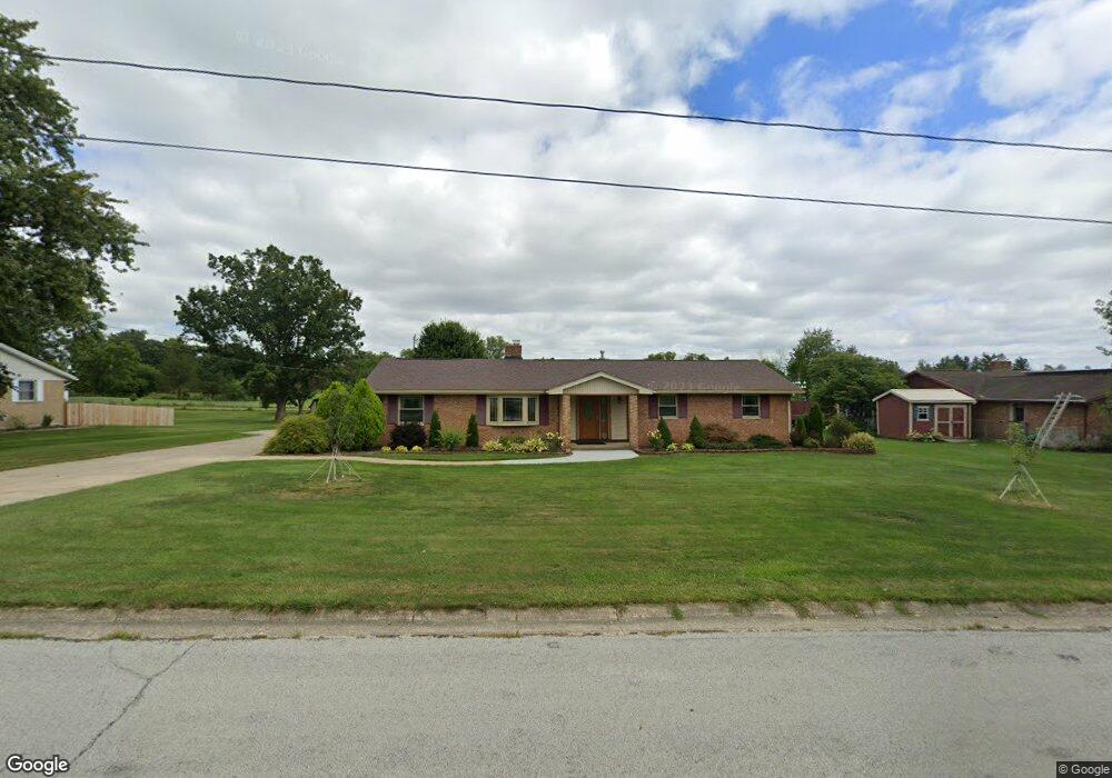
1916 Perkins Dr Springfield, OH 45505
Estimated Value: $269,145 - $346,000
3
Beds
2
Baths
1,736
Sq Ft
$186/Sq Ft
Est. Value
About This Home
This home is located at 1916 Perkins Dr, Springfield, OH 45505 and is currently estimated at $323,536, approximately $186 per square foot. 1916 Perkins Dr is a home located in Clark County with nearby schools including Possum Elementary School, Shawnee Middle School/High School, and Twin Oaks Sda Elementary School.
Ownership History
Date
Name
Owned For
Owner Type
Purchase Details
Closed on
May 31, 2005
Sold by
Estate Of Mary E Neer
Bought by
Neer Donald O
Current Estimated Value
Create a Home Valuation Report for This Property
The Home Valuation Report is an in-depth analysis detailing your home's value as well as a comparison with similar homes in the area
Home Values in the Area
Average Home Value in this Area
Purchase History
| Date | Buyer | Sale Price | Title Company |
|---|---|---|---|
| Neer Donald O | -- | -- |
Source: Public Records
Tax History
| Year | Tax Paid | Tax Assessment Tax Assessment Total Assessment is a certain percentage of the fair market value that is determined by local assessors to be the total taxable value of land and additions on the property. | Land | Improvement |
|---|---|---|---|---|
| 2025 | $3,017 | $91,610 | $15,920 | $75,690 |
| 2024 | $2,967 | $69,880 | $14,470 | $55,410 |
| 2023 | $2,967 | $69,880 | $14,470 | $55,410 |
| 2022 | $2,963 | $69,880 | $14,470 | $55,410 |
| 2021 | $2,180 | $49,000 | $10,340 | $38,660 |
| 2020 | $2,198 | $49,000 | $10,340 | $38,660 |
| 2019 | $2,232 | $49,000 | $10,340 | $38,660 |
| 2018 | $2,275 | $49,210 | $11,580 | $37,630 |
| 2017 | $2,334 | $49,413 | $11,578 | $37,835 |
| 2016 | $2,106 | $49,413 | $11,578 | $37,835 |
| 2015 | $1,745 | $43,835 | $10,336 | $33,499 |
| 2014 | $1,750 | $43,835 | $10,336 | $33,499 |
| 2013 | $1,521 | $43,835 | $10,336 | $33,499 |
Source: Public Records
Map
Nearby Homes
- 2076-2078 Stowe Dr
- 2224 Cheviot Hills Dr
- 2208 Hackberry St
- 2210 Hackberry St
- 2214 Hackberry St
- 2216 Hackberry St
- 2207 Hackberry St
- 2209 Hackberry St
- 2211 Hackberry St
- 2215 Hackberry St
- 2809 Morton Dr
- 1011 Mount Joy St
- 631 Kramer Rd
- 2037 Gerald Dr
- 2745 Share St
- 2040 N Hadley Rd
- 2108 Sunset Ave
- 451 Lawnview Ave
- 1724 S Belmont Ave
- 2804 Lowman St
- 1908 Perkins Dr
- 1926 Perkins Dr
- 1850 Perkins Dr
- 2000 Perkins Dr
- 1919 Perkins Dr
- 1911 Perkins Dr
- 1931 Perkins Dr
- 1842 Perkins Dr
- 1861 Perkins Dr
- 2030 Perkins Dr
- 2005 Perkins Dr
- 1833 Perkins Dr
- 1820 Perkins Dr
- 3040 Broadview Dr
- 2050 Perkins Dr
- 1809 Cheviot Hills Dr
- 1908 Cheviot Hills Dr
- 1916 Cheviot Hills Dr
- 1900 Cheviot Hills Dr
- 1928 Cheviot Hills Dr
Your Personal Tour Guide
Ask me questions while you tour the home.