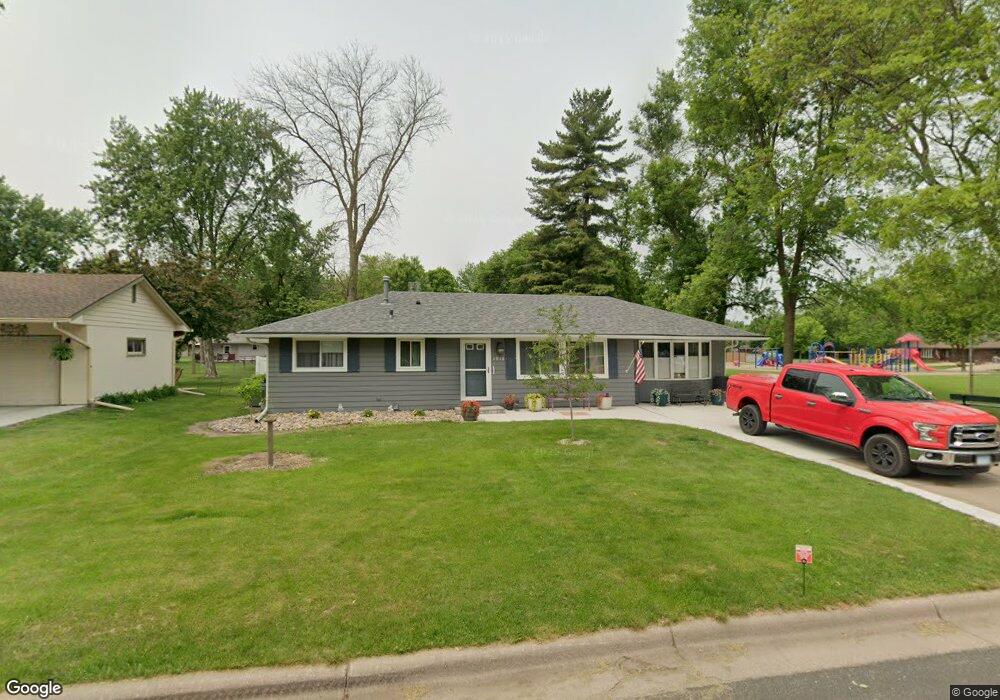
1916 Walnut St Hastings, MN 55033
Hastings-Marshan Township NeighborhoodEstimated Value: $326,630 - $362,000
3
Beds
2
Baths
3,140
Sq Ft
$110/Sq Ft
Est. Value
About This Home
This home is located at 1916 Walnut St, Hastings, MN 55033 and is currently estimated at $346,158, approximately $110 per square foot. 1916 Walnut St is a home located in Dakota County with nearby schools including Pinecrest Elementary School, Hastings Middle School, and Hastings High School.
Ownership History
Date
Name
Owned For
Owner Type
Purchase Details
Closed on
Nov 6, 2020
Sold by
Larson Kory B
Bought by
Mapes David E and Mapes Linda J
Current Estimated Value
Home Financials for this Owner
Home Financials are based on the most recent Mortgage that was taken out on this home.
Original Mortgage
$280,250
Interest Rate
2.8%
Mortgage Type
New Conventional
Purchase Details
Closed on
Sep 5, 2014
Sold by
Flom Ethel M
Bought by
Larson Kory B
Home Financials for this Owner
Home Financials are based on the most recent Mortgage that was taken out on this home.
Original Mortgage
$115,000
Interest Rate
4.1%
Mortgage Type
New Conventional
Create a Home Valuation Report for This Property
The Home Valuation Report is an in-depth analysis detailing your home's value as well as a comparison with similar homes in the area
Home Values in the Area
Average Home Value in this Area
Purchase History
| Date | Buyer | Sale Price | Title Company |
|---|---|---|---|
| Mapes David E | $295,000 | Dca Title | |
| Larson Kory B | $170,000 | Kandiyohi Abstract & Title C | |
| Mapes David David | $295,000 | -- |
Source: Public Records
Mortgage History
| Date | Status | Borrower | Loan Amount |
|---|---|---|---|
| Previous Owner | Mapes David E | $280,250 | |
| Previous Owner | Larson Kory B | $115,000 | |
| Closed | Mapes David David | $280,250 |
Source: Public Records
Tax History
| Year | Tax Paid | Tax Assessment Tax Assessment Total Assessment is a certain percentage of the fair market value that is determined by local assessors to be the total taxable value of land and additions on the property. | Land | Improvement |
|---|---|---|---|---|
| 2024 | $3,562 | $304,600 | $70,700 | $233,900 |
| 2023 | $3,562 | $315,600 | $70,700 | $244,900 |
| 2022 | $2,866 | $300,500 | $70,600 | $229,900 |
| 2021 | $2,828 | $245,100 | $58,500 | $186,600 |
| 2020 | $2,736 | $240,700 | $55,700 | $185,000 |
| 2019 | $2,635 | $226,800 | $53,000 | $173,800 |
| 2018 | $2,471 | $209,600 | $50,500 | $159,100 |
| 2017 | $2,312 | $192,500 | $48,100 | $144,400 |
| 2016 | $2,310 | $181,500 | $45,000 | $136,500 |
| 2015 | $2,105 | $156,126 | $38,371 | $117,755 |
| 2014 | -- | $142,610 | $36,301 | $106,309 |
| 2013 | -- | $124,080 | $31,858 | $92,222 |
Source: Public Records
Map
Nearby Homes
- 1930 Maple St
- 1942 Eddy St
- 640 S Park Ct
- 864 S Park Dr
- 909 14th St W
- 1680 Louis Ln
- 812 13th St W
- 1321 Sibley St
- 532 17th St E
- 1079 S Pointe Dr
- 1168 Sherman Way
- 907 Pine St
- 3525 Vermillion St
- 3575 Vermillion St
- 561 Marmik Cir
- 1021 Bailey St
- 471 Frederick Cir Unit 1503
- 2168 Westpointe Dr
- 1017 Bailly St
- 922 Ramsey St
- 1916 1916 Walnut St
- 1922 Walnut St
- 1917 Maple St
- 1923 Maple St
- 1926 Walnut St
- 1917 Walnut St
- 1927 Maple St
- 1921 Walnut St
- 1911 Walnut St
- 1911 1911 Walnut St
- 1930 Walnut St
- 1927 Walnut St
- 1931 Maple St
- 509 19th St W
- 1931 Walnut St
- 1934 Walnut St
- 604 19th St W
- 610 19th St W
- 1910 Maple St
- 1928 Forest St
Your Personal Tour Guide
Ask me questions while you tour the home.