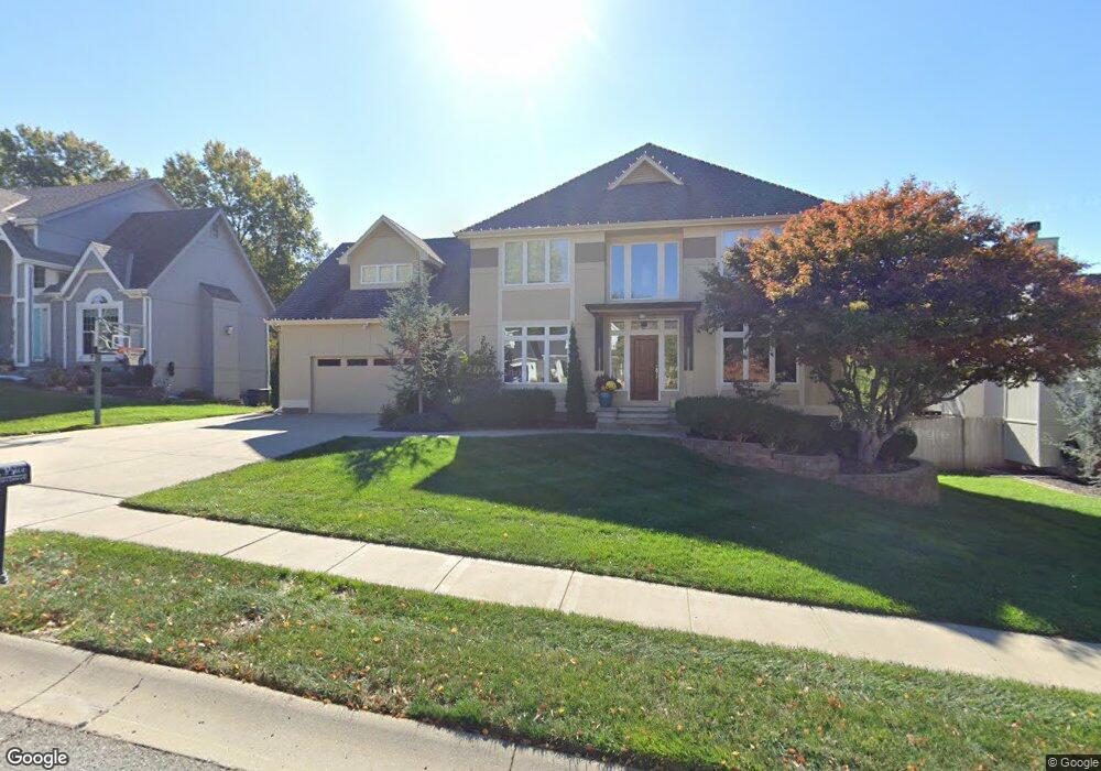
1917 High Dr Liberty, MO 64068
Estimated Value: $487,000 - $564,000
4
Beds
3
Baths
2,764
Sq Ft
$189/Sq Ft
Est. Value
About This Home
This home is located at 1917 High Dr, Liberty, MO 64068 and is currently estimated at $523,565, approximately $189 per square foot. 1917 High Dr is a home located in Clay County with nearby schools including Alexander Doniphan Elementary School, Discovery Middle School, and Liberty High School.
Ownership History
Date
Name
Owned For
Owner Type
Purchase Details
Closed on
Sep 1, 2016
Sold by
Price Michelle A
Bought by
Price Michelle A and Price Jeffrey C
Current Estimated Value
Purchase Details
Closed on
Sep 2, 1999
Sold by
Hallak Pamela A and Hallak Bradley D
Bought by
Price Jeffrey Carson and Price Michelle Ann
Purchase Details
Closed on
Dec 31, 1998
Sold by
Hallak Bradley D and Hallak Pamela A
Bought by
Hallak Pamela A and Hallak Bradley D
Purchase Details
Closed on
Dec 22, 1998
Sold by
Peterson Development Company Inc
Bought by
Hallak Bradley D and Hallak Pamela A
Create a Home Valuation Report for This Property
The Home Valuation Report is an in-depth analysis detailing your home's value as well as a comparison with similar homes in the area
Home Values in the Area
Average Home Value in this Area
Purchase History
| Date | Buyer | Sale Price | Title Company |
|---|---|---|---|
| Price Michelle A | -- | None Available | |
| Price Michelle A | -- | None Available | |
| Price Jeffrey Carson | -- | United Title Company | |
| Hallak Pamela A | -- | United Title Company | |
| Hallak Bradley D | -- | United Title Company |
Source: Public Records
Tax History Compared to Growth
Tax History
| Year | Tax Paid | Tax Assessment Tax Assessment Total Assessment is a certain percentage of the fair market value that is determined by local assessors to be the total taxable value of land and additions on the property. | Land | Improvement |
|---|---|---|---|---|
| 2025 | $6,191 | $89,000 | -- | -- |
| 2024 | $6,191 | $80,500 | -- | -- |
| 2023 | $6,296 | $80,500 | $0 | $0 |
| 2022 | $5,567 | $70,280 | $0 | $0 |
| 2021 | $5,524 | $70,281 | $7,600 | $62,681 |
| 2020 | $5,401 | $64,520 | $0 | $0 |
| 2019 | $5,399 | $64,520 | $0 | $0 |
| 2018 | $4,909 | $57,590 | $0 | $0 |
| 2017 | $4,736 | $57,590 | $5,700 | $51,890 |
| 2016 | $4,736 | $56,090 | $5,700 | $50,390 |
| 2015 | $4,737 | $56,090 | $5,700 | $50,390 |
| 2014 | $4,178 | $49,080 | $5,320 | $43,760 |
Source: Public Records
Map
Nearby Homes
- 1124 Amesbury Ave
- 415 Monterey Ave
- 1323 Amesbury Ave
- 509 Belmont St
- 420 Belmont St
- 1218 Canterbury Ln
- 1507 Amesbury Ave
- 918 Amesbury Ave
- 862 Amesbury Ave
- 1733 Welleslay Ln
- 1537 Canterbury Ln
- 716 Bristol Ct
- 1331 Park Ln
- 1317 Park Ln
- 1304 Wellington Way
- 1327 Easton Ct
- 1209 Liberty Drive Terrace
- 253 S Stewart Rd
- 1205 Blackberry Dr
- 2116 Winding Woods Dr