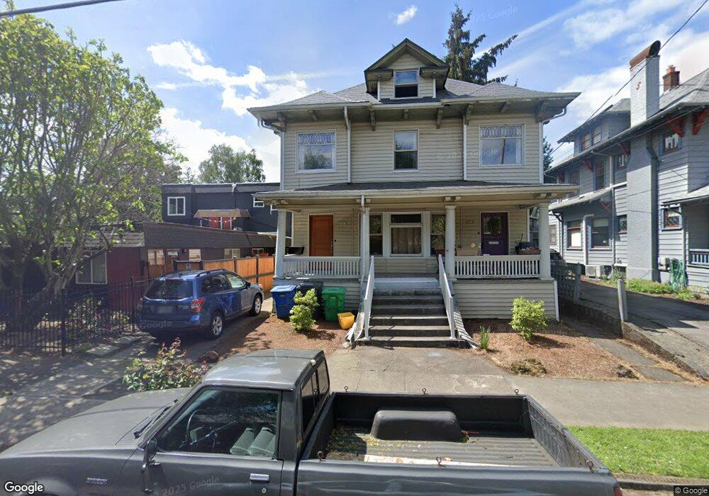
1917 NE 10th Ave Unit 1919 Portland, OR 97212
Lloyd District NeighborhoodEstimated Value: $811,000 - $857,000
4
Beds
2
Baths
3,438
Sq Ft
$240/Sq Ft
Est. Value
About This Home
This home is located at 1917 NE 10th Ave Unit 1919, Portland, OR 97212 and is currently estimated at $823,959, approximately $239 per square foot. 1917 NE 10th Ave Unit 1919 is a home located in Multnomah County with nearby schools including Irvington Elementary School, Harriet Tubman Middle School, and Jefferson High School.
Ownership History
Date
Name
Owned For
Owner Type
Purchase Details
Closed on
Aug 26, 2025
Sold by
Reid Megan Patricia and Reid Megan Still
Bought by
Notre Dame Properties Llc
Current Estimated Value
Home Financials for this Owner
Home Financials are based on the most recent Mortgage that was taken out on this home.
Original Mortgage
$790,000
Outstanding Balance
$790,000
Interest Rate
6.75%
Mortgage Type
New Conventional
Estimated Equity
$33,959
Purchase Details
Closed on
May 14, 2012
Sold by
Still Kevin D
Bought by
Reid Megan Patricia
Create a Home Valuation Report for This Property
The Home Valuation Report is an in-depth analysis detailing your home's value as well as a comparison with similar homes in the area
Home Values in the Area
Average Home Value in this Area
Purchase History
| Date | Buyer | Sale Price | Title Company |
|---|---|---|---|
| Notre Dame Properties Llc | $810,000 | Fidelity National Title | |
| Reid Megan Patricia | -- | None Available |
Source: Public Records
Mortgage History
| Date | Status | Borrower | Loan Amount |
|---|---|---|---|
| Open | Notre Dame Properties Llc | $790,000 |
Source: Public Records
Tax History Compared to Growth
Tax History
| Year | Tax Paid | Tax Assessment Tax Assessment Total Assessment is a certain percentage of the fair market value that is determined by local assessors to be the total taxable value of land and additions on the property. | Land | Improvement |
|---|---|---|---|---|
| 2025 | $8,765 | $325,310 | -- | -- |
| 2024 | $8,450 | $315,840 | -- | -- |
| 2023 | $8,126 | $306,650 | $0 | $0 |
| 2022 | $7,950 | $297,720 | $0 | $0 |
| 2021 | $7,815 | $289,050 | $0 | $0 |
| 2020 | $7,170 | $280,640 | $0 | $0 |
| 2019 | $6,906 | $272,470 | $0 | $0 |
| 2018 | $6,703 | $264,540 | $0 | $0 |
| 2017 | $6,424 | $256,840 | $0 | $0 |
| 2016 | $5,879 | $249,360 | $0 | $0 |
| 2015 | $5,725 | $242,100 | $0 | $0 |
| 2014 | $5,639 | $235,050 | $0 | $0 |
Source: Public Records
Map
Nearby Homes
- 2013 NE 10th Ave Unit E
- 1102 NE Tillamook St Unit 5
- 1912 NE 11th Ave
- 2223 NE 9th Ave
- 1805 NE 8th Ave
- 1718 NE 11th Ave Unit 313
- 1010 NE Weidler St Unit 1016
- 522 NE Sacramento St
- 1927 NE 16th Ave
- 1620 NE Broadway St Unit 206
- 1620 NE Broadway St Unit 540
- 1620 NE Broadway St Unit 232
- 131 NE Tillamook St
- 502 NE Knott St
- 1408 NE Knott St
- 533 NE Holladay St Unit 605
- 533 NE Holladay St Unit 601
- 533 NE Holladay St Unit 308
- 2845 NE Martin Luther King Junior Blvd
- 1220 NE 17th Ave Unit 12B
- 1927 NE 10th Ave Unit 1929
- 927 NE Hancock St Unit 933
- 2003 NE 10th Ave
- 1916 NE 9th Ave
- 1922 NE 9th Ave
- 1904 NE 9th Ave
- 1910 NE 10th Ave Unit 1916
- 2004 NE 9th Ave
- 2013 NE 10th Ave Unit D
- 2013 NE 10th Ave Unit C
- 2013 NE 10th Ave Unit B
- 2013 NE 10th Ave Unit 1
- 2013 NE 10th Ave Unit 5
- 2013 NE 10th Ave Unit 4
- 2013 NE 10th Ave Unit 3
- 2013 NE 10th Ave Unit 2
- 2015 NE 10th Ave Unit 3
- 2015 NE 10th Ave Unit 2
- 2015 NE 10th Ave Unit 4
- 2015 NE 10th Ave Unit 1