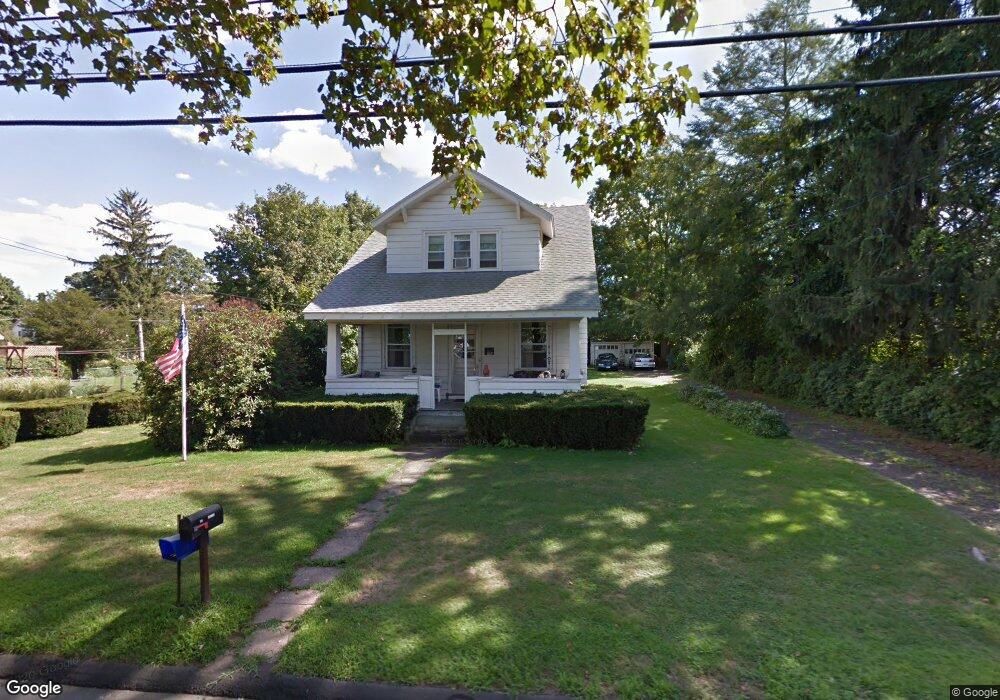
192 Prout Hill Rd Middletown, CT 06457
Estimated Value: $323,000 - $348,000
3
Beds
1
Bath
1,453
Sq Ft
$228/Sq Ft
Est. Value
About This Home
This home is located at 192 Prout Hill Rd, Middletown, CT 06457 and is currently estimated at $331,811, approximately $228 per square foot. 192 Prout Hill Rd is a home located in Middlesex County with nearby schools including Farm Hill School, Middletown High School, and St John Paul II School.
Ownership History
Date
Name
Owned For
Owner Type
Purchase Details
Closed on
May 28, 2024
Sold by
Carlson James L and Carlson Ann A
Bought by
Laure Joshua and Warzecha Amy
Current Estimated Value
Home Financials for this Owner
Home Financials are based on the most recent Mortgage that was taken out on this home.
Original Mortgage
$250,000
Outstanding Balance
$245,748
Interest Rate
7.1%
Mortgage Type
Purchase Money Mortgage
Estimated Equity
$86,063
Create a Home Valuation Report for This Property
The Home Valuation Report is an in-depth analysis detailing your home's value as well as a comparison with similar homes in the area
Home Values in the Area
Average Home Value in this Area
Purchase History
| Date | Buyer | Sale Price | Title Company |
|---|---|---|---|
| Laure Joshua | $285,000 | None Available | |
| Laure Joshua | $285,000 | None Available |
Source: Public Records
Mortgage History
| Date | Status | Borrower | Loan Amount |
|---|---|---|---|
| Open | Laure Joshua | $250,000 | |
| Closed | Laure Joshua | $250,000 |
Source: Public Records
Tax History
| Year | Tax Paid | Tax Assessment Tax Assessment Total Assessment is a certain percentage of the fair market value that is determined by local assessors to be the total taxable value of land and additions on the property. | Land | Improvement |
|---|---|---|---|---|
| 2025 | $6,320 | $170,750 | $71,760 | $98,990 |
| 2024 | $6,046 | $170,750 | $71,760 | $98,990 |
| 2023 | $5,739 | $170,750 | $71,760 | $98,990 |
| 2022 | $4,942 | $119,780 | $47,840 | $71,940 |
| 2021 | $4,920 | $119,780 | $47,840 | $71,940 |
| 2020 | $4,911 | $119,780 | $47,840 | $71,940 |
| 2019 | $4,935 | $119,780 | $47,840 | $71,940 |
| 2018 | $4,765 | $119,780 | $47,840 | $71,940 |
| 2017 | $4,885 | $126,280 | $58,120 | $68,160 |
| 2016 | $4,787 | $126,280 | $58,120 | $68,160 |
| 2015 | $4,681 | $126,280 | $58,120 | $68,160 |
| 2014 | $4,676 | $126,280 | $58,120 | $68,160 |
Source: Public Records
Map
Nearby Homes
- 909 Randolph Rd
- 50 Cedar St
- 63 Millbrook Rd
- 7 Countryside Ln Unit 4
- 1 Jefferson Ave
- 28 Kent Ct
- Lot 3 Coleman Rd
- 180 Randolph Rd
- 122 Baldwin Dr
- 6 Hillside Ct
- 6 Bidwell Terrace
- 58 Durant Terrace
- 70 Jack English Dr
- Lot 2 Coleman Rd
- 15 Blue Spruce St
- 42 Saybrook Rd
- 7 Blue Bell Ln
- 37 Dobson Cir
- 5 Wall St
- 678 Bartholomew Rd
- 182 Prout Hill Rd
- 212 Prout Hill Rd
- 15 Trailside Crossing
- 796 Ridge Rd
- 790 Ridge Rd
- 222 Prout Hill Rd
- 25 Trailside Crossing
- 166 Prout Hill Rd
- 6 Columbine Rd
- 30 Trailside Crossing
- 797 Ridge Rd
- 0 Trailside Crossing
- 240 Prout Hill Rd
- 787 Ridge Rd
- 776 Ridge Rd
- 6R Prout Hill Rd
- 6 Prout Hill Rd
- 45 Trailside Crossing
- 779 Ridge Rd
- 241 Prout Hill Rd
Your Personal Tour Guide
Ask me questions while you tour the home.