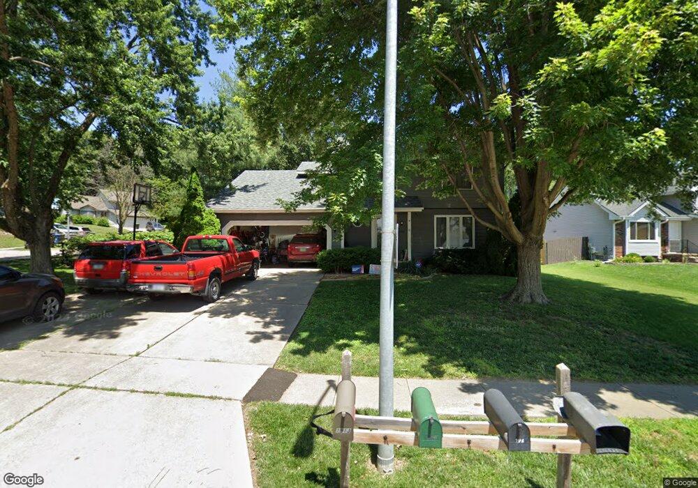
1920 E Maish Ave Des Moines, IA 50320
Ewing Woods-Evergreen NeighborhoodEstimated Value: $276,000 - $308,000
3
Beds
3
Baths
1,697
Sq Ft
$170/Sq Ft
Est. Value
About This Home
This home is located at 1920 E Maish Ave, Des Moines, IA 50320 and is currently estimated at $288,076, approximately $169 per square foot. 1920 E Maish Ave is a home located in Polk County with nearby schools including Jackson Elementary School, Weeks Middle School, and East High School.
Ownership History
Date
Name
Owned For
Owner Type
Purchase Details
Closed on
Nov 22, 2002
Sold by
Pals Robert and Pals Dana
Bought by
Coco Christopher C and Coco Diana
Current Estimated Value
Home Financials for this Owner
Home Financials are based on the most recent Mortgage that was taken out on this home.
Original Mortgage
$126,000
Outstanding Balance
$54,636
Interest Rate
6.5%
Estimated Equity
$233,440
Purchase Details
Closed on
Jun 30, 1998
Sold by
Meyer Larry C and Meyer Kathleen R
Bought by
Pals Robert and Pals Dana
Home Financials for this Owner
Home Financials are based on the most recent Mortgage that was taken out on this home.
Original Mortgage
$114,111
Interest Rate
7.15%
Mortgage Type
FHA
Create a Home Valuation Report for This Property
The Home Valuation Report is an in-depth analysis detailing your home's value as well as a comparison with similar homes in the area
Home Values in the Area
Average Home Value in this Area
Purchase History
| Date | Buyer | Sale Price | Title Company |
|---|---|---|---|
| Coco Christopher C | $139,500 | -- | |
| Pals Robert | $119,500 | -- |
Source: Public Records
Mortgage History
| Date | Status | Borrower | Loan Amount |
|---|---|---|---|
| Open | Coco Christopher C | $126,000 | |
| Previous Owner | Pals Robert | $114,111 |
Source: Public Records
Tax History
| Year | Tax Paid | Tax Assessment Tax Assessment Total Assessment is a certain percentage of the fair market value that is determined by local assessors to be the total taxable value of land and additions on the property. | Land | Improvement |
|---|---|---|---|---|
| 2025 | $4,648 | $281,000 | $46,800 | $234,200 |
| 2024 | $4,648 | $253,700 | $41,600 | $212,100 |
| 2023 | $4,744 | $253,700 | $41,600 | $212,100 |
| 2022 | $4,706 | $210,200 | $35,300 | $174,900 |
| 2021 | $4,476 | $210,200 | $35,300 | $174,900 |
| 2020 | $4,646 | $188,000 | $31,600 | $156,400 |
| 2019 | $4,022 | $188,000 | $31,600 | $156,400 |
| 2018 | $3,976 | $158,200 | $25,800 | $132,400 |
| 2017 | $3,664 | $158,200 | $25,800 | $132,400 |
| 2016 | $3,564 | $144,000 | $23,200 | $120,800 |
| 2015 | $3,564 | $144,000 | $23,200 | $120,800 |
| 2014 | $3,492 | $145,300 | $23,400 | $121,900 |
Source: Public Records
Map
Nearby Homes
- 3619 SE 20th St
- 4010 SE 22nd St
- 4137 SE 22nd St
- 4225 SE 22nd St
- 3307 SE 19th St
- 4401 SW 23rd St
- 2220 E Rose Ave
- 1626 Evergreen Ave
- 1834 E Park Ave
- 1600 Evergreen Ave
- 3101 SE 22nd St
- 4280 SE 15th Ct
- 3800 SE 25th Ct
- 2236 Riverwoods Ave
- 1943 E Bell Ave
- 2618 SE 18th Ct
- 2811 SE 22nd St Unit 240
- 2811 SE 22nd St Unit 930
- 2811 SE 22nd St Unit 220
- 1437 E Pleasant View Dr
- 1926 E Maish Ave
- 3713 SE 19th Ct
- 1930 E Maish Ave
- 3724 SE 19th Ct
- 1925 E Maish Ave
- 1913 E Maish Ave
- 3707 SE 19th Ct
- 3718 SE 19th Ct
- 3718 SE 20th St
- 3706 SE 19th Ct
- 1907 E Maish Ave
- 3712 SE 19th Ct
- 3712 SE 20th St
- 1933 E Maish Ave
- 3706 SE 20th St
- 1919 E Rose Ave
- 1950 Windsor Ct
- 1913 E Rose Ave
- 2000 E Maish Ave
- 1960 Windsor Ct
Your Personal Tour Guide
Ask me questions while you tour the home.