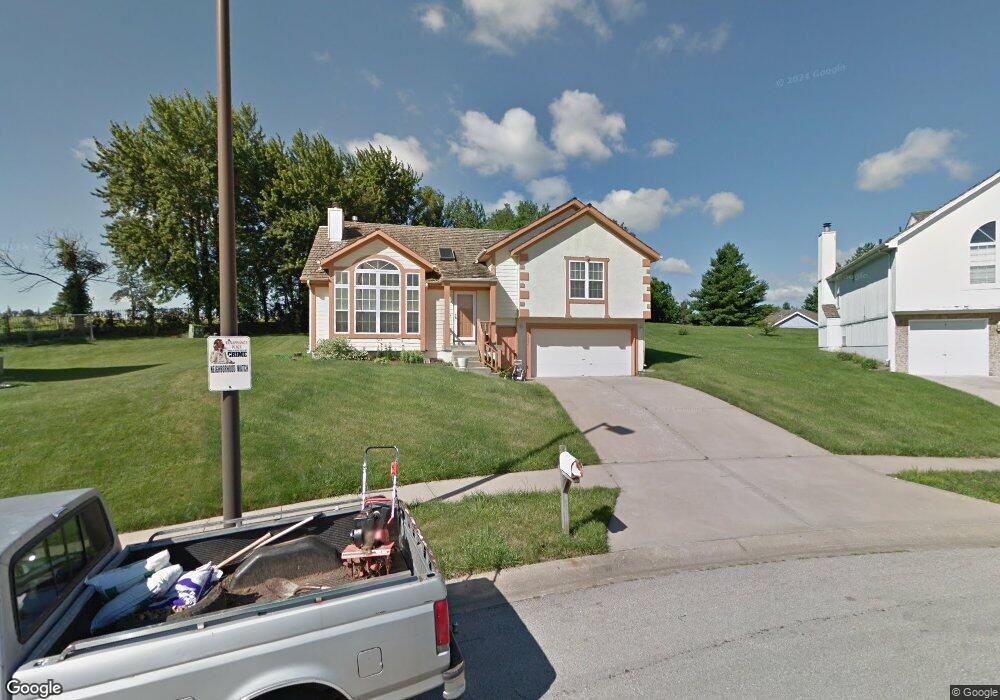
1920 Norton Ave Kansas City, MO 64127
West Blue Valley NeighborhoodEstimated Value: $218,943 - $287,000
3
Beds
2
Baths
1,449
Sq Ft
$173/Sq Ft
Est. Value
About This Home
This home is located at 1920 Norton Ave, Kansas City, MO 64127 and is currently estimated at $251,236, approximately $173 per square foot. 1920 Norton Ave is a home located in Jackson County with nearby schools including Phillis Wheatley Elementary School, Central Middle School, and East High School.
Ownership History
Date
Name
Owned For
Owner Type
Purchase Details
Closed on
Nov 14, 2002
Sold by
Locke Bankston Deborah K and Locke Deborah K
Bought by
Locke Bankston Deborah K
Current Estimated Value
Home Financials for this Owner
Home Financials are based on the most recent Mortgage that was taken out on this home.
Original Mortgage
$108,000
Interest Rate
5.89%
Mortgage Type
Purchase Money Mortgage
Create a Home Valuation Report for This Property
The Home Valuation Report is an in-depth analysis detailing your home's value as well as a comparison with similar homes in the area
Home Values in the Area
Average Home Value in this Area
Purchase History
| Date | Buyer | Sale Price | Title Company |
|---|---|---|---|
| Locke Bankston Deborah K | -- | -- |
Source: Public Records
Mortgage History
| Date | Status | Borrower | Loan Amount |
|---|---|---|---|
| Closed | Locke Bankston Deborah K | $108,000 |
Source: Public Records
Tax History Compared to Growth
Tax History
| Year | Tax Paid | Tax Assessment Tax Assessment Total Assessment is a certain percentage of the fair market value that is determined by local assessors to be the total taxable value of land and additions on the property. | Land | Improvement |
|---|---|---|---|---|
| 2025 | $2,865 | $27,138 | $8,406 | $18,732 |
| 2024 | $2,838 | $36,307 | $19,101 | $17,206 |
| 2023 | $2,838 | $36,307 | $4,013 | $32,294 |
| 2022 | $1,688 | $20,520 | $4,199 | $16,321 |
| 2021 | $1,682 | $20,520 | $4,199 | $16,321 |
| 2020 | $1,487 | $17,911 | $4,199 | $13,712 |
| 2019 | $1,456 | $17,911 | $4,199 | $13,712 |
| 2018 | $1,427 | $17,922 | $3,844 | $14,078 |
| 2017 | $1,399 | $17,922 | $3,844 | $14,078 |
| 2016 | $1,399 | $17,473 | $2,005 | $15,468 |
| 2014 | $1,403 | $17,473 | $2,005 | $15,468 |
Source: Public Records
Map
Nearby Homes
- 1800 E 24th St
- 1807 Kensington Ave
- 2243 Spruce Ave
- 1812 Elmwood Ave
- 2201 Askew Ave
- 2319 Norton Ave
- 3113 E 19th St
- 3111 E 19th St
- 4701 E Truman Rd
- 2410 Myrtle Ave
- 4711 E 17th St
- 3301 E 20th Terrace
- 2406 Kensington Ave
- 3210 E 20th St
- 4819 E 17th St
- 2424 Cypress Ave
- 3318 E 24th St
- 4900 E 23rd St
- 3009 E 19th Terrace
- 2512 Mersington Ave
- 1923 Norton Ave
- 1916 Norton Ave
- 1912 Norton Ave
- 1917 Myrtle Ave
- 1911 Norton Ave
- 1907 Norton Ave
- 1913 Myrtle Ave
- 1921 Myrtle Ave
- 1904 Norton Ave
- 1909 Myrtle Ave
- 1920 Myrtle Ave
- 4101 E 19th St
- 4105 E 19th St
- 1905 Myrtle Ave
- 1916 Myrtle Ave
- 1908 Myrtle Ave
- 4109 E 19th St
- 1931 Jackson Ave
- 1927 Jackson Ave
- 1923 Jackson Ave