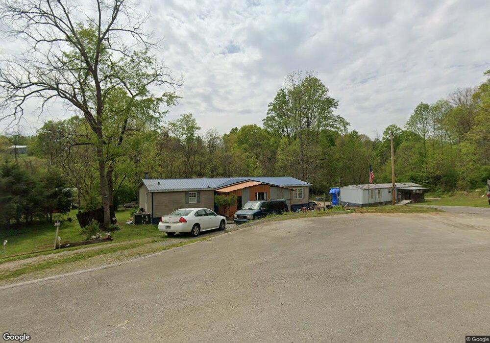
1921 Brookside Dr Morristown, TN 37813
Estimated Value: $209,000 - $226,000
3
Beds
2
Baths
1,792
Sq Ft
$121/Sq Ft
Est. Value
About This Home
This home is located at 1921 Brookside Dr, Morristown, TN 37813 and is currently estimated at $217,500, approximately $121 per square foot. 1921 Brookside Dr is a home located in Hamblen County with nearby schools including Witt Elementary School, Lincoln Heights Middle School, and Morristown West High School.
Ownership History
Date
Name
Owned For
Owner Type
Purchase Details
Closed on
Dec 29, 2020
Sold by
Vandercook Charles and Vandercook Barbara
Bought by
Estep Michelle
Current Estimated Value
Purchase Details
Closed on
Nov 1, 2012
Sold by
Hughes Mack
Bought by
Estep Deborah
Purchase Details
Closed on
Apr 7, 2010
Sold by
Jaynes Joseph L
Bought by
Hughes Mack
Purchase Details
Closed on
Feb 13, 2004
Bought by
Jaynes Joseph and Jaynes Elizabeth
Purchase Details
Closed on
Jul 17, 2003
Bought by
Dickerson David M
Purchase Details
Closed on
Oct 4, 1973
Bought by
Wood Wayne A
Create a Home Valuation Report for This Property
The Home Valuation Report is an in-depth analysis detailing your home's value as well as a comparison with similar homes in the area
Home Values in the Area
Average Home Value in this Area
Purchase History
| Date | Buyer | Sale Price | Title Company |
|---|---|---|---|
| Estep Michelle | $4,000 | Estep Deborah | |
| Estep Deborah | $6,500 | -- | |
| Hughes Mack | $6,500 | -- | |
| Jaynes Joseph | -- | -- | |
| Dickerson David M | -- | -- | |
| Wood Wayne A | -- | -- |
Source: Public Records
Tax History Compared to Growth
Tax History
| Year | Tax Paid | Tax Assessment Tax Assessment Total Assessment is a certain percentage of the fair market value that is determined by local assessors to be the total taxable value of land and additions on the property. | Land | Improvement |
|---|---|---|---|---|
| 2024 | $506 | $25,675 | $4,250 | $21,425 |
| 2023 | $506 | $25,675 | $0 | $0 |
| 2022 | $458 | $23,250 | $4,250 | $19,000 |
| 2021 | $458 | $23,250 | $4,250 | $19,000 |
| 2020 | $458 | $23,250 | $4,250 | $19,000 |
| 2019 | $366 | $17,200 | $2,725 | $14,475 |
| 2018 | $366 | $17,200 | $2,725 | $14,475 |
| 2017 | $366 | $17,200 | $2,725 | $14,475 |
| 2016 | $342 | $17,200 | $2,725 | $14,475 |
| 2015 | $318 | $17,200 | $2,725 | $14,475 |
| 2014 | -- | $17,200 | $2,725 | $14,475 |
| 2013 | -- | $20,525 | $0 | $0 |
Source: Public Records
Map
Nearby Homes
- 1418 Mae Collins Rd
- 1160 Statem Gap Rd
- 2018 Southwood Cir
- Darwin Plan at Southwood
- Robie Plan at Southwood
- Elston Plan at Southwood
- Belhaven Plan at Southwood
- Penwell Plan at Southwood
- Cali Plan at Southwood
- 1049 Greenway Dr
- 203 Lincoln Ave
- 453 Statem Gap Rd
- 440 S Fairmont Ave
- 2895 Coffey Rd
- 837 Pauline Ave
- 305-365 Barkley Landing Dr
- 731 Lennie Ave
- 900 Baird Ave
- 811 Crescent St
- 323 Pauline Ave
- 1927 Brookside Dr
- 1900 Brookside Dr
- 1924 Brookside Dr
- 1935 Brookside Dr
- 1941 Brookside Dr
- 1962 Brookside Dr
- 1840 Claude Collins Rd
- 1971 Brookside Dr
- 2160 Sulphur Springs Rd
- 1918 Misty Wood Dr
- 1910 Misty Wood Dr
- 1980 Brookside Dr
- 1981 Brookside Dr
- 1906 Claude Collins Rd
- 1996 Brookside Dr
- 2128 Sulphur Springs Rd
- 2118 Sulphur Springs Rd
- 2122 Sulphur Springs Rd
- 2152 Sulphur Springs Rd
- 2096 Sulphur Springs Rd