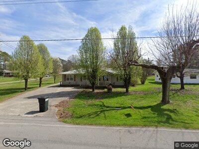
1921 Peavine Rd Rock Spring, GA 30739
Rock Spring NeighborhoodEstimated Value: $176,000 - $211,000
--
Bed
1
Bath
1,128
Sq Ft
$169/Sq Ft
Est. Value
About This Home
This home is located at 1921 Peavine Rd, Rock Spring, GA 30739 and is currently estimated at $191,020, approximately $169 per square foot. 1921 Peavine Rd is a home located in Walker County with nearby schools including Rock Spring Elementary School and Lafayette High School.
Ownership History
Date
Name
Owned For
Owner Type
Purchase Details
Closed on
Aug 8, 2024
Sold by
Mount Michael Eugene
Bought by
Abbott Jaden O and Teeters Alyson J
Current Estimated Value
Home Financials for this Owner
Home Financials are based on the most recent Mortgage that was taken out on this home.
Original Mortgage
$156,030
Outstanding Balance
$155,768
Interest Rate
6.89%
Mortgage Type
New Conventional
Purchase Details
Closed on
Apr 27, 2019
Sold by
Mount Leroy
Bought by
Mount James Gregory
Purchase Details
Closed on
Jan 1, 1972
Bought by
Mount Leroy
Create a Home Valuation Report for This Property
The Home Valuation Report is an in-depth analysis detailing your home's value as well as a comparison with similar homes in the area
Home Values in the Area
Average Home Value in this Area
Purchase History
| Date | Buyer | Sale Price | Title Company |
|---|---|---|---|
| Abbott Jaden O | $170,000 | -- | |
| Mount James Gregory | -- | -- | |
| Mount Leroy | -- | -- |
Source: Public Records
Mortgage History
| Date | Status | Borrower | Loan Amount |
|---|---|---|---|
| Open | Abbott Jaden O | $156,030 | |
| Previous Owner | Mount Leroy | $17,665 |
Source: Public Records
Tax History Compared to Growth
Tax History
| Year | Tax Paid | Tax Assessment Tax Assessment Total Assessment is a certain percentage of the fair market value that is determined by local assessors to be the total taxable value of land and additions on the property. | Land | Improvement |
|---|---|---|---|---|
| 2024 | $1,672 | $74,566 | $7,044 | $67,522 |
| 2023 | $1,598 | $69,484 | $5,591 | $63,893 |
| 2022 | $1,482 | $58,939 | $4,152 | $54,787 |
| 2021 | $1,140 | $39,922 | $4,152 | $35,770 |
| 2020 | $969 | $32,064 | $4,152 | $27,912 |
| 2019 | $115 | $32,064 | $4,152 | $27,912 |
| 2018 | $848 | $32,064 | $4,152 | $27,912 |
| 2017 | $227 | $32,064 | $4,152 | $27,912 |
| 2016 | $133 | $32,064 | $4,152 | $27,912 |
| 2015 | $133 | $29,228 | $6,600 | $22,628 |
| 2014 | $68 | $29,228 | $6,600 | $22,628 |
| 2013 | -- | $29,228 | $6,600 | $22,628 |
Source: Public Records
Map
Nearby Homes
- 15 W Acorn Dr
- 50 Windy Oak Dr
- 34 E Acorn Dr
- 344 Twelve Oaks Dr
- 55 E Acorn Dr
- 1590 Peavine Rd
- 642 E Long Hollow Rd
- 420 Long Hollow Rd
- 1121 Arnold Rd
- 0 N Highway 27
- 183 Long Hollow Rd
- 1476 Arnold Rd
- 183 Long Hollow Rd
- 139 Old Highway 27
- 72 Crest Dr
- 81 Arnold Rd
- 186 Henry Dr
- 56 Deer Ridge Ln
- 200 Hunting Ridge Cir
- 494 Goodson Cir
- 1921 Peavine Rd
- 1938 Peavine Rd
- 1916 Peavine Rd
- 1913 Peavine Rd
- 1956 Peavine Rd
- 1985 Peavine Rd
- 1908 Peavine Rd
- 81 Cooper Rd
- Lot 4 Peavine Rd
- 0 Peavine Rd Unit 1288059
- 0 Peavine Rd Unit RTC2723918
- 85 Peavine Rd
- 0 Peavine Rd Unit 1074879
- 0 Peavine Rd Unit 1315862
- 0 Peavine Rd Unit 12 1288059
- 0 Peavine Rd
- 1976 Peavine Rd
- 1884 Peavine Rd
- 171 Dogwood Cir
- 177 Dogwood Cir