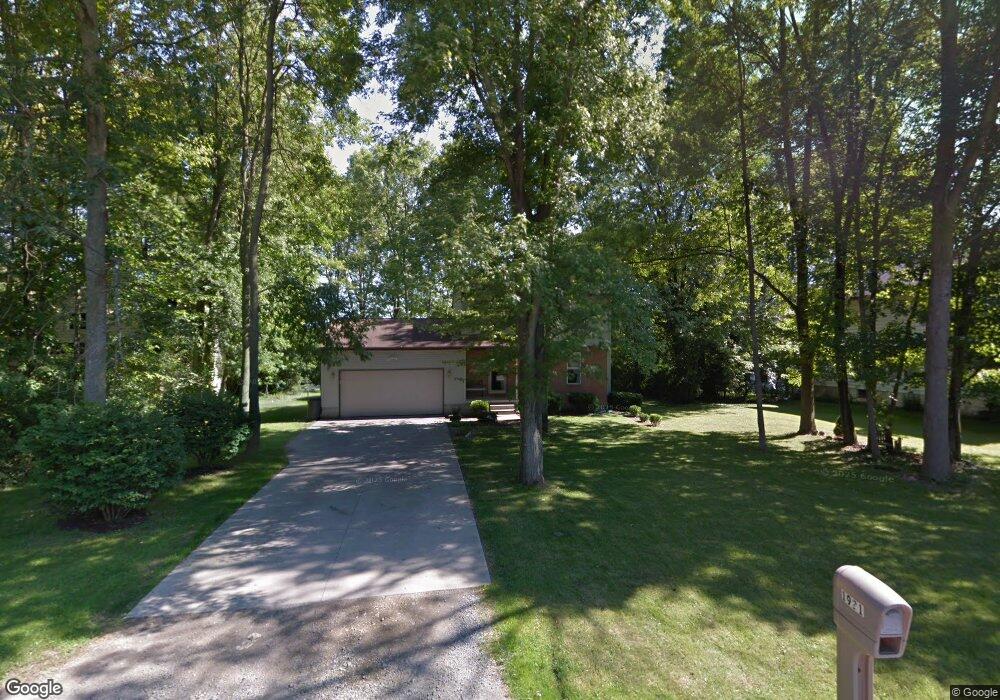
1921 Woodward Ave Youngstown, OH 44514
Estimated Value: $194,128 - $221,000
3
Beds
2
Baths
1,274
Sq Ft
$161/Sq Ft
Est. Value
About This Home
This home is located at 1921 Woodward Ave, Youngstown, OH 44514 and is currently estimated at $205,532, approximately $161 per square foot. 1921 Woodward Ave is a home located in Mahoning County with nearby schools including Poland Union Elementary School, Poland Middle School, and Poland Seminary High School.
Ownership History
Date
Name
Owned For
Owner Type
Purchase Details
Closed on
Mar 10, 2005
Sold by
Shields Adam W
Bought by
Trella Tiffaney L
Current Estimated Value
Purchase Details
Closed on
Jan 12, 1998
Sold by
Myers Richard N and Myers Lerma M
Bought by
Shields Adam W and Shields Tiffany L
Home Financials for this Owner
Home Financials are based on the most recent Mortgage that was taken out on this home.
Original Mortgage
$99,900
Interest Rate
7.26%
Purchase Details
Closed on
Feb 4, 1994
Sold by
Stauffer Mabel R
Bought by
Myers Richard N and Myers Lerma
Purchase Details
Closed on
Jan 21, 1977
Bought by
Stauffer Mabel R
Create a Home Valuation Report for This Property
The Home Valuation Report is an in-depth analysis detailing your home's value as well as a comparison with similar homes in the area
Home Values in the Area
Average Home Value in this Area
Purchase History
| Date | Buyer | Sale Price | Title Company |
|---|---|---|---|
| Trella Tiffaney L | -- | -- | |
| Shields Adam W | $110,000 | -- | |
| Myers Richard N | -- | -- | |
| Stauffer Mabel R | -- | -- |
Source: Public Records
Mortgage History
| Date | Status | Borrower | Loan Amount |
|---|---|---|---|
| Previous Owner | Shields Adam W | $99,900 |
Source: Public Records
Tax History Compared to Growth
Tax History
| Year | Tax Paid | Tax Assessment Tax Assessment Total Assessment is a certain percentage of the fair market value that is determined by local assessors to be the total taxable value of land and additions on the property. | Land | Improvement |
|---|---|---|---|---|
| 2024 | $2,365 | $46,230 | $5,430 | $40,800 |
| 2023 | $2,336 | $46,230 | $5,430 | $40,800 |
| 2022 | $2,455 | $40,510 | $5,430 | $35,080 |
| 2021 | $2,459 | $40,510 | $5,430 | $35,080 |
| 2020 | $2,469 | $40,510 | $5,430 | $35,080 |
| 2019 | $2,526 | $38,210 | $5,430 | $32,780 |
| 2018 | $2,404 | $38,210 | $5,430 | $32,780 |
| 2017 | $2,401 | $38,210 | $5,430 | $32,780 |
| 2016 | $2,444 | $37,260 | $5,430 | $31,830 |
| 2015 | $2,397 | $37,260 | $5,430 | $31,830 |
| 2014 | $2,405 | $37,260 | $5,430 | $31,830 |
| 2013 | $2,377 | $37,260 | $5,430 | $31,830 |
Source: Public Records
Map
Nearby Homes
- 1894 Lealand Ave
- 2035 Woodward Ave
- 1890 Mathews Rd
- 1859 Mathews Rd
- 1804 Alverne Dr
- 1827 Alverne Dr
- 34 Venloe Dr
- 43 Venloe Dr
- 5710 Youngstown Poland Rd
- 0 Oles Ave
- 2128 Lyon Blvd
- 2153 Lyon Blvd
- 0 Mathews Rd Unit 5149232
- 0 Mathews Rd Unit 5143059
- 0 Woodlawn Ave
- 1738 Island Dr
- 1919 Wingate Rd
- 2089 Shetland Ln
- 1841 Wingate Rd
- 2307 Hamilton Ave
- 1916 Woodward Ave
- 1947 Woodward Ave
- 1914 Woodward Ave
- 1919 Peachtree Ct
- 1923 Peachtree Ct
- 1915 Peachtree Ct
- 1927 Peachtree Ct
- 1911 Peachtree Ct
- 1931 Peachtree Ct
- 1935 Peachtree Ct
- 6052 Sheridan Rd
- 1975 Woodward Ave
- 6044 Sheridan Rd
- 1939 Peachtree Ct
- 6036 Sheridan Rd
- 6270 Sheridan Rd
- 1922 Peachtree Ct
- 1926 Peachtree Ct
- 1918 Peachtree Ct
- 6280 Sheridan Rd