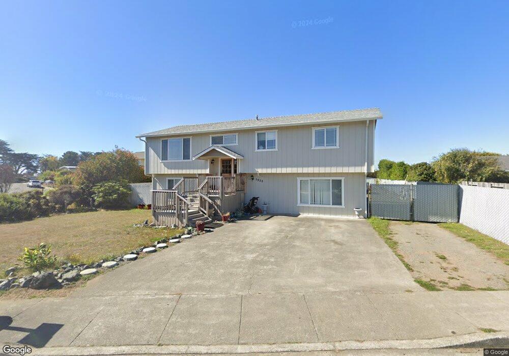
1922 Bird Ave McKinleyville, CA 95519
Estimated Value: $327,000 - $402,958
--
Bed
--
Bath
--
Sq Ft
0.35
Acres
About This Home
This home is located at 1922 Bird Ave, McKinleyville, CA 95519 and is currently estimated at $365,990. 1922 Bird Ave is a home with nearby schools including Morris Elementary School, Dow's Prairie Elementary School, and McKinleyville Middle School.
Ownership History
Date
Name
Owned For
Owner Type
Purchase Details
Closed on
Dec 27, 2021
Sold by
Henderson Sherri A
Bought by
Henderson Sherri A and Hurley Hannah Jonelle
Current Estimated Value
Home Financials for this Owner
Home Financials are based on the most recent Mortgage that was taken out on this home.
Original Mortgage
$113,000
Interest Rate
2.79%
Mortgage Type
New Conventional
Purchase Details
Closed on
Mar 25, 2008
Sold by
Depute Randy B
Bought by
Depute Sherri A
Create a Home Valuation Report for This Property
The Home Valuation Report is an in-depth analysis detailing your home's value as well as a comparison with similar homes in the area
Home Values in the Area
Average Home Value in this Area
Purchase History
| Date | Buyer | Sale Price | Title Company |
|---|---|---|---|
| Henderson Sherri A | -- | New Title Company Name | |
| Depute Sherri A | -- | None Available |
Source: Public Records
Mortgage History
| Date | Status | Borrower | Loan Amount |
|---|---|---|---|
| Previous Owner | Henderson Sherri A | $113,000 |
Source: Public Records
Tax History Compared to Growth
Tax History
| Year | Tax Paid | Tax Assessment Tax Assessment Total Assessment is a certain percentage of the fair market value that is determined by local assessors to be the total taxable value of land and additions on the property. | Land | Improvement |
|---|---|---|---|---|
| 2025 | $2,376 | $208,016 | $66,734 | $141,282 |
| 2024 | $2,376 | $203,938 | $65,426 | $138,512 |
| 2023 | $2,300 | $199,941 | $64,144 | $135,797 |
| 2022 | $2,310 | $196,022 | $62,887 | $133,135 |
| 2021 | $2,204 | $192,179 | $61,654 | $130,525 |
| 2020 | $2,117 | $190,209 | $61,022 | $129,187 |
| 2019 | $2,102 | $186,480 | $59,826 | $126,654 |
| 2018 | $2,021 | $182,824 | $58,653 | $124,171 |
| 2017 | $1,969 | $179,240 | $57,503 | $121,737 |
| 2016 | $1,933 | $175,726 | $56,376 | $119,350 |
| 2015 | -- | $173,088 | $55,530 | $117,558 |
| 2014 | $1,866 | $169,699 | $54,443 | $115,256 |
Source: Public Records
Map
Nearby Homes
- 1865 Ashdown Ave
- 2070 Thiel Ave
- 000 Anderson Ave
- 2150 Thiel Ave
- 1181 Chelsea Way
- 1472 Gavin (Lot G2) Ln
- 1658/1656 Ascent Place
- 835 Sweet Pea Ln
- 442 Mad River Rd
- 2257 Walnut Ave
- 2822 Sandpointe Dr
- 1090 Murray Rd
- 2911 Sandpointe Dr
- 2951 Sandpointe Dr
- 3002 Sandpointe Dr
- 2910 Springer Dr
- 2937 Springer Dr
- 2580 Central Ave
- 2973 Springer Dr