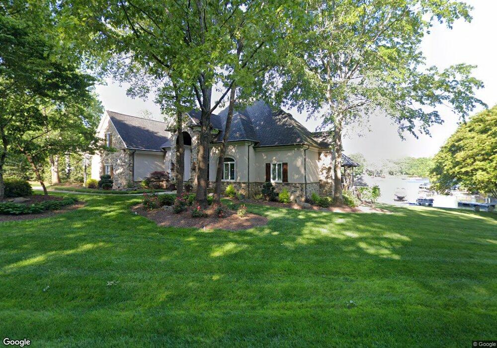
19220 Mary Ardrey Cir Cornelius, NC 28031
Estimated Value: $1,531,000 - $2,511,475
4
Beds
4
Baths
3,528
Sq Ft
$625/Sq Ft
Est. Value
About This Home
This home is located at 19220 Mary Ardrey Cir, Cornelius, NC 28031 and is currently estimated at $2,205,369, approximately $625 per square foot. 19220 Mary Ardrey Cir is a home located in Mecklenburg County with nearby schools including Cornelius Elementary School, Bailey Middle School, and William Amos Hough High School.
Ownership History
Date
Name
Owned For
Owner Type
Purchase Details
Closed on
Dec 30, 2006
Sold by
Heineman D Scott and Johnson Kurt F
Bought by
Presley Ralph L and Presley Wendy G
Current Estimated Value
Purchase Details
Closed on
Nov 19, 2004
Sold by
Presley Ralph L and Presley Wendy G
Bought by
Heineman D Scott and Johnson Kurt F
Purchase Details
Closed on
Nov 18, 1994
Sold by
Stough Farms Dev Co
Bought by
Presley Ralph L and Presley Wendy G
Create a Home Valuation Report for This Property
The Home Valuation Report is an in-depth analysis detailing your home's value as well as a comparison with similar homes in the area
Home Values in the Area
Average Home Value in this Area
Purchase History
| Date | Buyer | Sale Price | Title Company |
|---|---|---|---|
| Presley Ralph L | -- | None Available | |
| Heineman D Scott | -- | -- | |
| Presley Ralph L | $165,000 | -- |
Source: Public Records
Tax History Compared to Growth
Tax History
| Year | Tax Paid | Tax Assessment Tax Assessment Total Assessment is a certain percentage of the fair market value that is determined by local assessors to be the total taxable value of land and additions on the property. | Land | Improvement |
|---|---|---|---|---|
| 2025 | $11,583 | $1,757,600 | $920,000 | $837,600 |
| 2024 | $11,583 | $1,757,600 | $920,000 | $837,600 |
| 2023 | $8,739 | $1,757,600 | $920,000 | $837,600 |
| 2022 | $8,739 | $1,024,800 | $513,000 | $511,800 |
| 2021 | $8,637 | $1,024,800 | $513,000 | $511,800 |
| 2020 | $8,637 | $1,024,800 | $513,000 | $511,800 |
| 2019 | $8,631 | $1,024,800 | $513,000 | $511,800 |
| 2018 | $7,803 | $721,200 | $350,000 | $371,200 |
| 2017 | $7,746 | $721,200 | $350,000 | $371,200 |
| 2016 | $7,742 | $721,200 | $350,000 | $371,200 |
| 2015 | $7,631 | $721,200 | $350,000 | $371,200 |
| 2014 | $7,629 | $721,200 | $350,000 | $371,200 |
Source: Public Records
Map
Nearby Homes
- 19040 Mary Ardrey Cir
- 20400 Marblehead Ct
- 19506 Mary Ardrey Cir
- 19525 Mary Ardrey Cir
- 19112 Glouster Ct
- 19245 Stableford Ln
- 19307 Beaufain St Unit 14
- 20517 Queensdale Dr
- 17834 Jetton Green Loop Unit 20
- 20711 Bethel Church Rd
- 19241 Lake Norman Cove Dr
- 19002 Meta Rd
- 20324 Middletown Rd
- 20305 Queensdale Dr
- 20028 Northport Dr
- 19005 Northport Dr
- 19934 Walter Henderson Rd
- 20321 Bethelwood Ln
- 16116 Lakeside Loop Ln
- 20314 Colony Point Ln
- 19300 Mary Ardrey Cir
- 19118 Mary Ardrey Cir
- 19314 Mary Ardrey Cir
- 19110 Mary Ardrey Cir
- 19318 Mary Ardrey Cir
- 19326 Mary Ardrey Cir
- 19111 Mary Ardrey Cir
- 19301 Mary Ardrey Cir
- 19336 Mary Ardrey Cir
- 19012 Southport Dr
- 19022 Southport Dr
- 19027 Brandon James Dr
- 19026 Brandon James Dr
- 19327 Mary Ardrey Cir
- 19006 Southport Dr
- 19030 Mary Ardrey Cir
- 19404 Mary Ardrey Cir
- 18916 Mary Ardrey Cir
- 19028 Southport Dr
- 19000 Southport Dr