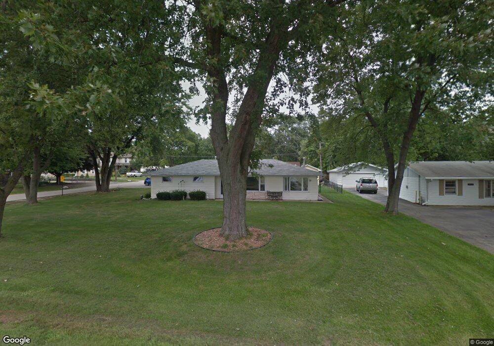
19228 Airport Rd Romeoville, IL 60446
Lewis University NeighborhoodEstimated Value: $196,735 - $283,000
--
Bed
--
Bath
1,396
Sq Ft
$172/Sq Ft
Est. Value
About This Home
This home is located at 19228 Airport Rd, Romeoville, IL 60446 and is currently estimated at $240,434, approximately $172 per square foot. 19228 Airport Rd is a home located in Will County with nearby schools including Irene King Elementary School, A. Vito Martinez Middle School, and Romeoville High School.
Ownership History
Date
Name
Owned For
Owner Type
Purchase Details
Closed on
Jul 30, 2024
Sold by
Cordova Ricardo H and Pelaes Janet
Bought by
Rdo Investments Llc - Series Airport Road
Current Estimated Value
Purchase Details
Closed on
Jun 17, 2022
Sold by
Classic Investments Llc
Bought by
Cordova Ricardo H and Pelaes Janet
Purchase Details
Closed on
Jun 9, 2022
Sold by
Corcoran Family Trust
Bought by
Kendall Partners Ltd
Purchase Details
Closed on
Jun 8, 2022
Sold by
Kendall Partners Ltd
Bought by
Classic Investments Llc
Purchase Details
Closed on
Aug 2, 2018
Sold by
Cocran Francis A and Cocran Cherie L
Bought by
Cocran Francis A and Cocran Cherie L
Purchase Details
Closed on
Jan 9, 1992
Bought by
Corcoran Francis
Create a Home Valuation Report for This Property
The Home Valuation Report is an in-depth analysis detailing your home's value as well as a comparison with similar homes in the area
Home Values in the Area
Average Home Value in this Area
Purchase History
| Date | Buyer | Sale Price | Title Company |
|---|---|---|---|
| Rdo Investments Llc - Series Airport Road | -- | None Listed On Document | |
| Cordova Ricardo H | $166,000 | None Listed On Document | |
| Kendall Partners Ltd | $132,500 | Chicago Title | |
| Classic Investments Llc | $155,000 | Castle Law | |
| Cocran Francis A | -- | Attorney | |
| Corcoran Francis | $87,000 | -- |
Source: Public Records
Tax History Compared to Growth
Tax History
| Year | Tax Paid | Tax Assessment Tax Assessment Total Assessment is a certain percentage of the fair market value that is determined by local assessors to be the total taxable value of land and additions on the property. | Land | Improvement |
|---|---|---|---|---|
| 2024 | $6,081 | $73,582 | $18,935 | $54,647 |
| 2023 | $6,081 | $66,058 | $16,999 | $49,059 |
| 2022 | $5,526 | $61,619 | $15,856 | $45,763 |
| 2021 | $5,259 | $57,907 | $14,901 | $43,006 |
| 2020 | $5,113 | $56,003 | $14,411 | $41,592 |
| 2019 | $4,836 | $53,084 | $13,660 | $39,424 |
| 2018 | $4,503 | $49,244 | $12,881 | $36,363 |
| 2017 | $4,132 | $45,576 | $11,922 | $33,654 |
| 2016 | $3,892 | $42,714 | $11,173 | $31,541 |
| 2015 | $4,151 | $40,641 | $10,631 | $30,010 |
| 2014 | $4,151 | $39,457 | $10,321 | $29,136 |
| 2013 | $4,151 | $44,837 | $11,728 | $33,109 |
Source: Public Records
Map
Nearby Homes
- 15035 Hartman Dr
- 1.4 Acres S Archer Ave
- 1600 Fairmount
- Lot 24 W Windemere Cir
- Lot 13 W Windemere Cir
- 17439 W Windemere Cir
- 17529 W Windemere Cir
- 242 Tallman Ave
- 204 Healy Ave
- 221 Murphy Dr
- 408 Haller Ave
- 729 Vine St
- 4 Larsen Cir
- 923 E Savannah Dr Unit 2
- Lot 2 Governors Hwy
- 0 N Weber Rd Unit MRD12364369
- 939 E Savannah Dr
- 312 Fremont Ave
- 120 N State St
- 118 N State St
- 19220 Airport Rd
- 19220 Airport Rd
- 19227 Jacquie Ave
- 19240 Airport Rd
- 19217 Jacquie Ave
- 19212 Airport Rd
- 19213 Jacquie Ave
- 15046 Lewis Dr
- 15046 Lewis Dr
- 19248 Airport Rd
- 19202 Airport Rd
- 15036 Lewis Dr
- 19205 Jacquie Ave
- 19256 Airport Rd
- 19256 Airport Rd
- 19160 Airport Rd Unit 1
- 19256 W Airport Rd
- 19226 Jacquie Ave
- 15026 Lewis Dr
- 19218 Jacquie Ave