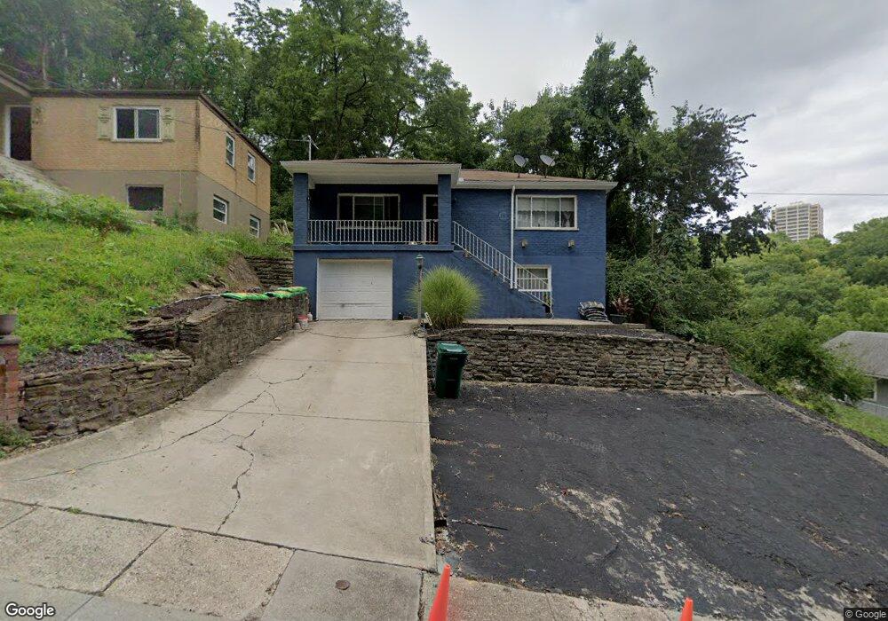
1924 Brinkmeier Ave Cincinnati, OH 45225
North Fairmount NeighborhoodEstimated Value: $96,000 - $200,000
4
Beds
2
Baths
900
Sq Ft
$150/Sq Ft
Est. Value
About This Home
This home is located at 1924 Brinkmeier Ave, Cincinnati, OH 45225 and is currently estimated at $135,351, approximately $150 per square foot. 1924 Brinkmeier Ave is a home located in Hamilton County with nearby schools including Robert A. Taft Information Technology High School, Western Hills High School, and Gilbert A. Dater High School.
Ownership History
Date
Name
Owned For
Owner Type
Purchase Details
Closed on
Mar 15, 2001
Sold by
Odell Robinson
Bought by
Robinson Daryl
Current Estimated Value
Home Financials for this Owner
Home Financials are based on the most recent Mortgage that was taken out on this home.
Original Mortgage
$52,500
Interest Rate
7.05%
Create a Home Valuation Report for This Property
The Home Valuation Report is an in-depth analysis detailing your home's value as well as a comparison with similar homes in the area
Home Values in the Area
Average Home Value in this Area
Purchase History
| Date | Buyer | Sale Price | Title Company |
|---|---|---|---|
| Robinson Daryl | $48,000 | -- |
Source: Public Records
Mortgage History
| Date | Status | Borrower | Loan Amount |
|---|---|---|---|
| Closed | Robinson Daryl | $52,500 |
Source: Public Records
Tax History Compared to Growth
Tax History
| Year | Tax Paid | Tax Assessment Tax Assessment Total Assessment is a certain percentage of the fair market value that is determined by local assessors to be the total taxable value of land and additions on the property. | Land | Improvement |
|---|---|---|---|---|
| 2024 | $1,535 | $25,495 | $5,653 | $19,842 |
| 2023 | $1,569 | $25,495 | $5,653 | $19,842 |
| 2022 | $960 | $13,896 | $4,939 | $8,957 |
| 2021 | $920 | $13,896 | $4,939 | $8,957 |
| 2020 | $947 | $13,896 | $4,939 | $8,957 |
| 2019 | $940 | $12,632 | $4,491 | $8,141 |
| 2018 | $942 | $12,632 | $4,491 | $8,141 |
| 2017 | $894 | $12,632 | $4,491 | $8,141 |
| 2016 | $1,262 | $17,627 | $5,737 | $11,890 |
| 2015 | $1,138 | $17,627 | $5,737 | $11,890 |
| 2014 | $1,146 | $17,627 | $5,737 | $11,890 |
| 2013 | $1,266 | $19,156 | $6,234 | $12,922 |
Source: Public Records
Map
Nearby Homes
- 1965 Baltimore Ave
- 1854 Carll St
- 1859 Baltimore Ave
- 2085 N Teralta Cir
- 1808 Carll St
- 2114 Saint Leo Place
- 1797 Denham St
- 2009 Harrison Ave
- 2082 Harrison Ave
- 2063 Harrison Ave
- 2117 Saint Leo Place
- 1977 Harrison Ave
- 2060 Bickel Ave
- 1770 Carll St
- 3407 Ninann Ct
- 1756 Carll St
- 2711 Baker Ave
- 2828 Ruberg Ave
- 3384 Ninann Ct
- 1721 Sutter Ave
- 1928 Brinkmeier Ave
- 1916 Brinkmeier Ave
- 1912 Brinkmeier Ave
- 1921 Brinkmeier Ave
- 1917 Brinkmeier Ave
- 1969 Baltimore Ave
- 1915 Brinkmeier Ave
- 1967 Baltimore Ave
- 1963 Baltimore Ave
- 1961 Baltimore Ave
- 1957 Baltimore Ave
- 1982 Baltimore Ave
- 1984 Baltimore Ave
- 1980 Baltimore Ave
- 1978 Baltimore Ave
- 1986 Baltimore Ave
- 1972 Baltimore Ave
- 1988 Baltimore Ave
- 1970 Baltimore Ave
- 1990 Baltimore Ave