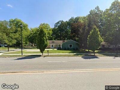
1924 Maplecrest Rd Fort Wayne, IN 46815
Valley Park Forest NeighborhoodEstimated Value: $237,000 - $245,000
3
Beds
3
Baths
1,950
Sq Ft
$124/Sq Ft
Est. Value
About This Home
This home is located at 1924 Maplecrest Rd, Fort Wayne, IN 46815 and is currently estimated at $241,058, approximately $123 per square foot. 1924 Maplecrest Rd is a home located in Allen County with nearby schools including J Wilbur Haley Elementary School, Blackhawk Middle School, and R Nelson Snider High School.
Ownership History
Date
Name
Owned For
Owner Type
Purchase Details
Closed on
Aug 12, 2013
Sold by
Harley Kenneth M and Harley Marlo
Bought by
City Of Fort Wayne
Current Estimated Value
Purchase Details
Closed on
Jul 16, 2013
Sold by
Harley Kenneth M and Harley Marlo
Bought by
City Of Fort Wayne Indiana
Purchase Details
Closed on
Jan 30, 2009
Sold by
Harley Kenneth M
Bought by
Harley Kenneth M and Harley Marlo
Home Financials for this Owner
Home Financials are based on the most recent Mortgage that was taken out on this home.
Original Mortgage
$97,754
Interest Rate
5.08%
Mortgage Type
FHA
Purchase Details
Closed on
Mar 13, 2003
Sold by
Knoblauch Dennis J and Knoblauch Barbara J
Bought by
Knoblauch Barbara J and The Barbara J Knoblauch Trust
Create a Home Valuation Report for This Property
The Home Valuation Report is an in-depth analysis detailing your home's value as well as a comparison with similar homes in the area
Home Values in the Area
Average Home Value in this Area
Purchase History
| Date | Buyer | Sale Price | Title Company |
|---|---|---|---|
| City Of Fort Wayne Indiana | $4,320 | None Available | |
| Harley Kenneth M | -- | Metropolitan Title Of In | |
| Harley Kenneth M | -- | Metropolitan Title Of In | |
| Knoblauch Barbara J | -- | Commonwealth Land Title Co |
Source: Public Records
Mortgage History
| Date | Status | Borrower | Loan Amount |
|---|---|---|---|
| Open | Harley Len | $45,000 | |
| Previous Owner | Harley Kenneth M | $97,754 |
Source: Public Records
Tax History Compared to Growth
Tax History
| Year | Tax Paid | Tax Assessment Tax Assessment Total Assessment is a certain percentage of the fair market value that is determined by local assessors to be the total taxable value of land and additions on the property. | Land | Improvement |
|---|---|---|---|---|
| 2024 | $1,841 | $198,600 | $28,000 | $170,600 |
| 2023 | $1,841 | $174,000 | $28,000 | $146,000 |
| 2022 | $1,546 | $139,400 | $28,000 | $111,400 |
| 2021 | $1,391 | $126,400 | $24,700 | $101,700 |
| 2020 | $1,459 | $134,900 | $24,700 | $110,200 |
| 2019 | $1,345 | $125,200 | $24,700 | $100,500 |
| 2018 | $1,279 | $118,700 | $24,700 | $94,000 |
| 2017 | $1,160 | $107,400 | $24,700 | $82,700 |
| 2016 | $1,119 | $104,900 | $24,700 | $80,200 |
| 2014 | $1,063 | $103,500 | $24,700 | $78,800 |
| 2013 | $1,002 | $98,100 | $25,000 | $73,100 |
Source: Public Records
Map
Nearby Homes
- 6120 Cordava Ct
- 6511 Dumont Dr
- 2005 Forest Valley Dr
- 5912 Monarch Dr
- 2801 Old Willow Place
- 1612 Randford Place
- 6932 White Eagle Dr
- 1304 Ardsley Ct
- 2522 Kingston Point
- 1914 Bear Paw Dr
- 1502 Lofton Way
- 2620 Knightsbridge Dr
- 1816 Montgomery Ct
- 6611 Trickingham Ct
- 2704 Busche Dr
- 3026 Seafarer Cove
- 7230 White Eagle Dr
- 2215 Cimarron Pass
- 7286 Starks (Lot 11) Blvd
- 7342 Starks (Lot 8) Blvd
- 1924 Maplecrest Rd
- 1916 Maplecrest Rd
- 6334 Bennington Dr
- 6321 Bennington Dr
- 1908 Maplecrest Rd
- 6331 Bennington Dr
- 6333 Monarch Dr
- 6408 Bennington Dr
- 6231 Monarch Dr
- 6405 Bennington Dr
- 6407 Monarch Dr
- 6418 Bennington Dr
- 6223 Monarch Dr
- 6411 Bennington Dr
- 6324 Monarch Dr
- 6417 Monarch Dr
- 6334 Monarch Dr
- 6215 Monarch Dr
- 6428 Bennington Dr
- 6236 Monarch Dr