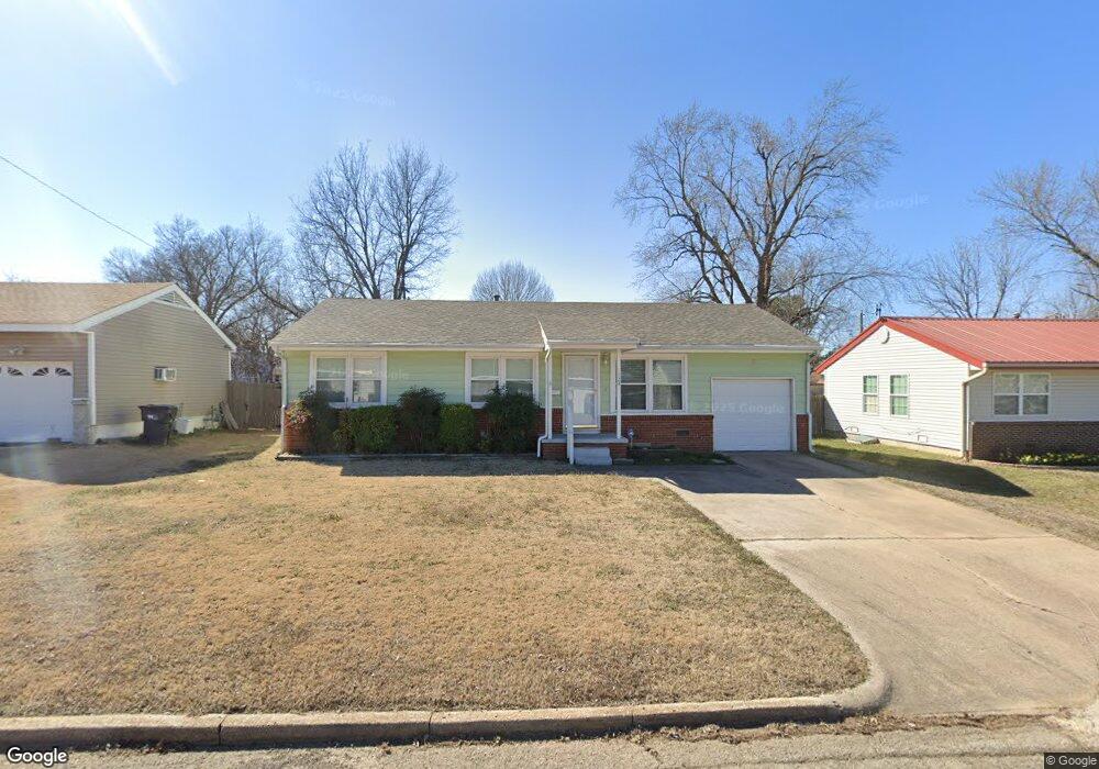
1924 S Scott St Sapulpa, OK 74066
Estimated Value: $100,240 - $146,000
2
Beds
1
Bath
912
Sq Ft
$135/Sq Ft
Est. Value
About This Home
This home is located at 1924 S Scott St, Sapulpa, OK 74066 and is currently estimated at $123,560, approximately $135 per square foot. 1924 S Scott St is a home located in Creek County with nearby schools including Sapulpa Middle School, Sapulpa Junior High School, and Sapulpa High School.
Ownership History
Date
Name
Owned For
Owner Type
Purchase Details
Closed on
May 31, 2005
Sold by
Oliveros Amanda G
Bought by
Mccrory John Brandon
Current Estimated Value
Home Financials for this Owner
Home Financials are based on the most recent Mortgage that was taken out on this home.
Original Mortgage
$62,000
Outstanding Balance
$32,306
Interest Rate
5.83%
Mortgage Type
New Conventional
Estimated Equity
$91,254
Create a Home Valuation Report for This Property
The Home Valuation Report is an in-depth analysis detailing your home's value as well as a comparison with similar homes in the area
Home Values in the Area
Average Home Value in this Area
Purchase History
| Date | Buyer | Sale Price | Title Company |
|---|---|---|---|
| Mccrory John Brandon | $69,000 | Frisco Title Corporation |
Source: Public Records
Mortgage History
| Date | Status | Borrower | Loan Amount |
|---|---|---|---|
| Open | Mccrory John Brandon | $62,000 |
Source: Public Records
Tax History Compared to Growth
Tax History
| Year | Tax Paid | Tax Assessment Tax Assessment Total Assessment is a certain percentage of the fair market value that is determined by local assessors to be the total taxable value of land and additions on the property. | Land | Improvement |
|---|---|---|---|---|
| 2025 | $510 | $5,351 | $1,854 | $3,497 |
| 2024 | $510 | $5,195 | $1,800 | $3,395 |
| 2023 | $510 | $5,044 | $1,800 | $3,244 |
| 2022 | $448 | $4,897 | $1,800 | $3,097 |
| 2021 | $1,002 | $9,444 | $1,800 | $7,644 |
| 2020 | $964 | $9,168 | $1,800 | $7,368 |
| 2019 | $937 | $8,901 | $1,800 | $7,101 |
| 2018 | $925 | $8,642 | $1,800 | $6,842 |
| 2017 | $920 | $8,642 | $1,800 | $6,842 |
| 2016 | $875 | $8,642 | $1,800 | $6,842 |
| 2015 | -- | $8,642 | $1,800 | $6,842 |
| 2014 | -- | $8,574 | $1,620 | $6,954 |
Source: Public Records
Map
Nearby Homes
- 1965 S Scott St
- 1836 S Oklahoma St
- 605 W Mockingbird Ln
- 1915 S Muskogee St
- 1424 S Main St
- 119 E Ross Ave
- 142 W Fairlane Ct
- 1220 S Cedar St
- 41 W Fairlane Ct
- 120 E Burnham Ave
- 273 W Fairlane Dr
- 19 E Fairlane Ct
- 416 W Fairlane Dr Unit A-B
- 211 E Wells Blvd
- 119 E Davis Ave
- 121 E Davis Ave
- 925 S Oklahoma St
- 103 E Fairlane Ct
- 910 S Diane St
- 920 S Oklahoma St
- 1916 S Scott St
- 1916 S Scott St
- 1932 S Scott St
- 1925 S Independence St
- 1908 S Scott St
- 1933 S Independence St
- 1917 S Independence St
- 1925 S Scott St
- 1909 S Independence St
- 1941 S Independence St
- 1917 S Scott St
- 1948 S Scott St
- 1900 S Scott St
- 1909 S Scott St
- 1941 S Scott St
- 1949 S Independence St
- 1901 S Independence St
- 1956 S Scott St
- 1949 S Scott St