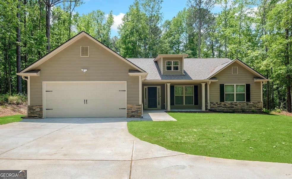

1925 Millard Farmer Rd Newnan, GA 30263
Estimated payment $2,583/month
Highlights
- Craftsman Architecture
- Private Lot
- Solid Surface Countertops
- Wood Burning Stove
- Vaulted Ceiling
- No HOA
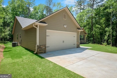
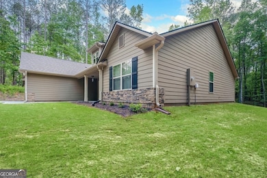
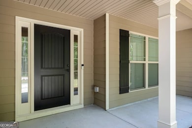
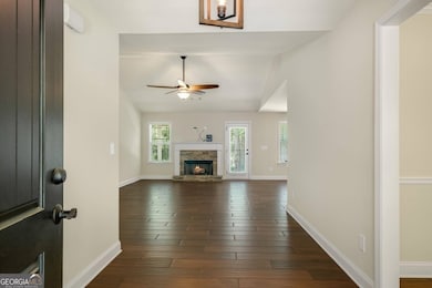
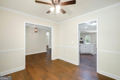
About This Home
This inviting step-less 4-bedroom, 2-bath ranch is nestled on a private, wooded 2-acre lot. Inside, you'll find a lovely great room with a wood burning fireplace, and a split bedroom plan. The oversized master features vaulted ceilings, and an en-suite with a spacious tile shower, a separate garden tub, large closet, and double vanities. The kitchen offers stainless steel appliances, granite countertops, and a large breakfast area with dining bar. Elegant tile flooring runs throughout the home. Above the garage, the floored space provides plenty of additional storage. The property sits 500 feet off the road for exceptional privacy, and the backyard includes a large area with chain-link fencing-perfect for pets or outdoor activities.
Home Details
Home Type
- Single Family
Est. Annual Taxes
- $3,317
Year Built
- Built in 2021
Lot Details
- 2.05 Acre Lot
- Back Yard Fenced
- Chain Link Fence
- Private Lot
Home Design
- Craftsman Architecture
- Slab Foundation
- Composition Roof
- Concrete Siding
- Stone Siding
- Stone
Interior Spaces
- 1,963 Sq Ft Home
- 1-Story Property
- Vaulted Ceiling
- Ceiling Fan
- Wood Burning Stove
- Living Room with Fireplace
- Home Office
- Tile Flooring
- Pull Down Stairs to Attic
Kitchen
- Breakfast Area or Nook
- Breakfast Bar
- Oven or Range
- Microwave
- Ice Maker
- Dishwasher
- Stainless Steel Appliances
- Solid Surface Countertops
Bedrooms and Bathrooms
- 4 Main Level Bedrooms
- Split Bedroom Floorplan
- Walk-In Closet
- 2 Full Bathrooms
- Double Vanity
- Soaking Tub
- Bathtub Includes Tile Surround
- Separate Shower
Laundry
- Laundry in Mud Room
- Dryer
- Washer
Parking
- Garage
- Garage Door Opener
Schools
- Atkinson Elementary School
- Smokey Road Middle School
- Newnan High School
Utilities
- Central Heating and Cooling System
- Electric Water Heater
- Septic Tank
- High Speed Internet
- Phone Available
- Cable TV Available
Community Details
- No Home Owners Association
- Newnan Farms Subdivision
Map
Home Values in the Area
Average Home Value in this Area
Tax History
| Year | Tax Paid | Tax Assessment Tax Assessment Total Assessment is a certain percentage of the fair market value that is determined by local assessors to be the total taxable value of land and additions on the property. | Land | Improvement |
|---|---|---|---|---|
| 2025 | $3,324 | $146,950 | $13,789 | $133,161 |
| 2024 | $3,213 | $143,014 | $13,789 | $129,225 |
| 2023 | $3,213 | $139,187 | $18,976 | $120,212 |
| 2022 | $2,677 | $108,652 | $12,650 | $96,002 |
| 2021 | $2,413 | $91,664 | $12,048 | $79,616 |
| 2020 | $494 | $18,649 | $18,649 | $0 |
| 2019 | $404 | $13,812 | $13,812 | $0 |
| 2018 | $405 | $13,812 | $13,812 | $0 |
| 2017 | $405 | $13,812 | $13,812 | $0 |
| 2016 | $400 | $13,812 | $13,812 | $0 |
| 2015 | $393 | $13,812 | $13,812 | $0 |
| 2014 | -- | $13,812 | $13,812 | $0 |
Property History
| Date | Event | Price | List to Sale | Price per Sq Ft |
|---|---|---|---|---|
| 12/01/2025 12/01/25 | For Sale | $439,900 | -- | $224 / Sq Ft |
Purchase History
| Date | Type | Sale Price | Title Company |
|---|---|---|---|
| Warranty Deed | $400,000 | -- | |
| Warranty Deed | $299,900 | -- | |
| Warranty Deed | $341,000 | -- | |
| Deed | -- | -- |
Mortgage History
| Date | Status | Loan Amount | Loan Type |
|---|---|---|---|
| Previous Owner | $239,920 | New Conventional |
Source: Georgia MLS
MLS Number: 10651507
APN: 076-2055-016
Disclaimer: Certain information contained herein is derived from information provided by parties other than Homes.com. All information provided is deemed reliable, but is not guaranteed to be accurate and should be independently verified.
![]() The data relating to real estate for sale on this web site comes in part from the Broker Reciprocity Program of Georgia MLS. Real estate listings held by brokerage firms other than Redfin are marked with the Broker Reciprocity logo and detailed information about them includes the name of the listing brokers. Information deemed reliable but not guaranteed. Copyright 2025 Georgia MLS. All rights reserved.
The data relating to real estate for sale on this web site comes in part from the Broker Reciprocity Program of Georgia MLS. Real estate listings held by brokerage firms other than Redfin are marked with the Broker Reciprocity logo and detailed information about them includes the name of the listing brokers. Information deemed reliable but not guaranteed. Copyright 2025 Georgia MLS. All rights reserved.
- 46 Brandish Dr
- 23 Corn Crib Dr
- 146 Moody Farm Rd
- 23 Corn Crib Ct
- 325 Brandish Dr
- 150 Cresswind Blvd
- 55 Milestone Trace
- 185 Widgeon Dr
- Whitney Plan at Cresswind at Spring Haven - Monroe Collection
- Taylor Plan at Cresswind at Spring Haven - Monroe Collection
- Emily Plan at Cresswind at Spring Haven - Carson Collection
- Madison Plan at Cresswind at Spring Haven - Carson Collection
- Valerie Plan at Cresswind at Spring Haven - Monroe Collection
- Riley Plan at Cresswind at Spring Haven - Hepburn Collection
- Lila Plan at Cresswind at Spring Haven - Carson Collection
- Sydney Plan at Cresswind at Spring Haven - Hepburn Collection
- Beverly Plan at Cresswind at Spring Haven - Bacal Collection
- Julia Plan at Cresswind at Spring Haven - Carson Collection
- Caroline Plan at Cresswind at Spring Haven - Bacal Collection
- Paige Plan at Cresswind at Spring Haven - Hepburn Collection
- 492 Pine Rd
- 35 Club Cresswind
- 9 Meridian Dr
- 50 Beverly Park Ct
- 242 Lagrange St
- 425 Smokey Rd
- 100 Fairview Dr
- 203 Preserve Dr
- 22 E Newnan Rd
- 59 Tahoe Dr
- 18 E Newnan Rd
- 105 Sunrise Dr
- 15 Cityview Dr
- 3 Rockcress Ct
- 138 Greison Trail
- 49 Preserve Dr
- 13 Greenville St S Unit B
- 13 Greenville St S Unit A
- 25 Preserve Dr
- 15 Club Cresswind Dr
