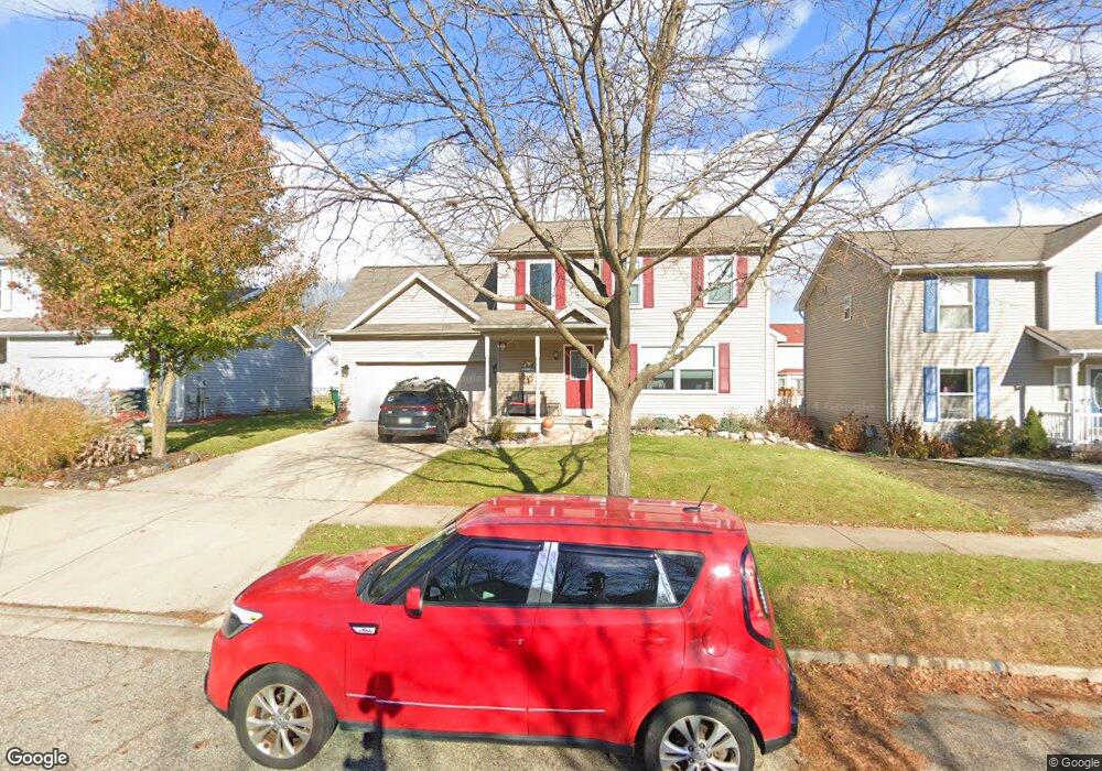
1925 Remsing Dr Lansing, MI 48911
Southern Lansing NeighborhoodEstimated Value: $267,000 - $303,524
3
Beds
3
Baths
1,488
Sq Ft
$190/Sq Ft
Est. Value
About This Home
This home is located at 1925 Remsing Dr, Lansing, MI 48911 and is currently estimated at $283,131, approximately $190 per square foot. 1925 Remsing Dr is a home located in Ingham County with nearby schools including Elliott Elementary School, Hope Middle School, and Holt Junior High School.
Ownership History
Date
Name
Owned For
Owner Type
Purchase Details
Closed on
Dec 8, 2004
Sold by
Holley Joseph N and Holley Lynn A
Bought by
Taylor Patrick and Taylor Nichole
Current Estimated Value
Home Financials for this Owner
Home Financials are based on the most recent Mortgage that was taken out on this home.
Original Mortgage
$150,000
Outstanding Balance
$75,370
Interest Rate
5.78%
Mortgage Type
Purchase Money Mortgage
Estimated Equity
$207,761
Purchase Details
Closed on
Dec 17, 2003
Sold by
Remsing Richard W and Remsing Seka Loree
Bought by
Holley Joseph N and Holley Lynn A
Home Financials for this Owner
Home Financials are based on the most recent Mortgage that was taken out on this home.
Original Mortgage
$138,400
Interest Rate
4.62%
Mortgage Type
Purchase Money Mortgage
Create a Home Valuation Report for This Property
The Home Valuation Report is an in-depth analysis detailing your home's value as well as a comparison with similar homes in the area
Home Values in the Area
Average Home Value in this Area
Purchase History
| Date | Buyer | Sale Price | Title Company |
|---|---|---|---|
| Taylor Patrick | $187,500 | Mid | |
| Holley Joseph N | $34,900 | Midstate Title Co |
Source: Public Records
Mortgage History
| Date | Status | Borrower | Loan Amount |
|---|---|---|---|
| Open | Taylor Patrick | $150,000 | |
| Previous Owner | Holley Joseph N | $138,400 | |
| Closed | Taylor Patrick | $28,125 |
Source: Public Records
Tax History
| Year | Tax Paid | Tax Assessment Tax Assessment Total Assessment is a certain percentage of the fair market value that is determined by local assessors to be the total taxable value of land and additions on the property. | Land | Improvement |
|---|---|---|---|---|
| 2025 | $4,688 | $140,200 | $13,000 | $127,200 |
| 2024 | $28 | $123,100 | $13,000 | $110,100 |
| 2023 | $4,365 | $109,200 | $13,000 | $96,200 |
| 2022 | $3,939 | $100,800 | $10,900 | $89,900 |
| 2021 | $3,874 | $94,600 | $10,900 | $83,700 |
| 2020 | $3,906 | $99,900 | $10,900 | $89,000 |
| 2019 | $3,729 | $89,900 | $10,900 | $79,000 |
| 2018 | $3,694 | $75,300 | $10,900 | $64,400 |
| 2017 | $3,542 | $75,300 | $10,900 | $64,400 |
| 2016 | $3,439 | $64,600 | $10,900 | $53,700 |
| 2015 | $3,439 | $57,700 | $21,707 | $35,993 |
| 2014 | $3,439 | $54,500 | $19,681 | $34,819 |
Source: Public Records
Map
Nearby Homes
- 4485 Helmsway Dr
- 6815 Aurelius Rd
- 2702 Yachtsman Dr
- 2670 Brigantine Dr
- 7011 Aurelius Rd
- 2541 Selma St
- 1521 Born Trail Unit lot 232
- 4345 Keelson Dr
- 7061 W Bickett Blvd
- 4348 Norway St
- 1743 Maisonette Dr
- 2564 Winterberry St
- 6309 Beechfield Dr Unit 45
- 6354 Beechfield Dr Unit 64
- 2545 Limerick Cir Unit 8
- 1265 Roth Dr
- 6300 Beechfield Dr Unit 87
- 6264 Beechfield Dr Unit 97
- 6223 Beechfield Dr Unit 8
- 6115 Lerner Way
- 1919 Remsing Dr
- 1931 Remsing Dr
- 1924 Bowker Dr
- 1930 Bowker Dr
- 1913 Remsing Dr
- 1937 Remsing Dr
- 1918 Bowker Dr
- 1936 Bowker Dr
- 1924 Remsing Dr
- 1912 Bowker Dr
- 1918 Remsing Dr
- 1930 Remsing Dr
- 1907 Remsing Dr
- 1941 Remsing Dr
- 1912 Remsing Dr
- 1936 Remsing Dr
- 1942 Bowker Dr
- 1906 Bowker Dr
- 1906 Remsing Dr
- 1942 Remsing Dr