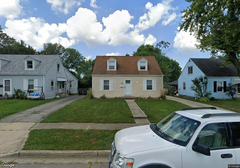
1927 Farmside Dr Dayton, OH 45420
Estimated Value: $175,000 - $182,842
3
Beds
1
Bath
1,008
Sq Ft
$179/Sq Ft
Est. Value
About This Home
This home is located at 1927 Farmside Dr, Dayton, OH 45420 and is currently estimated at $179,961, approximately $178 per square foot. 1927 Farmside Dr is a home located in Montgomery County with nearby schools including Greenmont Elementary School, Kettering Middle School, and Kettering Fairmont High School.
Ownership History
Date
Name
Owned For
Owner Type
Purchase Details
Closed on
Mar 30, 1998
Sold by
Colvin Catherine R and Colvin Catherine R
Bought by
Mcclintock Thomas D and Mcclintock Catherine R
Current Estimated Value
Home Financials for this Owner
Home Financials are based on the most recent Mortgage that was taken out on this home.
Original Mortgage
$48,000
Outstanding Balance
$9,184
Interest Rate
7.19%
Estimated Equity
$170,777
Purchase Details
Closed on
Oct 26, 1993
Sold by
Colvin Robert D
Bought by
Colvin Catherine R
Create a Home Valuation Report for This Property
The Home Valuation Report is an in-depth analysis detailing your home's value as well as a comparison with similar homes in the area
Home Values in the Area
Average Home Value in this Area
Purchase History
| Date | Buyer | Sale Price | Title Company |
|---|---|---|---|
| Mcclintock Thomas D | -- | -- | |
| Mcclintock Thomas D | -- | -- | |
| Colvin Catherine R | -- | Midwest Abstract Co |
Source: Public Records
Mortgage History
| Date | Status | Borrower | Loan Amount |
|---|---|---|---|
| Open | Mcclintock Thomas D | $48,000 |
Source: Public Records
Tax History Compared to Growth
Tax History
| Year | Tax Paid | Tax Assessment Tax Assessment Total Assessment is a certain percentage of the fair market value that is determined by local assessors to be the total taxable value of land and additions on the property. | Land | Improvement |
|---|---|---|---|---|
| 2024 | $3,099 | $49,460 | $11,010 | $38,450 |
| 2023 | $3,099 | $49,460 | $11,010 | $38,450 |
| 2022 | $2,742 | $34,530 | $7,700 | $26,830 |
| 2021 | $2,539 | $34,530 | $7,700 | $26,830 |
| 2020 | $2,546 | $34,530 | $7,700 | $26,830 |
| 2019 | $2,522 | $30,240 | $7,700 | $22,540 |
| 2018 | $2,536 | $30,240 | $7,700 | $22,540 |
| 2017 | $2,338 | $30,240 | $7,700 | $22,540 |
| 2016 | $2,185 | $26,520 | $7,700 | $18,820 |
| 2015 | $2,162 | $26,520 | $7,700 | $18,820 |
| 2014 | $2,162 | $26,520 | $7,700 | $18,820 |
| 2012 | -- | $29,740 | $8,400 | $21,340 |
Source: Public Records
Map
Nearby Homes
- 1910 Roop Place
- 1914 W Bataan Dr
- 2139 E Bataan Dr
- 1744 Woodman Dr
- 1512 Horlacher Ave
- 1513 Horlacher Ave
- 2530 Barryknoll St
- 1840 Culver Ave
- 2830 Kennedy Ave
- 4802 Amesborough Rd
- 5369 Haverfield Rd
- 4643 Amesborough Rd
- 1619 Townsley Rd
- 2004 Hazel Ave
- 1701 Marilyn Ave
- 2603 Kennedy Ave
- 1829 Hazel Ave
- 4549 Amesborough Rd
- 1300 Watervliet Ave
- 2704 Hazel Ave
- 1923 Farmside Dr
- 1931 Farmside Dr
- 1919 Farmside Dr
- 1935 Farmside Dr
- 1903 Roop Place
- 1944 E Bataan Dr
- 1915 Farmside Dr
- 1939 Farmside Dr
- 1940 E Bataan Dr
- 1948 E Bataan Dr
- 1954 E Bataan Dr
- 1936 E Bataan Dr
- 1926 Farmside Dr
- 1909 Farmside Dr
- 1905 Roop Place
- 1922 Farmside Dr
- 1930 Farmside Dr
- 1918 Farmside Dr
- 1945 Farmside Dr
- 1934 Farmside Dr