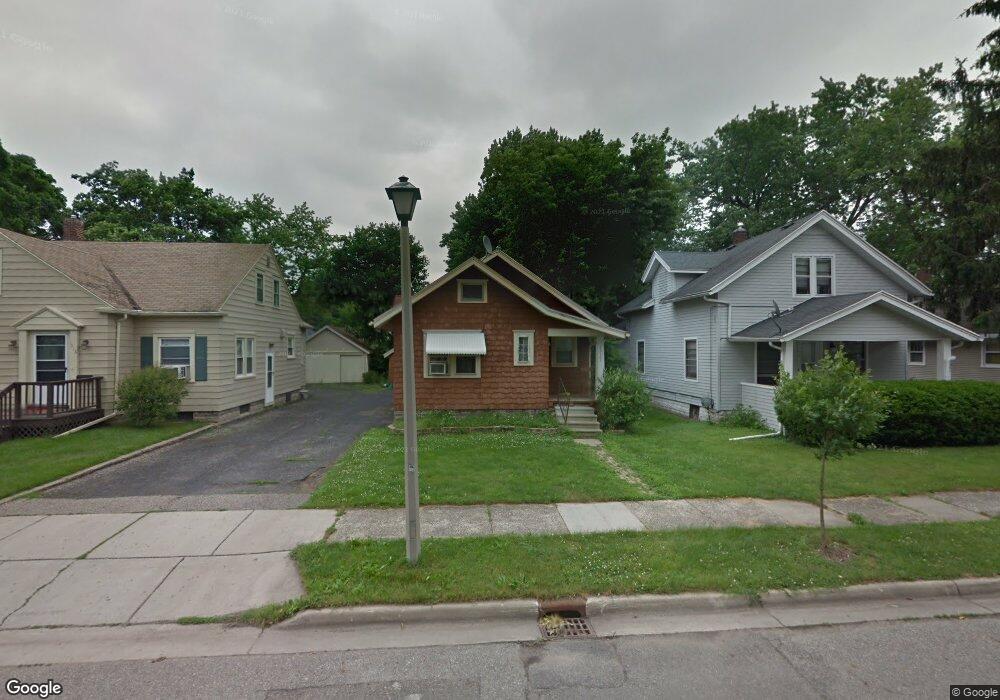
1927 Harding Ave Lansing, MI 48910
Clifford Park NeighborhoodEstimated Value: $118,000 - $142,000
Studio
--
Bath
796
Sq Ft
$158/Sq Ft
Est. Value
About This Home
This home is located at 1927 Harding Ave, Lansing, MI 48910 and is currently estimated at $125,958, approximately $158 per square foot. 1927 Harding Ave is a home located in Ingham County with nearby schools including Lyons Elementary School, Pattengill Academy, and Eastern High School.
Ownership History
Date
Name
Owned For
Owner Type
Purchase Details
Closed on
Dec 23, 2016
Sold by
Kenyon Eugene M
Bought by
Kenyon Robin L
Current Estimated Value
Purchase Details
Closed on
Sep 26, 2002
Sold by
Apostol Patrice
Bought by
Kenyon Eugene M
Purchase Details
Closed on
Mar 31, 1998
Sold by
Vanvalkenburg Jefti L
Bought by
Apostol Patrice
Create a Home Valuation Report for This Property
The Home Valuation Report is an in-depth analysis detailing your home's value as well as a comparison with similar homes in the area
Home Values in the Area
Average Home Value in this Area
Purchase History
| Date | Buyer | Sale Price | Title Company |
|---|---|---|---|
| Kenyon Robin L | $82,500 | None Available | |
| Kenyon Eugene M | $82,500 | -- | |
| Apostol Patrice | -- | -- | |
| Apostol Patrice | $43,000 | -- |
Source: Public Records
Tax History
| Year | Tax Paid | Tax Assessment Tax Assessment Total Assessment is a certain percentage of the fair market value that is determined by local assessors to be the total taxable value of land and additions on the property. | Land | Improvement |
|---|---|---|---|---|
| 2025 | $3,101 | $56,600 | $8,100 | $48,500 |
| 2024 | $26 | $48,600 | $8,100 | $40,500 |
| 2023 | $2,300 | $45,200 | $8,100 | $37,100 |
| 2022 | $2,076 | $39,700 | $7,600 | $32,100 |
| 2021 | $2,033 | $37,100 | $6,500 | $30,600 |
| 2020 | $2,020 | $36,400 | $6,500 | $29,900 |
| 2019 | $1,935 | $34,100 | $6,500 | $27,600 |
| 2018 | $1,815 | $32,000 | $6,500 | $25,500 |
| 2017 | $1,737 | $32,000 | $6,500 | $25,500 |
| 2016 | $1,661 | $31,100 | $6,500 | $24,600 |
| 2015 | $1,661 | $29,900 | $13,061 | $16,839 |
| 2014 | $1,661 | $29,100 | $16,180 | $12,920 |
Source: Public Records
Map
Nearby Homes
- 1406 E Mount Hope Ave
- 2215 Alpha St
- 2201 S Pennsylvania Ave
- 0 E Mount Hope Ave
- 2237 Sunnyside Ave
- 2309 S Pennsylvania Ave
- 1501 Shubel Ave
- 1731 Lyons Ave
- 1701 Lyons Ave
- 704 Mckim Ave
- 1423 Pontiac St
- 1437 Ada St
- 1601 Bailey St
- 2118 Roberts Ln
- 1522 Bailey St
- 1535 Linval St
- 1515 Linval St
- 534 Isbell St
- 706 Beulah St
- 555 Tisdale Ave
- 1923 Harding Ave
- 1931 Harding Ave
- 1919 Harding Ave
- 1933 Harding Ave
- 1926 Clifton Ave
- 1915 Harding Ave
- 1930 Clifton Ave
- 1922 Clifton Ave
- 1918 Clifton Ave
- 1932 Clifton Ave
- 1913 Harding Ave
- 1916 Clifton Ave
- 1926 Harding Ave
- 1930 Harding Ave
- 1304 Elmore St
- 1920 Harding Ave
- 1932 Harding Ave
- 1912 Clifton Ave
- 1916 Harding Ave
- 2000 Clifton Ave
Your Personal Tour Guide
Ask me questions while you tour the home.