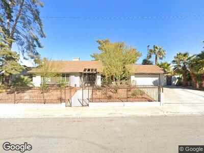
1928 E Viking Rd Unit 13 Las Vegas, NV 89169
Paradise Palms NeighborhoodEstimated Value: $441,019 - $540,000
4
Beds
3
Baths
1,926
Sq Ft
$259/Sq Ft
Est. Value
About This Home
This home is located at 1928 E Viking Rd Unit 13, Las Vegas, NV 89169 and is currently estimated at $499,005, approximately $259 per square foot. 1928 E Viking Rd Unit 13 is a home located in Clark County with nearby schools including Ruby S Thomas Elementary School, William E. Orr Middle School, and Valley High School.
Ownership History
Date
Name
Owned For
Owner Type
Purchase Details
Closed on
Oct 3, 2024
Sold by
Santa Cruz Mark Daniel and King Oliver Lee
Bought by
Mark Daniel Santa Cruz And Oliver Lee King Jr and Santa Cruz
Current Estimated Value
Purchase Details
Closed on
Jan 31, 2022
Sold by
Daniel Santa Cruz Mark
Bought by
Santa Cruz Mark Daniel and King Oliver Lee
Purchase Details
Closed on
Jan 26, 2022
Sold by
Daniel Santa Cruz Mark
Bought by
Santa Cruz Mark Daniel and King Oliver Lee
Purchase Details
Closed on
Jun 18, 2021
Sold by
On Your Marq Inc
Bought by
Santacruz Mark Daniel
Purchase Details
Closed on
Nov 18, 2010
Sold by
Mwm Enterprises Llc
Bought by
On Your Marq Inc
Purchase Details
Closed on
Jul 27, 2010
Sold by
Zezulak Janice M and Zezulak Frank V
Bought by
Zezulak Frank
Purchase Details
Closed on
Jul 13, 2010
Sold by
Zezulak Frank V and Zezulak Janice M
Bought by
Mwm Enterprises Llc
Create a Home Valuation Report for This Property
The Home Valuation Report is an in-depth analysis detailing your home's value as well as a comparison with similar homes in the area
Home Values in the Area
Average Home Value in this Area
Purchase History
| Date | Buyer | Sale Price | Title Company |
|---|---|---|---|
| Mark Daniel Santa Cruz And Oliver Lee King Jr | -- | None Listed On Document | |
| Santa Cruz Mark Daniel | -- | None Listed On Document | |
| Santa Cruz Mark Daniel | -- | None Listed On Document | |
| Santacruz Mark Daniel | $197,386 | None Available | |
| On Your Marq Inc | $145,900 | First American Title Paseo | |
| Mwm Enterprises Llc | $87,900 | First American Title Paseo |
Source: Public Records
Mortgage History
| Date | Status | Borrower | Loan Amount |
|---|---|---|---|
| Previous Owner | Zezulak Frank | $100,000 |
Source: Public Records
Tax History Compared to Growth
Tax History
| Year | Tax Paid | Tax Assessment Tax Assessment Total Assessment is a certain percentage of the fair market value that is determined by local assessors to be the total taxable value of land and additions on the property. | Land | Improvement |
|---|---|---|---|---|
| 2025 | $1,820 | $77,676 | $42,000 | $35,676 |
| 2024 | $1,552 | $77,676 | $42,000 | $35,676 |
| 2023 | $1,552 | $79,175 | $45,150 | $34,025 |
| 2022 | $1,673 | $74,281 | $42,000 | $32,281 |
| 2021 | $1,581 | $69,085 | $37,450 | $31,635 |
| 2020 | $1,417 | $69,640 | $37,450 | $32,190 |
| 2019 | $1,376 | $70,012 | $37,450 | $32,562 |
| 2018 | $1,336 | $71,383 | $39,200 | $32,183 |
| 2017 | $1,751 | $59,690 | $26,250 | $33,440 |
| 2016 | $1,540 | $56,831 | $22,050 | $34,781 |
| 2015 | $1,431 | $44,828 | $16,450 | $28,378 |
| 2014 | $1,223 | $40,475 | $11,550 | $28,925 |
Source: Public Records
Map
Nearby Homes
- 3911 Kamden Way
- 1904 Roxbury Ln
- 1701 E Katie Ave Unit 9
- 1701 E Katie Ave Unit 68
- 1701 E Katie Ave Unit 51
- 1701 E Katie Ave Unit 36
- 1701 E Katie Ave Unit 42
- 1701 E Katie Ave Unit 65
- 1701 E Katie Ave Unit 10
- 1701 E Katie Ave Unit 32
- 1701 E Katie Ave Unit 72
- 3948 Tudur Ln
- 2058 Ottawa Dr
- 2240 Mohigan Way
- 3829 Delaware Ln
- 1631 Ottawa Dr
- 3847 S Eastern Ave
- 3586 Spencer St
- 3597 Cochise Ln
- 1727 Cherokee Ln
- 1928 E Viking Rd Unit 13
- 1908 E Viking Rd
- 1963 Papago Ln
- 1951 Papago Ln
- 1929 Papago Ln
- 1909 Papago Ln
- 1888 E Viking Rd
- 3910 Kamden Way
- 1867 E Viking Rd
- 1877 E Viking Rd
- 1889 Papago Ln
- 1887 E Viking Rd
- 3920 Kamden Way
- 1960 Papago Ln
- 1870 E Viking Rd
- 1944 Papago Ln
- 1976 Papago Ln
- 1871 Papago Ln
- 1897 E Viking Rd
- 1970 Papago Ln