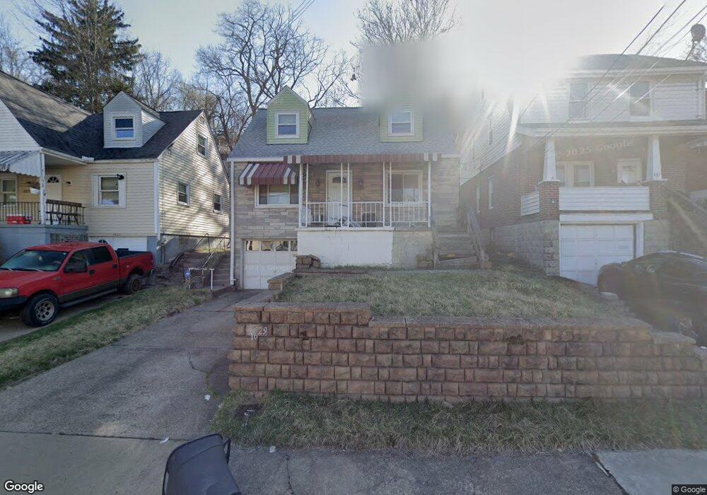
1929 Dartmore St Pittsburgh, PA 15210
Carrick NeighborhoodEstimated Value: $132,669 - $170,000
2
Beds
1
Bath
1,233
Sq Ft
$119/Sq Ft
Est. Value
About This Home
This home is located at 1929 Dartmore St, Pittsburgh, PA 15210 and is currently estimated at $146,417, approximately $118 per square foot. 1929 Dartmore St is a home located in Allegheny County with nearby schools including Pittsburgh Roosevelt K. - 5, Pittsburgh South Brook, and Pittsburgh Carrick High School.
Ownership History
Date
Name
Owned For
Owner Type
Purchase Details
Closed on
Jul 28, 2006
Sold by
Stewardship Fund L P
Bought by
Bova Gary M
Current Estimated Value
Home Financials for this Owner
Home Financials are based on the most recent Mortgage that was taken out on this home.
Original Mortgage
$21,375
Outstanding Balance
$12,791
Interest Rate
6.7%
Mortgage Type
New Conventional
Estimated Equity
$133,626
Purchase Details
Closed on
Jun 29, 2006
Sold by
Destiny Ventures L L C
Bought by
Stewardship Fund L P
Home Financials for this Owner
Home Financials are based on the most recent Mortgage that was taken out on this home.
Original Mortgage
$21,375
Outstanding Balance
$12,791
Interest Rate
6.7%
Mortgage Type
New Conventional
Estimated Equity
$133,626
Purchase Details
Closed on
Aug 27, 1997
Sold by
Storino Timothy and Storino Jean A
Bought by
Weston Wayne A
Create a Home Valuation Report for This Property
The Home Valuation Report is an in-depth analysis detailing your home's value as well as a comparison with similar homes in the area
Home Values in the Area
Average Home Value in this Area
Purchase History
| Date | Buyer | Sale Price | Title Company |
|---|---|---|---|
| Bova Gary M | $22,500 | -- | |
| Stewardship Fund L P | $7,000 | -- | |
| Weston Wayne A | $44,500 | -- |
Source: Public Records
Mortgage History
| Date | Status | Borrower | Loan Amount |
|---|---|---|---|
| Open | Bova Gary M | $21,375 |
Source: Public Records
Tax History Compared to Growth
Tax History
| Year | Tax Paid | Tax Assessment Tax Assessment Total Assessment is a certain percentage of the fair market value that is determined by local assessors to be the total taxable value of land and additions on the property. | Land | Improvement |
|---|---|---|---|---|
| 2025 | $751 | $32,600 | $14,000 | $18,600 |
| 2024 | $751 | $32,600 | $14,000 | $18,600 |
| 2023 | $751 | $32,600 | $14,000 | $18,600 |
| 2022 | $741 | $32,600 | $14,000 | $18,600 |
| 2021 | $741 | $32,600 | $14,000 | $18,600 |
| 2020 | $738 | $32,600 | $14,000 | $18,600 |
| 2019 | $738 | $32,600 | $14,000 | $18,600 |
| 2018 | $499 | $32,600 | $14,000 | $18,600 |
| 2017 | $738 | $32,600 | $14,000 | $18,600 |
| 2016 | $154 | $32,600 | $14,000 | $18,600 |
| 2015 | $154 | $32,600 | $14,000 | $18,600 |
| 2014 | $721 | $32,600 | $14,000 | $18,600 |
Source: Public Records
Map
Nearby Homes
- 1928 Dartmore St
- 373 Copperfield Ave
- 331 Redwood St
- 2082 Walton Ave
- 2032 Jacob St
- 309 Parkfield St
- 1725 Hallowell St
- 42 Queenston St
- 0 Ballinger St Unit 1705904
- 1641 Mount Joseph St
- 1572 Brookline Blvd
- 2220 Jacob St
- 1611 Westmont Ave
- 2000 Brownsville Rd
- 2020 Brownsville Rd
- 2201 Whited St
- 1800 Concordia St
- 1444 Milan Ave
- 12 E Meyers St
- 404 Ariston Ave
- 1933 Dartmore St
- 1927 Dartmore St
- 1935 Dartmore St
- 1925 Dartmore St
- 1939 Dartmore St
- 1928 Fairland St
- 1934 Fairland St
- 1940 Fairland St
- 1920 Dartmore St
- 1926 Dartmore St
- 1932 Dartmore St
- 1932 Dartmore St
- 1932 Dartmore St
- 1922 Dartmore St
- 1943 Dartmore St
- 1925 Fairland St
- 1942 Dartmore St
- 1918 Dartmore St
- 1920 Fairland St
- 1931 Fairland St