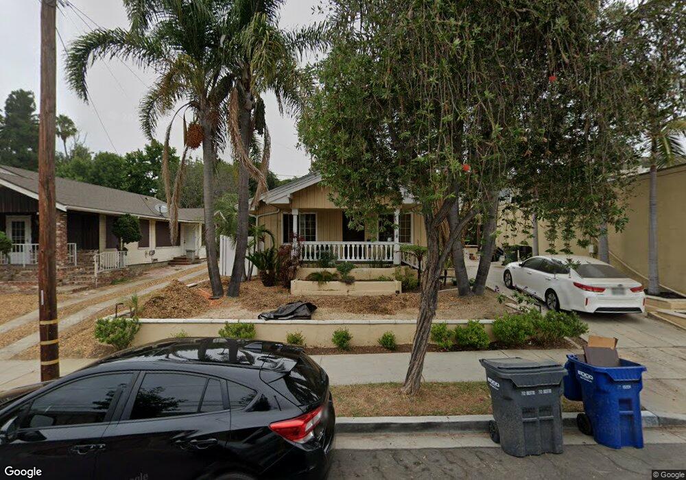
1929 E 21st St Signal Hill, CA 90755
Estimated Value: $800,000 - $968,000
3
Beds
2
Baths
1,494
Sq Ft
$580/Sq Ft
Est. Value
About This Home
This home is located at 1929 E 21st St, Signal Hill, CA 90755 and is currently estimated at $867,059, approximately $580 per square foot. 1929 E 21st St is a home located in Los Angeles County with nearby schools including Alvarado Elementary, Nelson Academy, and Long Beach Polytechnic High School.
Ownership History
Date
Name
Owned For
Owner Type
Purchase Details
Closed on
Nov 29, 2002
Sold by
Laub James C
Bought by
Laub James C
Current Estimated Value
Home Financials for this Owner
Home Financials are based on the most recent Mortgage that was taken out on this home.
Original Mortgage
$176,600
Outstanding Balance
$76,076
Interest Rate
6.28%
Estimated Equity
$790,983
Purchase Details
Closed on
Apr 10, 2001
Sold by
Laub Amalia T
Bought by
Laub James C
Home Financials for this Owner
Home Financials are based on the most recent Mortgage that was taken out on this home.
Original Mortgage
$176,000
Interest Rate
7.14%
Purchase Details
Closed on
Oct 21, 1994
Sold by
Shah Syed M and Shah Samina
Bought by
Mony Naron
Home Financials for this Owner
Home Financials are based on the most recent Mortgage that was taken out on this home.
Original Mortgage
$131,250
Interest Rate
9.87%
Create a Home Valuation Report for This Property
The Home Valuation Report is an in-depth analysis detailing your home's value as well as a comparison with similar homes in the area
Home Values in the Area
Average Home Value in this Area
Purchase History
| Date | Buyer | Sale Price | Title Company |
|---|---|---|---|
| Laub James C | -- | -- | |
| Laub James C | -- | American Title Co | |
| Laub James C | $220,000 | American Title Co | |
| Mony Naron | $175,000 | Commonwealth Land Title Co |
Source: Public Records
Mortgage History
| Date | Status | Borrower | Loan Amount |
|---|---|---|---|
| Open | Laub James C | $176,600 | |
| Previous Owner | Laub James C | $176,000 | |
| Previous Owner | Mony Naron | $131,250 |
Source: Public Records
Tax History
| Year | Tax Paid | Tax Assessment Tax Assessment Total Assessment is a certain percentage of the fair market value that is determined by local assessors to be the total taxable value of land and additions on the property. | Land | Improvement |
|---|---|---|---|---|
| 2025 | $4,655 | $331,479 | $255,247 | $76,232 |
| 2024 | $4,655 | $324,981 | $250,243 | $74,738 |
| 2023 | $4,578 | $318,610 | $245,337 | $73,273 |
| 2022 | $4,316 | $312,364 | $240,527 | $71,837 |
| 2021 | $4,227 | $306,240 | $235,811 | $70,429 |
| 2019 | $4,168 | $297,159 | $228,818 | $68,341 |
| 2018 | $3,996 | $291,333 | $224,332 | $67,001 |
| 2016 | $3,691 | $280,022 | $215,622 | $64,400 |
| 2015 | $3,558 | $275,817 | $212,384 | $63,433 |
| 2014 | $3,540 | $270,415 | $208,224 | $62,191 |
Source: Public Records
Map
Nearby Homes
- 2101 E 21st St Unit 113
- 2101 E 21st St Unit 212
- 2101 E 21st St Unit 306
- 2240 N Legion Dr Unit 217
- 2238 Walnut Ave
- 2240 Walnut Ave
- 1887 Saint Louis Ave
- 1988 Junipero Ave
- 1342 E Wesley Dr
- 1339 E Wesley Dr
- 2341 Walnut Ave
- 1816 Saint Louis Ave
- 1211 E Leigh Ct
- 2420 Gaviota Ave
- 1995 Molino Ave Unit 302
- 1955 Molino Ave
- 2430 Gaviota Ave
- 2115 Ohio Ave
- 2525 E 19th St Unit 24
- 2602 E 20th St Unit 202B
- 1925 E 21st St
- 1919 E 21st St
- 1917 E 21st St
- 1911 E 21st St
- 1905 E 21st St
- 2001 E 21st St
- 2001 E 21st St Unit 122
- 2001 E 21st St Unit 121
- 2001 E 21st St Unit 120
- 2001 E 21st St Unit 320
- 2001 E 21st St Unit 236
- 2001 E 21st St Unit 235
- 2001 E 21st St Unit 234
- 2001 E 21st St Unit 233
- 2001 E 21st St Unit 232
- 2001 E 21st St Unit 231
- 2001 E 21st St Unit 230
- 2001 E 21st St Unit 229
- 2001 E 21st St Unit 228
- 2001 E 21st St Unit 227
Your Personal Tour Guide
Ask me questions while you tour the home.