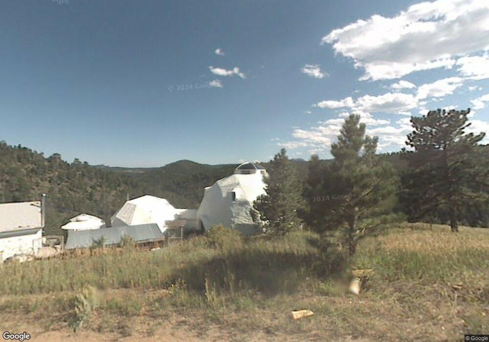
193 Nightshade Dr Boulder, CO 80302
Estimated Value: $681,081 - $999,000
3
Beds
1
Bath
2,096
Sq Ft
$393/Sq Ft
Est. Value
About This Home
This home is located at 193 Nightshade Dr, Boulder, CO 80302 and is currently estimated at $822,770, approximately $392 per square foot. 193 Nightshade Dr is a home located in Boulder County with nearby schools including Nederland Elementary School and Nederland Middle-Senior High School.
Ownership History
Date
Name
Owned For
Owner Type
Purchase Details
Closed on
Dec 8, 2008
Sold by
Pierce Leonard A
Bought by
Pierce Leonard A
Current Estimated Value
Purchase Details
Closed on
Feb 6, 1989
Bought by
Peirce Leonard H and Sumner Lisa A
Purchase Details
Closed on
Mar 13, 1987
Bought by
Peirce Leonard H and Sumner Lisa A
Purchase Details
Closed on
Dec 31, 1985
Bought by
Peirce Leonard H and Sumner Lisa A
Purchase Details
Closed on
Jan 4, 1983
Bought by
Peirce Leonard H and Sumner Lisa A
Create a Home Valuation Report for This Property
The Home Valuation Report is an in-depth analysis detailing your home's value as well as a comparison with similar homes in the area
Purchase History
| Date | Buyer | Sale Price | Title Company |
|---|---|---|---|
| Pierce Leonard A | -- | None Available | |
| Peirce Leonard H | $41,000 | -- | |
| Peirce Leonard H | $93,100 | -- | |
| Peirce Leonard H | $105,000 | -- | |
| Peirce Leonard H | $75,000 | -- |
Source: Public Records
Tax History
| Year | Tax Paid | Tax Assessment Tax Assessment Total Assessment is a certain percentage of the fair market value that is determined by local assessors to be the total taxable value of land and additions on the property. | Land | Improvement |
|---|---|---|---|---|
| 2025 | $3,053 | $39,693 | $11,175 | $28,518 |
| 2024 | $3,053 | $39,693 | $11,175 | $28,518 |
| 2023 | $3,000 | $40,907 | $10,754 | $33,839 |
| 2022 | $2,535 | $33,783 | $8,931 | $24,852 |
| 2021 | $2,508 | $34,755 | $9,188 | $25,567 |
| 2020 | $2,076 | $29,695 | $11,369 | $18,326 |
| 2019 | $2,044 | $29,695 | $11,369 | $18,326 |
| 2018 | $2,066 | $22,738 | $7,992 | $14,746 |
| 2017 | $2,013 | $25,138 | $8,836 | $16,302 |
| 2016 | $2,158 | $23,689 | $8,995 | $14,694 |
| 2015 | $2,046 | $19,733 | $6,766 | $12,967 |
| 2014 | $1,785 | $19,733 | $6,766 | $12,967 |
Source: Public Records
Map
Nearby Homes
- 5566 Sugarloaf Rd
- 548 Coughlin Meadows Rd
- 815 Cougar Run
- 3907 Ridge Rd
- 0 Pennsylvania Gulch Rd
- 280 Hummer Dr
- 880 Hummer Dr
- 11320 Gold Hill Rd
- 136 Old Post Office Rd
- 0 Good Friday Rd
- 730 Lost Angel Rd
- 11780 Gold Hill Rd
- 0 Gold Trail
- 00 County Rd 89 Unit 237
- 718 Emerson Gulch Rd
- 198 Frontier Ln
- 2200 Magnolia Rd
- 300 Shining Star Trail
- 300 Shining Star Trail Unit A
- 280 Rim Rd
- 221 Nightshade Dr
- 230 Nightshade Dr
- 66 Nightshade Dr
- 22 Nightshade Dr
- 0 Primos Rd
- 0 Nightshade Dr
- 465 Nightshade Dr
- 545 Nightshade Dr
- 729 Primos Rd
- 388 Nightshade Dr
- 862 Primos Rd
- 578 Primos Rd
- 184 Nightshade Dr
- 875 Primos Rd
- 1111 Primos Rd
- 458 Nightshade Dr
- 454 Nightshade Dr
- 560 Nightshade Dr
- 900 Primos Rd
- 577 Primos Rd
Your Personal Tour Guide
Ask me questions while you tour the home.