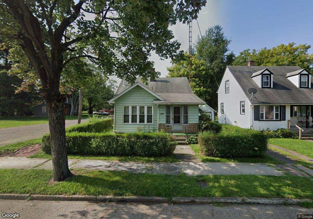
1930 5th St SE Canton, OH 44707
East End North NeighborhoodEstimated Value: $68,941 - $114,000
3
Beds
1
Bath
1,214
Sq Ft
$74/Sq Ft
Est. Value
About This Home
This home is located at 1930 5th St SE, Canton, OH 44707 and is currently estimated at $90,235, approximately $74 per square foot. 1930 5th St SE is a home located in Stark County with nearby schools including Stephanie Rushin Patrick Elementary School, Early Learning Center @ Schreiber, and McKinley High School.
Ownership History
Date
Name
Owned For
Owner Type
Purchase Details
Closed on
Sep 8, 1995
Sold by
Scott Valerie L
Bought by
Quincy Karen L
Current Estimated Value
Home Financials for this Owner
Home Financials are based on the most recent Mortgage that was taken out on this home.
Original Mortgage
$32,300
Interest Rate
7.76%
Mortgage Type
New Conventional
Purchase Details
Closed on
Dec 22, 1988
Purchase Details
Closed on
Nov 4, 1988
Create a Home Valuation Report for This Property
The Home Valuation Report is an in-depth analysis detailing your home's value as well as a comparison with similar homes in the area
Home Values in the Area
Average Home Value in this Area
Purchase History
| Date | Buyer | Sale Price | Title Company |
|---|---|---|---|
| Quincy Karen L | $34,000 | -- | |
| -- | $15,800 | -- | |
| -- | $15,000 | -- |
Source: Public Records
Mortgage History
| Date | Status | Borrower | Loan Amount |
|---|---|---|---|
| Closed | Quincy Karen L | $32,300 |
Source: Public Records
Tax History
| Year | Tax Paid | Tax Assessment Tax Assessment Total Assessment is a certain percentage of the fair market value that is determined by local assessors to be the total taxable value of land and additions on the property. | Land | Improvement |
|---|---|---|---|---|
| 2025 | -- | $17,330 | $3,080 | $14,250 |
| 2024 | -- | $17,330 | $3,080 | $14,250 |
| 2023 | $498 | $8,300 | $1,300 | $7,000 |
| 2022 | $474 | $8,300 | $1,300 | $7,000 |
| 2021 | $491 | $8,300 | $1,300 | $7,000 |
| 2020 | $468 | $7,070 | $1,120 | $5,950 |
| 2019 | $408 | $7,080 | $1,120 | $5,960 |
Source: Public Records
Map
Nearby Homes
- 1747 5th St SE
- 1311 Warner Rd SE
- 319 Crestmont Ave NE
- 515 Flamos Cir NE
- 1431 Sherrick Rd SE
- 429 Gobel Ave NE
- 1427 4th St NE
- 1855 7th St NE
- 0 3rd St SE Unit 5132035
- 1316 4th St NE
- 334 Cornelia Ave NE
- 324 Charlotte Ave SE
- 2630 Squirrel Hollow St NE
- 419 Whitetail Trail NE
- 318 Elmport Ave NE
- 2923 Lincoln St E
- 1014 9th St NE
- 822 Highland Rd NE
- 1002 Cleveland Ave SW
- 1411 Laiblin Place NE
- 1924 5th St SE
- 1920 5th St SE
- 1936 5th St SE
- 1916 5th St SE
- 603 Brad Ave SE
- 1942 5th St SE
- 512 Brad Ave SE
- 1929 5th St SE
- 1923 5th St SE
- 607 Brad Ave SE
- 1948 5th St SE
- 1919 5th St SE
- 1943 5th St SE
- 1913 5th St SE
- 1947 5th St SE
- 1911 5th St SE
- 1916 4th St SE
- 1916 4th St SE
- 606 Hartford Ave SE
- 1954 5th St SE
Your Personal Tour Guide
Ask me questions while you tour the home.