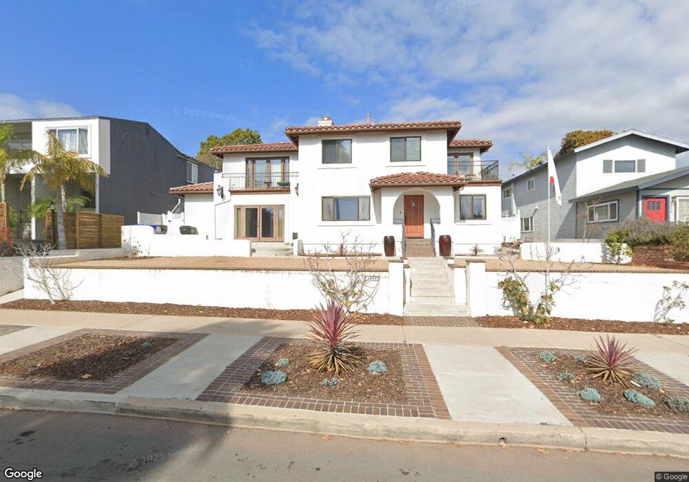
1932 Beryl St San Diego, CA 92109
Pacific Beach NeighborhoodEstimated Value: $2,053,161 - $2,833,000
4
Beds
3
Baths
2,360
Sq Ft
$1,048/Sq Ft
Est. Value
About This Home
This home is located at 1932 Beryl St, San Diego, CA 92109 and is currently estimated at $2,474,290, approximately $1,048 per square foot. 1932 Beryl St is a home located in San Diego County with nearby schools including Sessions Elementary School, Pacific Beach Middle, and Mission Bay High School.
Ownership History
Date
Name
Owned For
Owner Type
Purchase Details
Closed on
May 24, 2023
Sold by
Rand Karl A and Rand Connie J
Bought by
Rand Family Trust
Current Estimated Value
Purchase Details
Closed on
Apr 24, 2003
Sold by
Rand Karl A and Rand Connie J
Bought by
Rand Karl A and Rand Connie J
Home Financials for this Owner
Home Financials are based on the most recent Mortgage that was taken out on this home.
Original Mortgage
$322,700
Interest Rate
5.77%
Purchase Details
Closed on
Jan 3, 1997
Sold by
Lewis Robert L and Lewis Marilyn N
Bought by
Rand Karl A and Rand Connie J
Create a Home Valuation Report for This Property
The Home Valuation Report is an in-depth analysis detailing your home's value as well as a comparison with similar homes in the area
Home Values in the Area
Average Home Value in this Area
Purchase History
| Date | Buyer | Sale Price | Title Company |
|---|---|---|---|
| Rand Family Trust | -- | None Listed On Document | |
| Rand Karl A | -- | American Title Co | |
| Rand Karl A | $187,000 | -- |
Source: Public Records
Mortgage History
| Date | Status | Borrower | Loan Amount |
|---|---|---|---|
| Previous Owner | Rand Karl A | $322,700 |
Source: Public Records
Tax History Compared to Growth
Tax History
| Year | Tax Paid | Tax Assessment Tax Assessment Total Assessment is a certain percentage of the fair market value that is determined by local assessors to be the total taxable value of land and additions on the property. | Land | Improvement |
|---|---|---|---|---|
| 2025 | $6,081 | $509,311 | $86,842 | $422,469 |
| 2024 | $6,081 | $499,326 | $85,140 | $414,186 |
| 2023 | $5,945 | $479,938 | $81,835 | $398,103 |
| 2022 | $5,785 | $479,938 | $81,835 | $398,103 |
| 2021 | $5,744 | $470,529 | $80,231 | $390,298 |
| 2020 | $5,674 | $465,705 | $79,409 | $386,296 |
| 2019 | $5,572 | $456,574 | $77,852 | $378,722 |
| 2018 | $5,208 | $447,623 | $76,326 | $371,297 |
| 2017 | $80 | $438,847 | $74,830 | $364,017 |
| 2016 | $5,000 | $430,243 | $73,363 | $356,880 |
| 2015 | $4,925 | $423,782 | $72,262 | $351,520 |
| 2014 | $4,846 | $415,482 | $70,847 | $344,635 |
Source: Public Records
Map
Nearby Homes
- 1897 Malden St
- 1981 Wilbur Ave
- 1978 Beryl St
- 4964 Kendall St
- 4804 Lamont St
- 1715 Malden St
- 1645 Los Altos Rd
- 2002 Missouri St Unit 6
- 2104 Crownhill Rd
- 4750 Noyes St Unit 110
- 1828 Diamond St Unit 3
- 2020 Diamond St Unit 12
- 4730 Noyes St Unit 106
- 1679-81 Chalcedony St
- 2128 Missouri St
- 1713 Missouri St
- 4600 Lamont St Unit 4-103
- 1885 Diamond St Unit 133
- 1885 Diamond St Unit 2-235
- 1885 Diamond St Unit 2-234