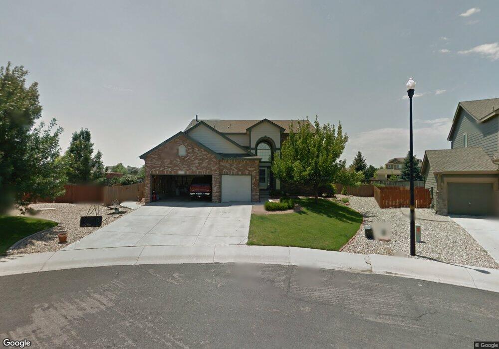
1932 Ruddy Ct Johnstown, CO 80534
Estimated Value: $566,000 - $625,000
3
Beds
3
Baths
2,297
Sq Ft
$257/Sq Ft
Est. Value
About This Home
This home is located at 1932 Ruddy Ct, Johnstown, CO 80534 and is currently estimated at $589,536, approximately $256 per square foot. 1932 Ruddy Ct is a home located in Weld County with nearby schools including Pioneer Ridge Elementary School, Milliken Middle School, and Roosevelt High School.
Ownership History
Date
Name
Owned For
Owner Type
Purchase Details
Closed on
Dec 5, 2001
Sold by
The Ryland Group Inc
Bought by
Messervy Jason B and Messervy Jamalee A
Current Estimated Value
Home Financials for this Owner
Home Financials are based on the most recent Mortgage that was taken out on this home.
Original Mortgage
$245,150
Interest Rate
6.59%
Create a Home Valuation Report for This Property
The Home Valuation Report is an in-depth analysis detailing your home's value as well as a comparison with similar homes in the area
Home Values in the Area
Average Home Value in this Area
Purchase History
| Date | Buyer | Sale Price | Title Company |
|---|---|---|---|
| Messervy Jason B | $281,932 | Cornerstone Title Co |
Source: Public Records
Mortgage History
| Date | Status | Borrower | Loan Amount |
|---|---|---|---|
| Open | Messervy Jason B | $240,000 | |
| Closed | Messervy Jason B | $249,000 | |
| Closed | Messervy Jason B | $233,900 | |
| Closed | Messervy Jason B | $246,575 | |
| Closed | Messervy Jason B | $37,200 | |
| Closed | Messervy Jason B | $245,150 |
Source: Public Records
Tax History Compared to Growth
Tax History
| Year | Tax Paid | Tax Assessment Tax Assessment Total Assessment is a certain percentage of the fair market value that is determined by local assessors to be the total taxable value of land and additions on the property. | Land | Improvement |
|---|---|---|---|---|
| 2025 | $3,237 | $34,780 | $9,380 | $25,400 |
| 2024 | $3,237 | $34,780 | $9,380 | $25,400 |
| 2023 | $3,040 | $36,890 | $5,750 | $31,140 |
| 2022 | $2,816 | $26,250 | $5,840 | $20,410 |
| 2021 | $3,035 | $27,010 | $6,010 | $21,000 |
| 2020 | $2,831 | $25,920 | $5,580 | $20,340 |
| 2019 | $2,214 | $25,920 | $5,580 | $20,340 |
| 2018 | $1,996 | $23,350 | $4,680 | $18,670 |
| 2017 | $2,029 | $23,350 | $4,680 | $18,670 |
| 2016 | $1,884 | $21,670 | $4,300 | $17,370 |
| 2015 | $1,910 | $21,670 | $4,300 | $17,370 |
| 2014 | $1,547 | $18,120 | $3,580 | $14,540 |
Source: Public Records
Map
Nearby Homes
- 2128 Redhead Dr
- 1739 Canvasback Dr
- 370 Saxony Rd
- 1538 Mallard Dr
- 34 Saxony Rd
- 1519 Mallard Dr
- 230 Saxony Rd
- 2507 Rouen Ln
- 139 Muscovey Ln
- 254 Bittern Dr
- 207 Bittern Dr
- 103 Muscovey Ln
- 2724 White Wing Rd
- 2708 Aylesbury Way
- 2683 Pochard Ct
- 2726 Aylesbury Way
- 3000 Panorama Ct
- 3020 Panorama Ct
- 3060 Panorama Ct
- 3081 Panorama Ct
- 1926 Ruddy Ct
- 1943 Ruddy Ct
- 1920 Ruddy Ct
- 1937 Ruddy Ct
- 1931 Ruddy Ct
- 1914 Ruddy Ct
- 1925 Ruddy Ct
- 1919 Ruddy Ct
- 1944 Wood Duck Dr
- 1938 Wood Duck Dr
- 1913 Ruddy Ct
- 1926 Wood Duck Dr
- 1920 Wood Duck Dr
- 1907 Ruddy Ct
- 20969 County Road 17
- 1914 Wood Duck Dr
- 1937 Green Wing Dr
- 1908 Wood Duck Dr
- 1925 Green Wing Dr
- 1847 Wood Duck Dr