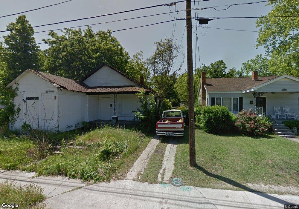
1936 Greene St Augusta, GA 30904
Harrisburg NeighborhoodEstimated Value: $20,000 - $93,000
2
Beds
1
Bath
1,060
Sq Ft
$58/Sq Ft
Est. Value
About This Home
This home is located at 1936 Greene St, Augusta, GA 30904 and is currently estimated at $61,667, approximately $58 per square foot. 1936 Greene St is a home located in Richmond County with nearby schools including Lamar Elementary School, W.S. Hornsby K-8 School, and Johnson Magnet.
Ownership History
Date
Name
Owned For
Owner Type
Purchase Details
Closed on
Jul 25, 2019
Sold by
Augusta Georgia Land Bank Authority
Bought by
Fireside Restorations Llc
Current Estimated Value
Purchase Details
Closed on
Jun 20, 2019
Sold by
Jenkins Charlie R
Bought by
Augusta Georgia Land Bank Authority
Purchase Details
Closed on
Jan 23, 1995
Sold by
Channell Cliff
Bought by
Russell Walter E Russell Denise L
Purchase Details
Closed on
Oct 19, 1993
Sold by
Rychlik Joseph Rychlik Ronald T
Bought by
Channell Cliff
Purchase Details
Closed on
May 22, 1992
Sold by
Channell Cliff
Bought by
Rychlik Joseph Rychlik Ronald T
Purchase Details
Closed on
May 23, 1989
Sold by
Trust Company Bank Of Augusta N A
Bought by
Channell Cliff
Create a Home Valuation Report for This Property
The Home Valuation Report is an in-depth analysis detailing your home's value as well as a comparison with similar homes in the area
Home Values in the Area
Average Home Value in this Area
Purchase History
| Date | Buyer | Sale Price | Title Company |
|---|---|---|---|
| Fireside Restorations Llc | $1,200 | -- | |
| Augusta Georgia Land Bank Authority | $9,119 | -- | |
| Russell Walter E Russell Denise L | $22,900 | -- | |
| Channell Cliff | $17,000 | -- | |
| Rychlik Joseph Rychlik Ronald T | $17,000 | -- | |
| Channell Cliff | -- | -- |
Source: Public Records
Tax History Compared to Growth
Tax History
| Year | Tax Paid | Tax Assessment Tax Assessment Total Assessment is a certain percentage of the fair market value that is determined by local assessors to be the total taxable value of land and additions on the property. | Land | Improvement |
|---|---|---|---|---|
| 2024 | $93 | $2,885 | $2,885 | $0 |
| 2023 | $79 | $2,885 | $2,885 | $0 |
| 2022 | $78 | $2,559 | $2,559 | $0 |
| 2021 | $97 | $2,891 | $2,891 | $0 |
| 2020 | $16 | $8,258 | $3,960 | $4,298 |
| 2019 | $300 | $8,473 | $3,960 | $4,513 |
| 2018 | $303 | $8,473 | $3,960 | $4,513 |
| 2017 | $359 | $8,473 | $3,960 | $4,513 |
| 2016 | $301 | $8,473 | $3,960 | $4,513 |
| 2015 | $459 | $8,473 | $3,960 | $4,513 |
| 2014 | $504 | $8,473 | $3,960 | $4,513 |
Source: Public Records
Map
Nearby Homes
- 1940 Telfair St
- 1916 Battle Row
- 1918 Walker St
- 1916 Walker St
- 608 Eve St
- 1968 Battle Row
- 1913 Ellis St
- 2021 Ellis St
- 1929 Watkins St
- 2025 Ellis St
- 605 Eve St
- 1915 Watkins St
- 1858 Walker St
- 1918 Division St Unit 3
- 1827 Hicks St
- 2056 Telfair St
- 1851 Wilhelm Ln
- 1825 Watkins St
- 2006 Division St
- 1838 Watkins St
- 1940 Greene St
- 1934 Greene St
- 1934 Greene St Unit 1
- 1942 Greene St
- 1932 Greene St
- 1942A Greene St
- 1942 1/2 Greene St
- 1933 Telfair St
- 1935 Telfair St
- 1929 Telfair St
- 1939 Telfair St
- 1946 Greene St
- 1926 Greene St
- 1927 Telfair St
- 1941 Telfair St
- 1952 Greene St
- 1925 Telfair St
- 1922 Greene St
- 1943 Telfair St
- 1954 Greene St