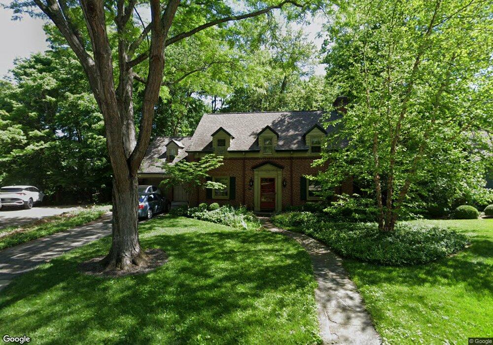
1937 Gregory Ln Cincinnati, OH 45206
East Walnut Hills NeighborhoodEstimated Value: $501,000 - $781,000
3
Beds
3
Baths
2,135
Sq Ft
$295/Sq Ft
Est. Value
About This Home
This home is located at 1937 Gregory Ln, Cincinnati, OH 45206 and is currently estimated at $629,749, approximately $294 per square foot. 1937 Gregory Ln is a home located in Hamilton County with nearby schools including Evanston Academy Elementary School, Clark Montessori High School, and Robert A. Taft Information Technology High School.
Ownership History
Date
Name
Owned For
Owner Type
Purchase Details
Closed on
Oct 7, 2021
Sold by
Fullen Thomas L
Bought by
Fullen Thomas L and Thomas L Fullen Revocable Trus
Current Estimated Value
Purchase Details
Closed on
Jan 6, 1995
Sold by
Haydock Thomas C and Haydock Sharon L
Bought by
Fullen Thomas L and Wesling Susan M
Home Financials for this Owner
Home Financials are based on the most recent Mortgage that was taken out on this home.
Original Mortgage
$160,000
Interest Rate
9.23%
Create a Home Valuation Report for This Property
The Home Valuation Report is an in-depth analysis detailing your home's value as well as a comparison with similar homes in the area
Home Values in the Area
Average Home Value in this Area
Purchase History
| Date | Buyer | Sale Price | Title Company |
|---|---|---|---|
| Fullen Thomas L | -- | None Available | |
| Fullen Thomas L | -- | -- |
Source: Public Records
Mortgage History
| Date | Status | Borrower | Loan Amount |
|---|---|---|---|
| Closed | Fullen Thomas L | $160,000 |
Source: Public Records
Tax History
| Year | Tax Paid | Tax Assessment Tax Assessment Total Assessment is a certain percentage of the fair market value that is determined by local assessors to be the total taxable value of land and additions on the property. | Land | Improvement |
|---|---|---|---|---|
| 2025 | $8,241 | $144,040 | $51,300 | $92,740 |
| 2024 | $7,994 | $144,040 | $51,300 | $92,740 |
| 2023 | $8,226 | $144,040 | $51,300 | $92,740 |
| 2022 | $8,424 | $132,640 | $45,787 | $86,853 |
| 2021 | $8,096 | $132,640 | $45,787 | $86,853 |
| 2020 | $8,350 | $132,640 | $45,787 | $86,853 |
| 2019 | $8,484 | $123,963 | $42,791 | $81,172 |
| 2018 | $8,497 | $123,963 | $42,791 | $81,172 |
| 2017 | $8,065 | $123,963 | $42,791 | $81,172 |
| 2016 | $8,446 | $127,820 | $57,246 | $70,574 |
| 2015 | $7,621 | $127,820 | $57,246 | $70,574 |
| 2014 | $7,676 | $127,820 | $57,246 | $70,574 |
| 2013 | $7,366 | $112,123 | $50,215 | $61,908 |
Source: Public Records
Map
Nearby Homes
- 2957 Annwood St
- 1906 Pogue Ave
- 1998 Fairfax Ave
- 1909 Pogue Ave
- 1989 Kinney Ave
- 1930 Kinney Ave
- 1933 Hewitt Ave
- 3235 Wold Ave
- 3048 O Bryon St
- 3314 Wabash Ave
- 2120 Pogue Ave
- 1815 Kinney Ave
- 1839 Hewitt Ave
- 3330 Evanston Ave
- 3014 Cleinview Ave
- 18 Elmhurst Place
- 3346 Bonaparte Ave
- 3419 Trimble Ave
- 3336 Graydon Ave
- 1814 Hewitt Ave
Your Personal Tour Guide
Ask me questions while you tour the home.