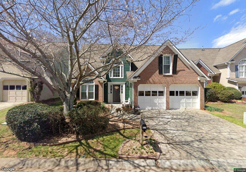
1939 Briar Pond Way Marietta, GA 30066
Northwestern Marietta NeighborhoodEstimated Value: $420,000 - $453,000
3
Beds
3
Baths
1,875
Sq Ft
$231/Sq Ft
Est. Value
About This Home
This home is located at 1939 Briar Pond Way, Marietta, GA 30066 and is currently estimated at $433,430, approximately $231 per square foot. 1939 Briar Pond Way is a home located in Cobb County with nearby schools including Sawyer Road Elementary School, Marietta Sixth Grade Academy, and Marietta Middle School.
Ownership History
Date
Name
Owned For
Owner Type
Purchase Details
Closed on
Jul 10, 2002
Sold by
Koob Cheryl L
Bought by
Jarvis Cheryl L
Current Estimated Value
Home Financials for this Owner
Home Financials are based on the most recent Mortgage that was taken out on this home.
Original Mortgage
$139,920
Outstanding Balance
$46,849
Interest Rate
3.88%
Mortgage Type
New Conventional
Estimated Equity
$386,581
Create a Home Valuation Report for This Property
The Home Valuation Report is an in-depth analysis detailing your home's value as well as a comparison with similar homes in the area
Home Values in the Area
Average Home Value in this Area
Purchase History
| Date | Buyer | Sale Price | Title Company |
|---|---|---|---|
| Jarvis Cheryl L | $174,900 | -- |
Source: Public Records
Mortgage History
| Date | Status | Borrower | Loan Amount |
|---|---|---|---|
| Open | Jarvis Cheryl L | $139,920 |
Source: Public Records
Tax History Compared to Growth
Tax History
| Year | Tax Paid | Tax Assessment Tax Assessment Total Assessment is a certain percentage of the fair market value that is determined by local assessors to be the total taxable value of land and additions on the property. | Land | Improvement |
|---|---|---|---|---|
| 2025 | $420 | $178,984 | $40,000 | $138,984 |
| 2024 | $420 | $178,984 | $40,000 | $138,984 |
| 2023 | $268 | $153,284 | $32,800 | $120,484 |
| 2022 | $420 | $121,200 | $30,000 | $91,200 |
| 2021 | $433 | $102,224 | $24,000 | $78,224 |
| 2020 | $433 | $102,224 | $24,000 | $78,224 |
| 2019 | $433 | $102,224 | $24,000 | $78,224 |
| 2018 | $431 | $86,144 | $20,000 | $66,144 |
| 2017 | $346 | $80,860 | $18,000 | $62,860 |
| 2016 | $349 | $80,860 | $18,000 | $62,860 |
| 2015 | $380 | $69,516 | $18,000 | $51,516 |
| 2014 | $393 | $69,516 | $0 | $0 |
Source: Public Records
Map
Nearby Homes
- 1425 Rosewood Creek Dr
- 1871 Chardin Way
- 1800 Chardin Way
- 1716 Chanson Place
- 1490 Longwing Ln
- 1924 Wilkenson Crossing
- 1599 Cambridge Place
- 1834 Butterfly NE
- 1834 Butterfly Way
- 1593 Pinebreeze Dr
- 1838 Butterfly NE
- 1850 Butterfly Way NE
- 1386 Valmont Trace NE
- Robie Plan at The Village at Sandy Plains
- Harbor Plan at The Village at Sandy Plains
- Hanover Plan at The Village at Sandy Plains
- Bowen Plan at The Village at Sandy Plains
- Elston Plan at The Village at Sandy Plains
- BALDWIN Plan at The Village at Sandy Plains
- 1854 Butterfly Way
- 1935 Briar Pond Way
- 1943 Briar Pond Way
- 2080 Drogheda Ln
- 2084 Drogheda Ln
- 1947 Briar Pond Way
- 1931 Briar Pond Way
- 2076 Drogheda Ln
- 2088 Drogheda Ln
- 1936 Briar Pond Way
- 1940 Briar Pond Way
- 1932 Briar Pond Way
- 1927 Briar Pond Way
- 2072 Drogheda Ln
- 296 Drogheda Ln Unit 3
- 2092 Drogheda Ln
- 1944 Briar Pond Way
- 1928 Briar Pond Way Unit 68
- 1928 Briar Pond Way
- 2068 Drogheda Ln
- 2012 Drogheda Ln