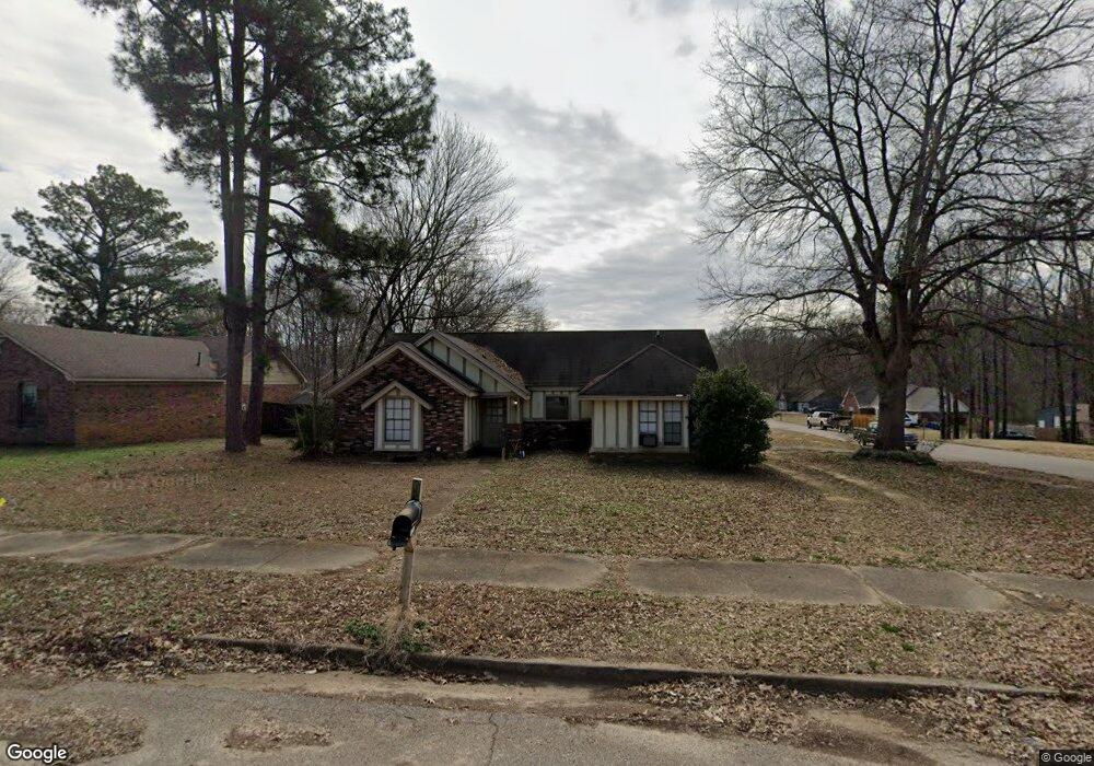
1939 Tissington Dr Horn Lake, MS 38637
Estimated Value: $202,000 - $225,000
3
Beds
2
Baths
1,403
Sq Ft
$150/Sq Ft
Est. Value
About This Home
This home is located at 1939 Tissington Dr, Horn Lake, MS 38637 and is currently estimated at $210,755, approximately $150 per square foot. 1939 Tissington Dr is a home located in DeSoto County with nearby schools including Horn Lake Elementary School, Horn Lake Intermediate School, and Horn Lake Middle School.
Ownership History
Date
Name
Owned For
Owner Type
Purchase Details
Closed on
Oct 30, 2017
Sold by
Rollins Hallie E
Bought by
North Mississippi Real Est Management Ll
Current Estimated Value
Purchase Details
Closed on
Mar 21, 2014
Sold by
Ammar Ammar
Bought by
Rollins Hallie E
Purchase Details
Closed on
Sep 10, 2010
Sold by
Secretary Of Housing & Urban Development
Bought by
Ammar Ammar
Home Financials for this Owner
Home Financials are based on the most recent Mortgage that was taken out on this home.
Original Mortgage
$47,840
Interest Rate
4.52%
Mortgage Type
Purchase Money Mortgage
Create a Home Valuation Report for This Property
The Home Valuation Report is an in-depth analysis detailing your home's value as well as a comparison with similar homes in the area
Home Values in the Area
Average Home Value in this Area
Purchase History
| Date | Buyer | Sale Price | Title Company |
|---|---|---|---|
| North Mississippi Real Est Management Ll | -- | First National Financial Tit | |
| Rollins Hallie E | -- | None Available | |
| Ammar Ammar | -- | None Available |
Source: Public Records
Mortgage History
| Date | Status | Borrower | Loan Amount |
|---|---|---|---|
| Previous Owner | Ammar Ammar | $47,840 |
Source: Public Records
Tax History Compared to Growth
Tax History
| Year | Tax Paid | Tax Assessment Tax Assessment Total Assessment is a certain percentage of the fair market value that is determined by local assessors to be the total taxable value of land and additions on the property. | Land | Improvement |
|---|---|---|---|---|
| 2024 | $1,899 | $12,783 | $2,700 | $10,083 |
| 2023 | $1,899 | $12,783 | $0 | $0 |
| 2022 | $1,899 | $12,783 | $2,700 | $10,083 |
| 2021 | $1,899 | $12,783 | $2,700 | $10,083 |
| 2020 | $1,780 | $11,976 | $2,700 | $9,276 |
| 2019 | $1,780 | $11,976 | $2,700 | $9,276 |
| 2017 | $1,740 | $20,598 | $11,649 | $8,949 |
| 2016 | $1,693 | $11,649 | $2,700 | $8,949 |
| 2015 | $1,686 | $20,598 | $11,649 | $8,949 |
| 2014 | $1,693 | $11,649 | $0 | $0 |
| 2013 | $1,647 | $11,649 | $0 | $0 |
Source: Public Records
Map
Nearby Homes
- 1926 Tissington Dr
- 1939 Ingleside Cove
- 1876 Greeno Dr
- 5240 Park Place Dr
- 1784 Thomas St
- 2065 Tall Tree Dr
- 1664 Thomas St
- 1652 Thomas St
- 2095 Tall Tree Dr
- 5393 Peppermill Dr
- 5381 Peppermill Dr
- 2155 Church Rd
- 4925 Winesap Dr
- 2515 Bryce Cove
- 6275 U S Highway 51
- 1628 Joy Blvd
- 5822 Waverly Dr
- 2605 Valleybrook Rd
- 6265 Foxbriar Dr
- 6433 Arbor Lake Dr W
- 1925 Tissington Dr
- 1971 Tissington Dr
- 1913 Tissington Dr
- 5520 Cohay Dr
- 1940 Tissington Dr
- 1954 Tissington Dr
- 1972 Tissington Dr
- 1914 Tissington Dr
- 5531 Cohay Dr
- 1899 Tissington Dr
- 1982 Tissington Dr
- 1900 Tissington Dr
- 2001 Tissington Dr
- 5521 Cohay Dr
- 1925 Ingleside Cove
- 1953 Ingleside Cove
- 1885 Tissington Dr
- 5496 Cohay Dr
- 1969 Ingleside Cove
- 1915 Ingleside Cove