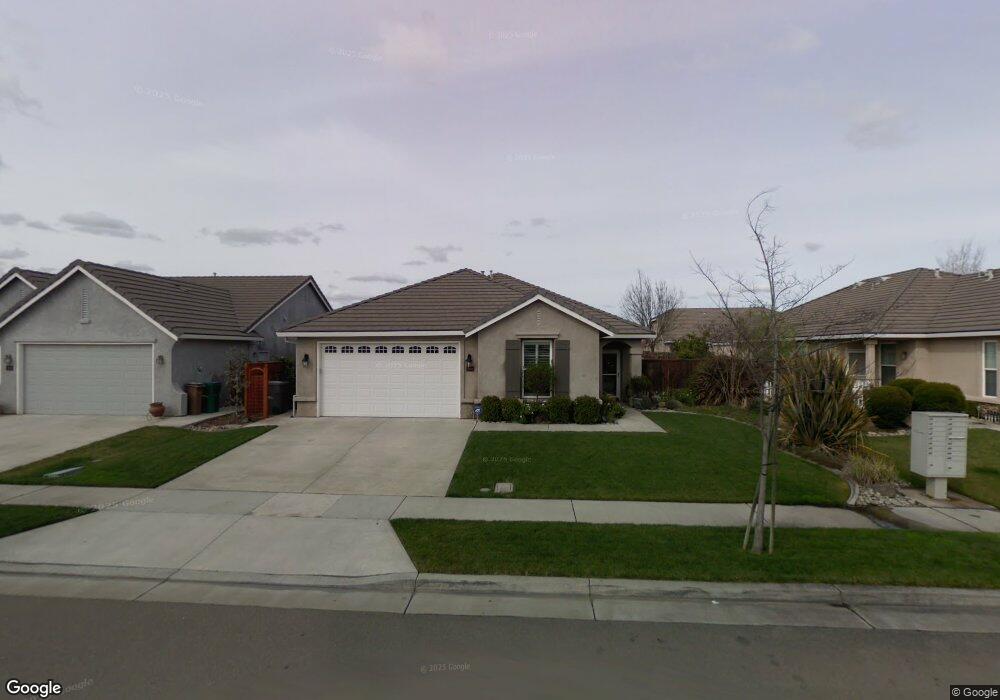
1939 Wyndham Way Lodi, CA 95242
Central Lodi NeighborhoodEstimated Value: $458,000 - $562,000
3
Beds
2
Baths
1,968
Sq Ft
$267/Sq Ft
Est. Value
About This Home
This home is located at 1939 Wyndham Way, Lodi, CA 95242 and is currently estimated at $526,096, approximately $267 per square foot. 1939 Wyndham Way is a home located in San Joaquin County with nearby schools including Ellerth E. Larson Elementary School, Lodi Middle School, and Tokay High School.
Ownership History
Date
Name
Owned For
Owner Type
Purchase Details
Closed on
Jul 18, 2019
Sold by
Calzada Ronald and Calzada Kelly
Bought by
Calzada Ronald and Calzada Kelly
Current Estimated Value
Purchase Details
Closed on
Dec 2, 2002
Sold by
Harney Development Llc
Bought by
Calzada Ronald and Calzada Kelly
Home Financials for this Owner
Home Financials are based on the most recent Mortgage that was taken out on this home.
Original Mortgage
$163,600
Interest Rate
6.06%
Create a Home Valuation Report for This Property
The Home Valuation Report is an in-depth analysis detailing your home's value as well as a comparison with similar homes in the area
Home Values in the Area
Average Home Value in this Area
Purchase History
| Date | Buyer | Sale Price | Title Company |
|---|---|---|---|
| Calzada Ronald | -- | None Available | |
| Calzada Ronald | $247,500 | Chicago Title Co |
Source: Public Records
Mortgage History
| Date | Status | Borrower | Loan Amount |
|---|---|---|---|
| Closed | Calzada Ronald | $163,600 |
Source: Public Records
Tax History
| Year | Tax Paid | Tax Assessment Tax Assessment Total Assessment is a certain percentage of the fair market value that is determined by local assessors to be the total taxable value of land and additions on the property. | Land | Improvement |
|---|---|---|---|---|
| 2025 | $3,806 | $357,787 | $107,167 | $250,620 |
| 2024 | $3,701 | $350,772 | $105,066 | $245,706 |
| 2023 | $3,657 | $343,895 | $103,006 | $240,889 |
| 2022 | $3,574 | $337,153 | $100,987 | $236,166 |
| 2021 | $3,637 | $330,543 | $99,007 | $231,536 |
| 2020 | $3,542 | $327,154 | $97,992 | $229,162 |
| 2019 | $3,469 | $320,740 | $96,071 | $224,669 |
| 2018 | $3,419 | $314,452 | $94,188 | $220,264 |
| 2017 | $3,342 | $308,288 | $92,342 | $215,946 |
| 2016 | $3,131 | $302,246 | $90,532 | $211,714 |
| 2014 | $3,054 | $291,878 | $87,427 | $204,451 |
Source: Public Records
Map
Nearby Homes
- 2047 Katnich Ln
- 1623 Richmond Ln
- 1959 Yorktown Dr
- 2071 Snowbird Dr
- 2246 Katzakian Way
- 1901 S Mills Ave Unit 3
- 2457 Rockingham Cir
- 1754 Lakeshore Dr
- 2340 Bellows Way
- 2448 Satin Leaf St
- 2460 Satin Leaf St
- 1714 Willow Point Ct
- 1123 W Harney Ln
- 1734 Bonnard Way
- 2509 Persimmon St
- 2517 Grove St
- 1050 Bradford Cir
- 2628 Persimmon St
- 2635 Hickory Ln
- 2633 Persimmon St
- 1933 Wyndham Way
- 1945 Wyndham Way
- 1934 Millbrook Dr
- 1940 Millbrook Dr
- 1927 Wyndham Way
- 1951 Wyndham Way
- 1928 Millbrook Dr
- 1946 Millbrook Dr
- 1922 Millbrook Dr
- 1942 Wyndham Way
- 1936 Wyndham Way
- 1948 Wyndham Way
- 1921 Wyndham Way
- 1957 Wyndham Way
- 1954 Wyndham Way
- 1930 Wyndham Way
- 1916 Millbrook Dr
- 1952 Millbrook Dr
- 1915 Wyndham Way
- 1960 Wyndham Way
Your Personal Tour Guide
Ask me questions while you tour the home.