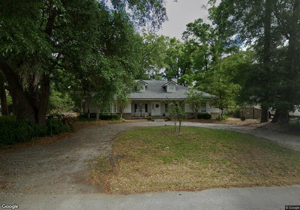
1941 Biggers Rd Jacksonville, FL 32216
Sans Souci NeighborhoodEstimated Value: $378,229 - $433,000
3
Beds
3
Baths
2,363
Sq Ft
$171/Sq Ft
Est. Value
About This Home
This home is located at 1941 Biggers Rd, Jacksonville, FL 32216 and is currently estimated at $403,057, approximately $170 per square foot. 1941 Biggers Rd is a home located in Duval County with nearby schools including Hogan-Spring Glen Elementary School, Southside Middle School, and Englewood High School.
Ownership History
Date
Name
Owned For
Owner Type
Purchase Details
Closed on
Sep 7, 2001
Sold by
Darsey Randall W and Darsey Deena K
Bought by
Brady Evelyn K
Current Estimated Value
Home Financials for this Owner
Home Financials are based on the most recent Mortgage that was taken out on this home.
Original Mortgage
$108,450
Interest Rate
6.98%
Mortgage Type
Purchase Money Mortgage
Create a Home Valuation Report for This Property
The Home Valuation Report is an in-depth analysis detailing your home's value as well as a comparison with similar homes in the area
Home Values in the Area
Average Home Value in this Area
Purchase History
| Date | Buyer | Sale Price | Title Company |
|---|---|---|---|
| Brady Evelyn K | $178,500 | -- |
Source: Public Records
Mortgage History
| Date | Status | Borrower | Loan Amount |
|---|---|---|---|
| Closed | Brady Evelyn K | $108,450 |
Source: Public Records
Tax History
| Year | Tax Paid | Tax Assessment Tax Assessment Total Assessment is a certain percentage of the fair market value that is determined by local assessors to be the total taxable value of land and additions on the property. | Land | Improvement |
|---|---|---|---|---|
| 2026 | $2,463 | $190,277 | -- | -- |
| 2025 | $2,215 | $190,277 | -- | -- |
| 2024 | $2,133 | $184,915 | -- | -- |
| 2023 | $2,133 | $179,530 | $0 | $0 |
| 2022 | $1,900 | $174,301 | $0 | $0 |
| 2021 | $1,871 | $169,225 | $0 | $0 |
| 2020 | $2,132 | $166,889 | $0 | $0 |
| 2019 | $2,101 | $163,137 | $0 | $0 |
| 2018 | $2,067 | $160,096 | $0 | $0 |
| 2017 | $2,035 | $156,804 | $0 | $0 |
| 2016 | $2,228 | $149,435 | $0 | $0 |
| 2015 | $2,249 | $148,397 | $0 | $0 |
| 2014 | $2,251 | $147,220 | $0 | $0 |
Source: Public Records
Map
Nearby Homes
- 1950 Jason Scott Dr
- 2085 Mills Rd
- 8080 Ibach Rd
- 2323 Parental Home Rd
- 2736 Jewell Rd
- 2115 East Rd
- 8628 Blarney Stone Ct
- 2823 Jewell Rd
- 7341 El Ocho Rd Unit 1
- 2806 Hilsdale Harbor Way
- 1768 El Camino Rd Unit 7
- 7319 Pottsburg Dr Unit 2
- 1716 El Camino Rd Unit 3
- 1707 El Prado Rd Unit 3
- 1738 El Prado Rd Unit 8
- 1738 El Prado Rd Unit 5
- 1714 El Prado Rd Unit 1
- 3452 Killarney Dr
- 1713 El Camino Rd Unit 7
- 1644 El Camino Rd Unit 5
- 1991 Biggers Rd
- 1931 Biggers Rd
- 1970 Biggers Rd
- 1958 Biggers Rd
- 2010 Mills Rd
- 1968 Mills Rd
- 1923 Biggers Rd
- 1938 Biggers Rd
- 1950 Mills Rd
- 1966 Jason Scott Dr
- 2042 Mills Rd
- 2003 Mills Rd
- 2023 Mills Rd
- 8206 Hogan Rd
- 1958 Jason Scott Dr
- 8220 Hogan Rd
- 1942 Jason Scott Dr
- 8228 Hogan Rd
- 1934 Jason Scott Dr
- 1910 Jason Scott Dr
Your Personal Tour Guide
Ask me questions while you tour the home.