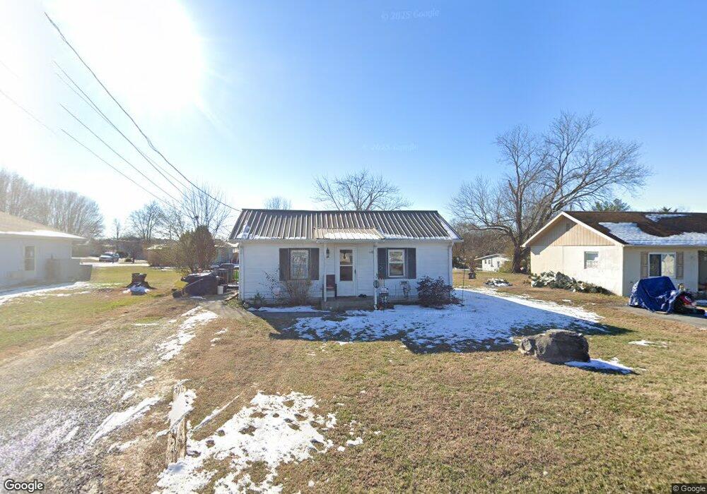
1941 Maple St White Pine, TN 37890
Estimated Value: $138,000 - $189,000
Studio
1
Bath
841
Sq Ft
$189/Sq Ft
Est. Value
About This Home
This home is located at 1941 Maple St, White Pine, TN 37890 and is currently estimated at $158,533, approximately $188 per square foot. 1941 Maple St is a home located in Jefferson County with nearby schools including Cornerstone Christian Academy and Lakeway Christian Academy.
Ownership History
Date
Name
Owned For
Owner Type
Purchase Details
Closed on
Aug 28, 2017
Sold by
Lind Wayne A
Bought by
Waddell Elbert L and Waddell Carol M
Current Estimated Value
Purchase Details
Closed on
Aug 24, 2017
Sold by
Lind Wayne A
Bought by
Waddell Elbert L and Waddell Carol M
Purchase Details
Closed on
May 2, 2014
Sold by
Waddell Elbert L
Bought by
Lind Wayne A
Home Financials for this Owner
Home Financials are based on the most recent Mortgage that was taken out on this home.
Original Mortgage
$44,000
Interest Rate
4.44%
Mortgage Type
New Conventional
Purchase Details
Closed on
Jan 25, 1984
Bought by
Waddell Elbert L and Waddell Carole M
Create a Home Valuation Report for This Property
The Home Valuation Report is an in-depth analysis detailing your home's value as well as a comparison with similar homes in the area
Purchase History
| Date | Buyer | Sale Price | Title Company |
|---|---|---|---|
| Waddell Elbert L | $25,000 | None Available | |
| Waddell Elbert L | -- | -- | |
| Lind Wayne A | $45,000 | -- | |
| Waddell Elbert L | -- | -- |
Source: Public Records
Mortgage History
| Date | Status | Borrower | Loan Amount |
|---|---|---|---|
| Previous Owner | Lind Wayne A | $44,000 |
Source: Public Records
Tax History
| Year | Tax Paid | Tax Assessment Tax Assessment Total Assessment is a certain percentage of the fair market value that is determined by local assessors to be the total taxable value of land and additions on the property. | Land | Improvement |
|---|---|---|---|---|
| 2025 | $392 | $27,925 | $7,500 | $20,425 |
| 2022 | $483 | $14,800 | $5,750 | $9,050 |
| 2021 | $483 | $14,800 | $5,750 | $9,050 |
| 2020 | $483 | $14,800 | $5,750 | $9,050 |
| 2019 | $483 | $14,800 | $5,750 | $9,050 |
| 2018 | $442 | $12,400 | $4,500 | $7,900 |
| 2017 | $442 | $12,400 | $4,500 | $7,900 |
| 2016 | $440 | $12,400 | $4,500 | $7,900 |
| 2015 | $438 | $12,400 | $4,500 | $7,900 |
| 2014 | $436 | $12,400 | $4,500 | $7,900 |
Source: Public Records
Map
Nearby Homes
- TBD Creamery St
- 0 Creamery St
- OFF Jefferson St
- 1723 Guy St
- 1207 Bolling St
- 3111 Cecelia St
- 3215 Melody Ln
- 1506 Moyers St
- 1605 College St
- 3207 Dove Ln
- 1520 State St
- 1015 Pratt Dr
- 2026 Jonathan Dr
- 1024 Rosella Dr
- 0 Baker Springs Rd Unit 11640745
- 1127 Rosella Dr
- 1328 Main St
- 949 U S 25e
- 1006 Rachel Dr
- 1050 Rachel Dr
Your Personal Tour Guide
Ask me questions while you tour the home.