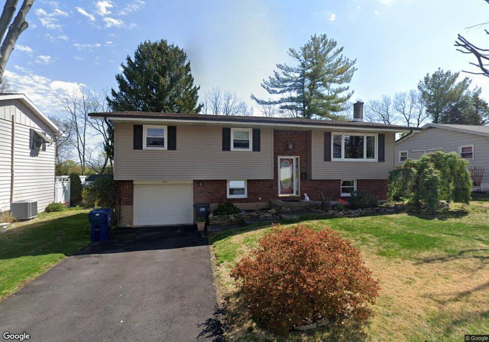
1941 N 20th St Allentown, PA 18104
South Whitehall Township NeighborhoodEstimated Value: $328,932 - $369,000
3
Beds
2
Baths
1,434
Sq Ft
$243/Sq Ft
Est. Value
About This Home
This home is located at 1941 N 20th St, Allentown, PA 18104 and is currently estimated at $348,733, approximately $243 per square foot. 1941 N 20th St is a home located in Lehigh County with nearby schools including Kratzer Elementary School, Orefield Middle School, and Parkland High School.
Ownership History
Date
Name
Owned For
Owner Type
Purchase Details
Closed on
Sep 29, 1998
Sold by
Santa Joseph A and Santa Lori J
Bought by
Kehl Michael A and Kehl Cheryl A
Current Estimated Value
Purchase Details
Closed on
Jun 16, 1993
Sold by
Santa Adolf
Bought by
Santa Joseph A and Santa Lori J
Purchase Details
Closed on
Mar 30, 1988
Sold by
Santa Adolf and Santa Anna
Bought by
Santa Adolf
Purchase Details
Closed on
Mar 31, 1980
Bought by
Santa Adolf and Santa Anna
Create a Home Valuation Report for This Property
The Home Valuation Report is an in-depth analysis detailing your home's value as well as a comparison with similar homes in the area
Home Values in the Area
Average Home Value in this Area
Purchase History
| Date | Buyer | Sale Price | Title Company |
|---|---|---|---|
| Kehl Michael A | $116,000 | -- | |
| Santa Joseph A | -- | -- | |
| Santa Adolf | -- | -- | |
| Santa Adolf | $58,500 | -- |
Source: Public Records
Tax History Compared to Growth
Tax History
| Year | Tax Paid | Tax Assessment Tax Assessment Total Assessment is a certain percentage of the fair market value that is determined by local assessors to be the total taxable value of land and additions on the property. | Land | Improvement |
|---|---|---|---|---|
| 2025 | $3,648 | $150,000 | $32,400 | $117,600 |
| 2024 | $3,525 | $150,000 | $32,400 | $117,600 |
| 2023 | $3,450 | $150,000 | $32,400 | $117,600 |
| 2022 | $3,436 | $150,000 | $117,600 | $32,400 |
| 2021 | $3,436 | $150,000 | $32,400 | $117,600 |
| 2020 | $3,436 | $150,000 | $32,400 | $117,600 |
| 2019 | $3,372 | $150,000 | $32,400 | $117,600 |
| 2018 | $3,261 | $150,000 | $32,400 | $117,600 |
| 2017 | $3,148 | $150,000 | $32,400 | $117,600 |
| 2016 | -- | $150,000 | $32,400 | $117,600 |
| 2015 | -- | $150,000 | $32,400 | $117,600 |
| 2014 | -- | $150,000 | $32,400 | $117,600 |
Source: Public Records
Map
Nearby Homes
- 1931 Brown St
- 2020 Whitehall Ave
- 1935 Custer St
- 1974 Orchard Ave
- 1617 Abigail Ln
- 1723 N 17th St
- 1922 W Jane St
- 1818 W Jane St
- 1590 Abigail Ln Unit LOT 59
- 1573 Abigail Ln
- 2057 Grove St
- 2210 Grove St
- 1330 N 18th St
- 1885 Redwood Dr
- 1125 N Saint Elmo St
- 1538 W Woodlawn St
- 1613 W Congress St Unit 1619
- 2014 W Highland St
- 1417 W Woodlawn St Unit 1431
- 2328 W Congress St