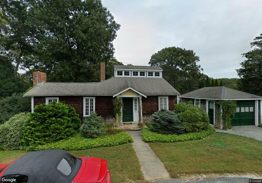
1942 Drift Rd Westport Point, MA 02791
Westport Point NeighborhoodEstimated Value: $782,000 - $1,638,000
3
Beds
--
Bath
1,356
Sq Ft
$837/Sq Ft
Est. Value
About This Home
This home is located at 1942 Drift Rd, Westport Point, MA 02791 and is currently estimated at $1,135,071, approximately $837 per square foot. 1942 Drift Rd is a home with nearby schools including Alice A. Macomber Primary School, Westport Elementary School, and Westport Middle-High School.
Ownership History
Date
Name
Owned For
Owner Type
Purchase Details
Closed on
Mar 16, 2022
Sold by
Cass Beverly
Bought by
Cass Brian and Blue-Moss Polly
Current Estimated Value
Purchase Details
Closed on
Jul 2, 1999
Sold by
Lees Charles W and Lees Beverly C
Bought by
Cass Beverly
Create a Home Valuation Report for This Property
The Home Valuation Report is an in-depth analysis detailing your home's value as well as a comparison with similar homes in the area
Home Values in the Area
Average Home Value in this Area
Purchase History
| Date | Buyer | Sale Price | Title Company |
|---|---|---|---|
| Cass Brian | -- | None Available | |
| Cass Beverly | $7,500 | -- |
Source: Public Records
Mortgage History
| Date | Status | Borrower | Loan Amount |
|---|---|---|---|
| Previous Owner | Cass Beverly | $60,000 | |
| Previous Owner | Cass Beverly | $39,400 | |
| Previous Owner | Cass Beverly | $80,000 |
Source: Public Records
Tax History Compared to Growth
Tax History
| Year | Tax Paid | Tax Assessment Tax Assessment Total Assessment is a certain percentage of the fair market value that is determined by local assessors to be the total taxable value of land and additions on the property. | Land | Improvement |
|---|---|---|---|---|
| 2025 | $5,541 | $743,800 | $529,800 | $214,000 |
| 2024 | $5,447 | $704,700 | $493,700 | $211,000 |
| 2023 | $5,147 | $630,800 | $434,600 | $196,200 |
| 2022 | $4,923 | $580,500 | $419,600 | $160,900 |
| 2021 | $4,383 | $508,500 | $357,100 | $151,400 |
| 2020 | $4,177 | $495,500 | $344,100 | $151,400 |
| 2019 | $4,000 | $483,700 | $344,100 | $139,600 |
| 2018 | $2,365 | $289,500 | $191,500 | $98,000 |
| 2017 | $2,286 | $286,800 | $191,500 | $95,300 |
| 2016 | $2,286 | $289,000 | $191,500 | $97,500 |
| 2015 | $2,197 | $277,000 | $191,500 | $85,500 |
Source: Public Records
Map
Nearby Homes
- 1881 Main Rd
- 1749 Main Rd
- 1702J Drift Rd
- 1702 Drift Rd
- 1580 Main Rd
- 1346 Main Rd Unit B
- 99 Sylvia Ln
- 19 Seabury Ln
- 238-242 E Beach Rd
- 189 Brayton Point Rd
- 304 Brayton Point Rd
- 255 John Dyer Rd
- Lot 2 Horseneck Rd
- 225 Hixbridge Rd
- 920 Drift Rd
- 245 John Dyer Rd
- 17 Quail Trail
- 101 Adamsville Rd
- 837 Main Rd
- Lot 2E Horseneck Rd