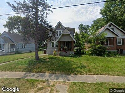
1943 Waltham Ave Cincinnati, OH 45239
Estimated Value: $87,000 - $169,000
2
Beds
2
Baths
1,144
Sq Ft
$121/Sq Ft
Est. Value
About This Home
This home is located at 1943 Waltham Ave, Cincinnati, OH 45239 and is currently estimated at $138,984, approximately $121 per square foot. 1943 Waltham Ave is a home located in Hamilton County with nearby schools including North College Hill Elementary School, North College Hill Middle School, and North College Hill High School.
Ownership History
Date
Name
Owned For
Owner Type
Purchase Details
Closed on
Sep 7, 2000
Sold by
Osterbrock Michael A and Osterbrock Angie M
Bought by
Jackson Anita F
Current Estimated Value
Home Financials for this Owner
Home Financials are based on the most recent Mortgage that was taken out on this home.
Original Mortgage
$76,550
Interest Rate
8.05%
Mortgage Type
FHA
Purchase Details
Closed on
Feb 29, 1996
Sold by
Sneed William Scott and Sneed Carol Jeanne
Bought by
Osterbrock Michael A and Osterbrock Angie M
Home Financials for this Owner
Home Financials are based on the most recent Mortgage that was taken out on this home.
Original Mortgage
$61,098
Interest Rate
7%
Mortgage Type
VA
Create a Home Valuation Report for This Property
The Home Valuation Report is an in-depth analysis detailing your home's value as well as a comparison with similar homes in the area
Home Values in the Area
Average Home Value in this Area
Purchase History
| Date | Buyer | Sale Price | Title Company |
|---|---|---|---|
| Jackson Anita F | $77,000 | -- | |
| Osterbrock Michael A | -- | Midland Title Security Inc |
Source: Public Records
Mortgage History
| Date | Status | Borrower | Loan Amount |
|---|---|---|---|
| Open | Jackson Anita F | $61,831 | |
| Closed | Jackson Anita F | $23,000 | |
| Closed | Jackson Anita F | $74,884 | |
| Closed | Jackson Anita F | $74,884 | |
| Closed | Jackson Anita F | $21,000 | |
| Closed | Jackson Anita F | $76,550 | |
| Previous Owner | Osterbrock Michael A | $61,098 |
Source: Public Records
Tax History Compared to Growth
Tax History
| Year | Tax Paid | Tax Assessment Tax Assessment Total Assessment is a certain percentage of the fair market value that is determined by local assessors to be the total taxable value of land and additions on the property. | Land | Improvement |
|---|---|---|---|---|
| 2024 | $1,598 | $31,595 | $7,014 | $24,581 |
| 2023 | $1,612 | $31,595 | $7,014 | $24,581 |
| 2022 | $1,578 | $22,065 | $6,976 | $15,089 |
| 2021 | $1,545 | $22,065 | $6,976 | $15,089 |
| 2020 | $1,355 | $22,065 | $6,976 | $15,089 |
| 2019 | $1,332 | $19,355 | $6,118 | $13,237 |
| 2018 | $1,333 | $19,355 | $6,118 | $13,237 |
| 2017 | $1,263 | $19,355 | $6,118 | $13,237 |
| 2016 | $1,348 | $22,047 | $6,811 | $15,236 |
| 2015 | $1,351 | $22,047 | $6,811 | $15,236 |
| 2014 | $1,349 | $22,047 | $6,811 | $15,236 |
| 2013 | $1,393 | $23,454 | $7,245 | $16,209 |
Source: Public Records
Map
Nearby Homes
- 1926 Emerson Ave
- 1938 Cordova Ave
- 1917 Emerson Ave
- 1920 Cordova Ave
- 1948 Catalpa Ave
- 1921 Dallas Ave
- 1825 Cordova Ave
- 2029 Sundale Ave
- 1811 Emerson Ave
- 1811 Sterling Ave
- 2030 Innes Ave
- 1914 de Armand Ave
- 1812 Sundale Ave
- 1818 Dallas Ave
- 2125 Mckinley Ave
- 2015 W Galbraith Rd
- 6429 Aspen Way
- 6383 Heitzler Ave
- 1608 Goodman Ave
- 6531 Hamilton Ave
- 1943 Waltham Ave
- 1947 Waltham Ave
- 1941 Waltham Ave
- 1951 Waltham Ave
- 1939 Waltham Ave
- 1935 Waltham Ave
- 1946 Emerson Ave
- 1944 Emerson Ave
- 1942 Emerson Ave
- 1950 Emerson Ave
- 1940 Emerson Ave
- 6522 Simpson Ave
- 6524 Simpson Ave
- 6518 Simpson Ave
- 1942 Waltham Ave
- 1940 Waltham Ave
- 1950 Waltham Ave
- 1931 Waltham Ave
- 1952 Waltham Ave
- 1938 Emerson Ave