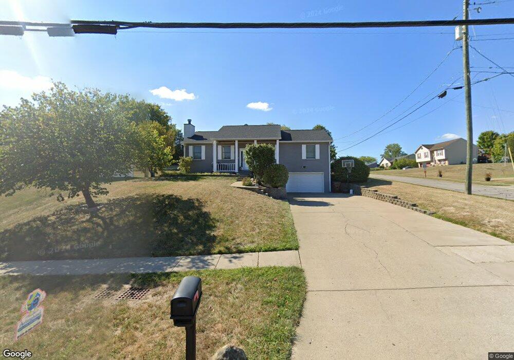
1945 Independence Rd Independence, KY 41051
Estimated Value: $280,000 - $331,000
3
Beds
2
Baths
1,344
Sq Ft
$219/Sq Ft
Est. Value
About This Home
This home is located at 1945 Independence Rd, Independence, KY 41051 and is currently estimated at $294,737, approximately $219 per square foot. 1945 Independence Rd is a home located in Kenton County with nearby schools including Kenton Elementary School, Twenhofel Middle School, and Simon Kenton High School.
Ownership History
Date
Name
Owned For
Owner Type
Purchase Details
Closed on
May 27, 2015
Sold by
Simms John R and Simms Mary
Bought by
Fry Josh A
Current Estimated Value
Home Financials for this Owner
Home Financials are based on the most recent Mortgage that was taken out on this home.
Original Mortgage
$147,283
Outstanding Balance
$114,607
Interest Rate
4.12%
Mortgage Type
FHA
Estimated Equity
$180,130
Purchase Details
Closed on
Mar 1, 2001
Sold by
Ryan Michael P
Bought by
Simms John R and Simms Mary S
Home Financials for this Owner
Home Financials are based on the most recent Mortgage that was taken out on this home.
Original Mortgage
$119,310
Interest Rate
7.06%
Mortgage Type
New Conventional
Create a Home Valuation Report for This Property
The Home Valuation Report is an in-depth analysis detailing your home's value as well as a comparison with similar homes in the area
Home Values in the Area
Average Home Value in this Area
Purchase History
| Date | Buyer | Sale Price | Title Company |
|---|---|---|---|
| Fry Josh A | $150,000 | Associated Title Company | |
| Simms John R | $123,000 | -- |
Source: Public Records
Mortgage History
| Date | Status | Borrower | Loan Amount |
|---|---|---|---|
| Open | Fry Josh A | $147,283 | |
| Previous Owner | Simms John R | $119,310 |
Source: Public Records
Tax History Compared to Growth
Tax History
| Year | Tax Paid | Tax Assessment Tax Assessment Total Assessment is a certain percentage of the fair market value that is determined by local assessors to be the total taxable value of land and additions on the property. | Land | Improvement |
|---|---|---|---|---|
| 2025 | $2,528 | $217,400 | $35,000 | $182,400 |
| 2024 | $2,158 | $176,200 | $30,000 | $146,200 |
| 2023 | $2,224 | $176,200 | $30,000 | $146,200 |
| 2022 | $2,285 | $176,200 | $30,000 | $146,200 |
| 2021 | $2,319 | $176,200 | $30,000 | $146,200 |
| 2020 | $2,027 | $150,000 | $30,000 | $120,000 |
| 2019 | $2,032 | $150,000 | $30,000 | $120,000 |
| 2018 | $2,043 | $150,000 | $30,000 | $120,000 |
| 2017 | $1,987 | $150,000 | $30,000 | $120,000 |
| 2015 | $1,745 | $150,000 | $30,000 | $120,000 |
| 2014 | $1,721 | $135,300 | $30,000 | $105,300 |
Source: Public Records
Map
Nearby Homes
- 5267 Pioneer Dr
- 1804 Cypress Way
- 5186 Christopher Dr
- 10737 Cypresswood Dr
- 5217 Belle Dr
- 10434 Sharpsburg Dr
- 89 Bradley Dr
- 10383 Lynchburg Dr
- 10741 Lakefront Cir
- 72 Sherwood Dr
- 64 Sylvan Dr
- 5086 Woodale Ct
- 109 Sylvan Dr
- 10323 Manassas Ct
- 9947 Meadow Glen Dr
- 1365 Cairns Ct
- 10363 Canberra Dr
- 1436 Rosewynne Way
- Cumberland Plan at Greenbrook - Maple Street Collection
- Wesley Plan at Greenbrook - Maple Street Collection
- 1949 Independence Rd
- 9005 Supreme Ct
- 1941 Independence Rd
- 1953 Independence Rd
- 8991 Supreme Ct
- 9009 Supreme Ct
- 9004 Supreme Ct
- 1922 Appeals Ct
- 1935 Independence Rd
- 1948 Independence Rd
- 1957 Independence Rd
- 8990 Supreme Ct
- 8990 Supreme Ct Unit 8972
- 8990 Supreme Ct Unit 92
- 9008 Supreme Ct
- 8987 Supreme Ct
- 1931 Independence Rd
- 8986 Supreme Ct
- 1904 Appeals Ct
- 1924 Appeals Ct